
Deep South and Southeast States Brace for Unusually Warm Christmas as Temperatures Surge Into the 70s and Low 80s
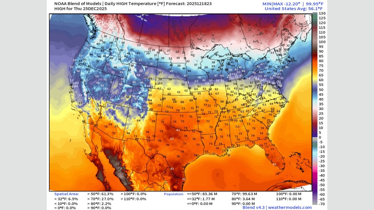
TEXAS — A remarkably warm temperature pattern will dominate Christmas Day across the Deep South and Southeast, where the strongest warm anomalies appear on NOAA’s latest model blend.
Forecast highs from Texas to Florida are expected to soar into the mid-70s to low 80s, creating one of the warmest Christmas periods on record for several Southern states.
NOAA’s temperature analysis reveals that this region is the most significantly impacted, with widespread unseasonably warm conditions fueled by a strong ridge of high pressure and the retreat of Arctic air far into Canada.
Deep South & Southeast: The Most Impacted Region
Texas, Louisiana, Mississippi, Alabama, Georgia, Florida
The strongest warm anomalies clearly appear across the Southern U.S., where many cities will experience temperatures 20–30 degrees above normal:
- Texas: Highs near 80°F, especially in central and southern counties
- Louisiana: Widespread upper 70s
- Mississippi: Mid to upper 70s
- Alabama: Mid-70s, resembling early spring
- Georgia: Low to mid-70s, including Atlanta suburbs
- Florida Panhandle: Pushing near 80°F
These warm readings are rare for late December and place the region at the center of this unusual national warm spell.
Central U.S. Sees Moderate Warmth Going Into Christmas
Oklahoma, Arkansas, Tennessee, Missouri, Kansas
This secondary impact zone shows a broad area of upper 60s to low 70s, including:
- Oklahoma & Kansas: Highs in the upper 60s
- Arkansas & Missouri: Pockets reaching near 70°F
- Tennessee: Mid to upper 60s
While not as extreme as the Deep South warmth, these temperatures remain well above seasonal norms.
Midwest & Mid-Atlantic Experience Mild but Noticeable Holiday Warmth
Illinois, Indiana, Ohio, Virginia, Maryland
The data shows 50s and low 60s stretching across parts of the Midwest and Mid-Atlantic:
- Illinois & Indiana: Highs in the mid to upper 50s
- Ohio: Upper 50s to low 60s
- Virginia & Maryland: Low 60s, with coastal zones slightly warmer
These temperatures are still far from average for late December, but the anomalies are less dramatic compared to the Deep South.
Polar Vortex Stays North, Opening the Door to a Warm Holiday
Meteorologists note that the Polar Vortex remains locked in Canada, preventing typical late-December cold outbreaks from reaching the U.S.
This has allowed:
- A strong southern jet stream
- Persistent warm advection from the Gulf
- Lack of Arctic intrusions into the continental United States
This warm pattern is expected to continue into the final week of the year.
Holiday Weather Outlook
With Christmas Day approaching, residents across the South and Southeast should expect one of the warmest Christmas mornings in recent memory, while the central and eastern states enjoy a milder, less winter-like holiday.
Chicago Music Guide will continue monitoring model updates as the holiday forecast evolves.