
Denver Snow Hype Builds After Bullish 12z Euro Run, But Warm Daytime Temperatures and Northern Track Raise Doubts for Friday
COLORADO — A new 12z ECMWF (Euro) model run is drawing attention for showing a potentially notable snow signal in the Denver area Friday, but growing skepticism remains over whether the setup can truly deliver meaningful accumulation.
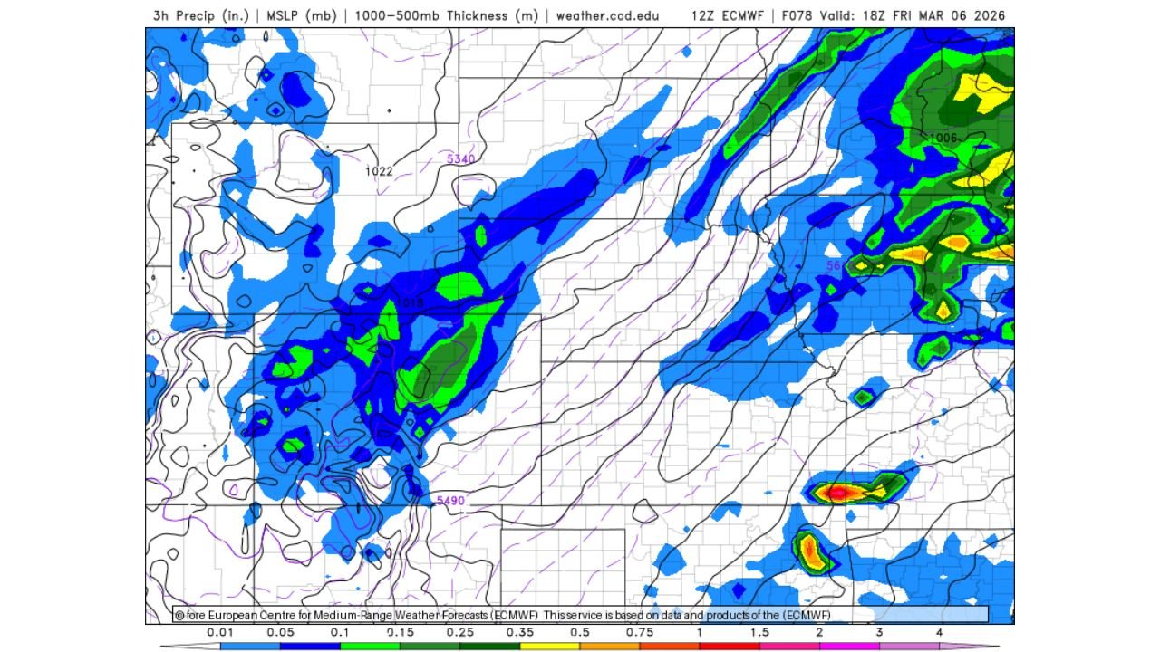
While automated weather apps may already be flagging accumulating snow for the Front Range, forecasters caution that several atmospheric factors could limit totals — especially in the metro area.
What the Euro Model Is Showing
The 12z Euro run depicts:
- A developing low pressure system tracking across the central Rockies
- Precipitation spreading into eastern Colorado, including the Denver metro area
- Sufficient moisture wrapping around the system to generate snowfall potential
However, the projected storm center appears positioned relatively far north, which often favors heavier snow bands north of Denver rather than directly over the city.
Temperature Concerns: Is It Too Warm?
One of the biggest question marks is temperature.
Forecast soundings and thickness values suggest:
- Marginal surface temperatures
- Precipitation falling primarily during daylight hours
- Increasing March sun angle working against accumulation
In early March, even light to moderate snow can struggle to accumulate efficiently on paved surfaces during the day — especially if temperatures hover near or above freezing.
That means snowfall rates would need to be robust to overcome melting.
Timing Matters
The model places much of the precipitation during daytime Friday.
If snowfall intensity remains light to moderate:
- Accumulations could be limited to grassy and elevated surfaces
- Road impacts may be minimal
- Urban core totals could underperform
Heavier, sustained bands would be required to produce meaningful metro accumulation.
Storm Track Also Raises Questions
The placement of the surface low appears slightly north of an ideal track for significant Denver snow.
A more southerly low often enhances upslope flow into the Front Range, increasing snow efficiency. With the system positioned farther north, upslope support may be less optimal.
This setup increases the likelihood of:
- Heavier snow in higher elevations west of Denver
- More marginal outcomes across the city itself
Why Forecasters Urge Caution
Automated weather apps often latch onto raw model output without factoring in:
- March sun angle effects
- Urban heat island influence
- Daytime melting
- Subtle track shifts
Small adjustments in storm track or thermal profile could dramatically change snow outcomes.
Who Should Watch Closely
While skepticism exists for Denver proper, nearby areas that could see better snow chances include:
- Higher elevations west of the metro
- Foothill communities
- Northern sections closer to stronger deformation bands
Residents in and around Denver, Boulder, and Fort Collins should continue monitoring updated forecasts as model trends evolve.
Bottom Line
The 12z Euro run paints a bullish picture for Denver snow Friday, but warm daytime temperatures, March sun angle, and a northern storm track raise legitimate doubts about significant accumulation in the metro area.
Higher terrain may fare better, while Denver’s outcome remains uncertain and highly dependent on intensity and timing.
ChicagoMusicGuide.com will continue tracking national weather developments as this Colorado snow setup becomes clearer.