
East Coast Nor’easter Strengthens Toward 974mb as Blizzard Conditions Threaten Beaches and Cold Air Surges Into Florida
NEW YORK, NEW YORK — A rapidly strengthening Nor’easter is trending farther west and intensifying along the East Coast, with forecast models showing a deepening low pressure system that could reach 974mb early Monday morning. The storm is expected to bring blizzard conditions along coastal beaches, heavy snow across parts of the Northeast, and a surge of colder air into the Southeast, including Florida by Tuesday morning.
Forecast guidance based on the GFS model shows the system organizing offshore late Sunday night into early Monday, with impacts stretching from the Mid-Atlantic through New England.
Storm Track Trends West and Stronger
Recent updates indicate the FOX Weather Model, derived from the GFS, continues to trend the storm slightly farther west. That shift is critical. A more westward track brings heavier precipitation closer to major population centers including New York City, Long Island, coastal New Jersey, and parts of Connecticut and Massachusetts.
At 12:30 a.m. Monday (Feb. 23), forecast imagery shows a well-defined low pressure center just offshore of the Delmarva Peninsula, with widespread precipitation wrapping around the circulation. Snow bands are projected across inland areas while intense rain and wind lash the coastal corridor.
The biggest question remains how far inland the heaviest snow penetrates. Even small track adjustments could mean the difference between moderate snowfall and significant accumulation for cities along the I-95 corridor.
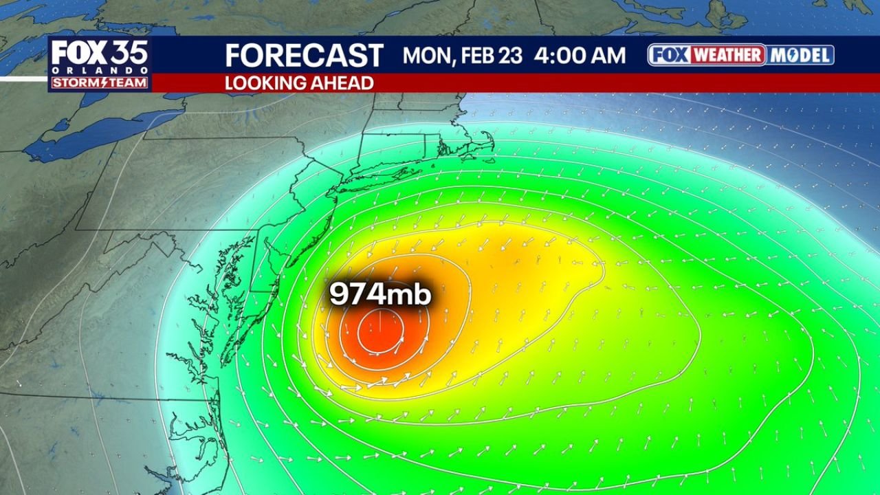
974mb Low Signals Powerful Coastal Impact
By 4:00 a.m. Monday, the storm is projected to deepen to approximately 974 millibars, a notably strong pressure reading for a winter coastal system. For context, lower millibar readings indicate stronger storms, and a 974mb Nor’easter signals a tightly wound circulation capable of producing damaging winds and whiteout conditions.
The pressure gradient surrounding the storm suggests strong onshore winds, particularly for coastal communities in New Jersey, Long Island, Rhode Island, and eastern Massachusetts. These winds could generate:
- Blizzard conditions along exposed beaches
- Reduced visibility from blowing snow
- Coastal flooding concerns in vulnerable shoreline areas
Snowfall intensity near the storm’s deformation band could become significant, especially where colder air locks in.
Heavy Snow Potential and Inland Uncertainty
Forecast graphics show a broad shield of precipitation arcing across the Northeast. Areas north and west of the low center — including parts of Pennsylvania, upstate New York, and interior New England — are positioned for snow.
However, forecasters caution that the exact inland snow line remains uncertain. If the storm tracks slightly farther offshore, heavier snow may remain concentrated along the immediate coast. If it shifts farther west, metropolitan areas could see more substantial accumulations.
The evolving storm structure features a warm front extending eastward over the Atlantic and a trailing cold front sweeping southward. This configuration enhances lift and moisture transport — key ingredients for heavy precipitation.
Southeast Feels the Cold Pull
While the Northeast braces for snow and wind, the storm’s strength will have ripple effects well beyond the immediate impact zone. A deeper and stronger coastal low tends to pull more Arctic air southward behind it.
Forecast discussions highlight that Florida could feel noticeably colder air by Tuesday morning, as the departing Nor’easter helps draw cold air deeper into the Southeast. Temperatures are expected to dip compared to recent averages, marking a sharp change following the storm’s passage.
This cold push is not tied to snowfall in Florida but rather to the larger atmospheric pattern shift triggered by the powerful coastal system.
Timing and What to Watch
Key timing based on the latest projections:
- Late Sunday Night: Storm organizes offshore
- Early Monday (12:30 a.m. – 4:00 a.m.): Low deepens toward 974mb
- Monday Morning: Peak coastal wind and snowfall intensity
- Tuesday: Colder air filters into the Southeast, including Florida
Residents across the Mid-Atlantic and Northeast should monitor updates as track shifts of even 50–75 miles could significantly change local snowfall totals and wind impacts.
As coastal communities prepare for potential blizzard conditions and inland areas assess snow risk, the evolving track will remain the most critical factor over the next 24–48 hours.
As this powerful East Coast Nor’easter develops, its strength and westward trend are raising the stakes for millions from New Jersey to New England, while also influencing temperature changes across the Southeast. For continued updates on major weather systems affecting communities nationwide, visit ChicagoMusicGuide.com.