
ECMWF Snow Signal Points to Possible Late-Week Wintry Setup Across Ohio, Pennsylvania, New York, and New England
UNITED STATES — New long-range guidance from the ECMWF ensemble system is flashing a snow signal for parts of the Eastern United States, suggesting that a late-week storm system could bring wintry precipitation to portions of the Ohio Valley, Mid-Atlantic, and Northeast, including Ohio, Pennsylvania, New York, and interior New England. While this signal does not represent a finalized forecast, it is an early indicator that the atmospheric pattern may support snow in climatologically favored areas.
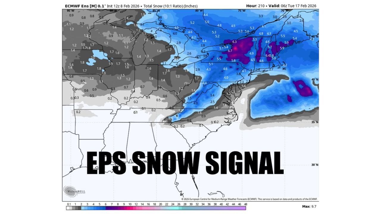
What the EPS Snow Map Is Showing
The ECMWF ensemble snowfall graphic highlights a broad swath of light to moderate snow probabilities stretching from the central Appalachians through interior Pennsylvania and New York, with stronger ensemble clustering across higher elevations and northern latitudes. Several ensemble members depict multiple inches of snow, particularly in colder interior zones, while lower elevations trend lighter or mixed.
This type of output reflects ensemble agreement, not certainty — meaning enough model members are seeing snow to warrant attention, but not enough yet to lock in impacts.
Why This Is a Signal — Not a Forecast
At this range, EPS snowfall maps should be viewed as pattern recognition tools. They help forecasters identify where storm tracks may align with cold air, but they do not resolve:
- Exact storm timing
- Surface low placement
- Rain vs. snow boundaries
- Elevation-dependent impacts
A shift of just 50–100 miles in track or a small change in temperature profiles could dramatically change outcomes.
Cold Air Is the Key Variable
The biggest question remains cold air availability. While upper-level support is evident, the depth and placement of cold air ahead of the system will determine whether:
- Snow becomes the dominant precipitation type
- A rain/snow mix develops
- Or precipitation falls mainly as rain in lower elevations
Right now, the ensemble footprint follows typical February climatology, favoring snow inland and north, with marginal conditions closer to the coast.
Regions Most Worth Watching
Based on the current ensemble clustering, the areas with the highest snow potential include:
- Central and eastern Ohio
- Interior Pennsylvania
- Upstate New York
- Higher elevations of New England
Coastal areas remain more uncertain and may stay predominantly rain unless colder air trends south.
Timing Window
The signal aligns with a potential storm window late next week into the following weekend, though exact timing will continue to shift as the system comes into range of higher-resolution models.
Bottom Line
A legitimate EPS snow signal is emerging for parts of the Eastern U.S., centered on Ohio, Pennsylvania, New York, and New England, but confidence in exact impacts remains low at this stage. This is a setup worth monitoring — not a forecast to act on yet.
As the system moves closer and enters the short-range window, clearer answers on snowfall amounts, rain/snow lines, and travel impacts will follow.
Stay with ChicagoMusicGuide.com for continued updates as this developing winter signal becomes clearer in the days ahead.