Florida Cities Hit a Heat Index of 100 Degrees Saturday in the First True Summer Heat Preview of 2026 Before a Cool Front Arrives
MIAMI, FL — Summer is sending its first calling card to Florida. For the first time in 2026, several cities across the Florida Peninsula will feel a heat index — the combination of actual air temperature and humidity that determines what the air actually feels like on human skin — of 100 degrees Fahrenheit or higher on Saturday. It is a preview of the oppressive heat season that Florida residents know is coming, arriving briefly before a cool front sweeps through and temporarily resets conditions.
Think of Saturday as summer knocking on the door before anyone officially answered.
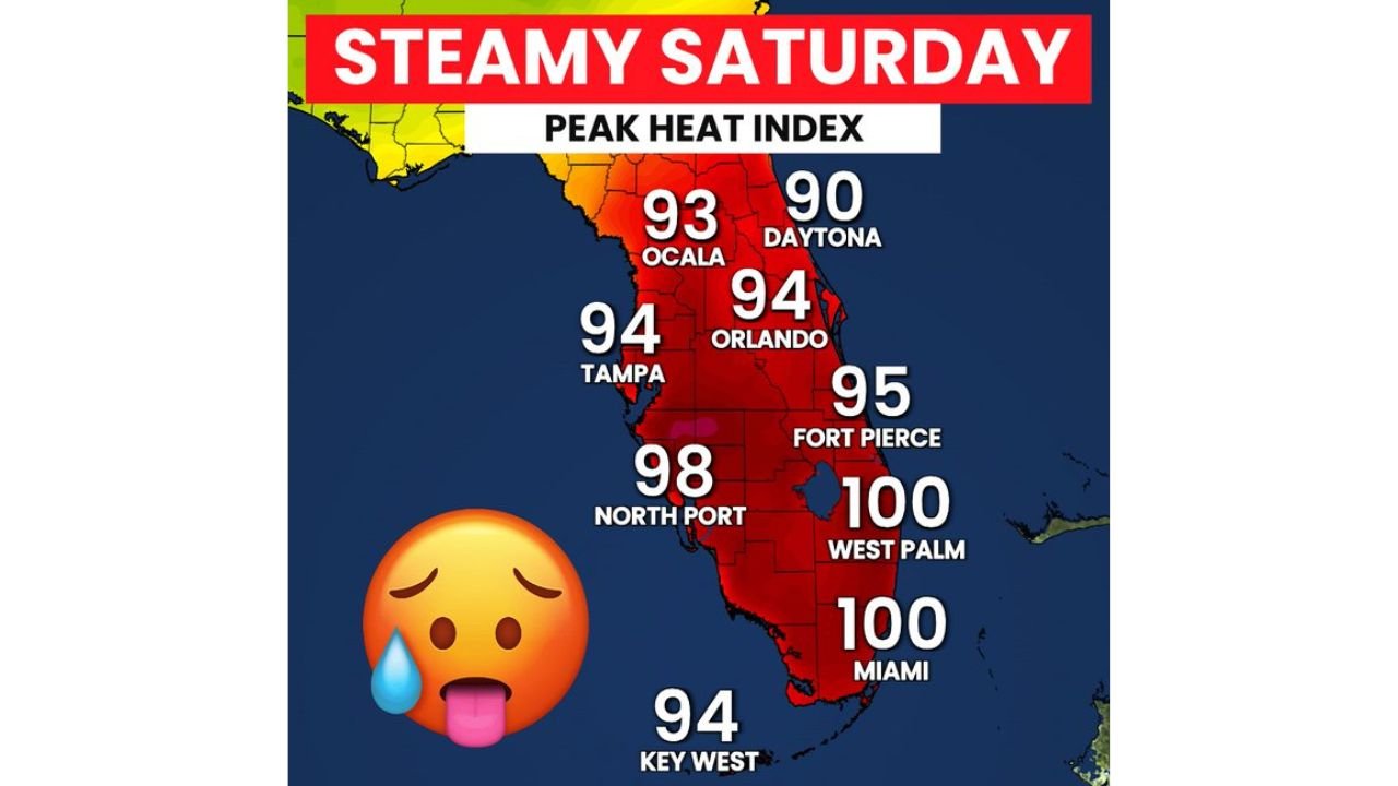
Peak Heat Index Values Across Florida Saturday
Current analysis shows a clear north-to-south gradient in heat index values across the peninsula Saturday, with the most extreme feels-like temperatures concentrated along the Atlantic Coast and across south Florida.
Miami and West Palm Beach top the chart at 100 degrees each — the first time either city has reached the triple-digit heat index mark in 2026. North Port in Sarasota County on the Gulf Coast reaches 98 degrees. Fort Pierce on the Treasure Coast hits 95. Tampa and Orlando both reach 94, while Ocala registers 93 and Key West comes in at 94. Even Daytona Beach on the upper Atlantic Coast reaches a feels-like temperature of 90 degrees — warm enough to pose heat stress concerns for outdoor workers and vulnerable populations.
The entire Florida Peninsula is blanketed in heat index values running 10 to 15 degrees above actual air temperatures, driven by the extraordinarily high atmospheric humidity that defines Florida’s pre-frontal airmass in late April and early May.
Why Saturday Feels This Hot
The driver behind Saturday’s oppressive heat index readings is a moisture-rich airmass sitting over Florida ahead of an approaching cold front. Surface dewpoints — the most direct measure of atmospheric moisture — are running well into the 70s Fahrenheit across much of the peninsula, with values approaching 75 to 78 degrees across south Florida. When dewpoints reach these levels, the human body’s ability to cool itself through sweating becomes significantly impaired. Sweat cannot evaporate efficiently into air that is already nearly saturated with moisture, leaving the body to absorb heat rather than shed it.
The result is what meteorologists measure as the heat index — a value that quantifies what the body actually experiences rather than what the thermometer reads. At a heat index of 100 degrees, outdoor exertion carries a real risk of heat exhaustion and heat cramps for anyone without adequate hydration and shade, and heat stroke becomes a danger during prolonged exposure.
City-by-City Peak Heat Index Table
| City | Peak Heat Index Saturday | Region |
|---|---|---|
| Miami | 100 degrees | Southeast Florida |
| West Palm Beach | 100 degrees | Treasure Coast / SE Florida |
| North Port | 98 degrees | Southwest Florida Gulf Coast |
| Fort Pierce | 95 degrees | Treasure Coast |
| Tampa | 94 degrees | Tampa Bay / Gulf Coast |
| Orlando | 94 degrees | Central Florida |
| Key West | 94 degrees | Florida Keys |
| Ocala | 93 degrees | North-Central Florida |
| Daytona Beach | 90 degrees | Northeast Florida Atlantic Coast |
What the Cool Front Means
The approaching cold front that follows Saturday’s heat surge will bring measurable relief to Florida by the weekend’s end. Cooler and drier air filtering behind the front will drop heat index values back into the more comfortable 80s across most of the peninsula, providing a temporary reprieve before the summer heat pattern reasserts itself in the weeks ahead.
This front-and-heat sequence — extreme pre-frontal warmth followed by brief post-frontal relief — is a pattern Florida residents will see repeatedly through May and into June as the atmosphere transitions from spring to full summer. Each successive front typically provides less relief than the one before it as sea surface temperatures warm and the overall airmass becomes increasingly summer-like. By June, the fronts stop bringing meaningful cooling entirely and Florida settles into its months-long heat season.
Heat Safety for Saturday
Anyone spending time outdoors across Florida on Saturday — particularly in Miami, West Palm Beach, North Port, and Fort Pierce where heat index values reach 95 to 100 degrees — should follow standard heat safety practices. Hydrate continuously and do not wait until thirst sets in. Limit strenuous outdoor activity to early morning hours before 10 AM and after 6 PM. Wear lightweight, light-colored, loose-fitting clothing. Never leave children or pets in parked vehicles under any circumstances. Check on elderly neighbors and family members who may not have access to air conditioning.
Heat index values at or above 100 degrees are classified by the National Weather Service as conditions where heat cramps and heat exhaustion are likely with prolonged exposure and physical activity, and heat stroke is possible.
Forecast Confidence
Confidence in heat index values reaching 100 degrees across Miami and West Palm Beach on Saturday is HIGH. Confidence in the broader peninsula-wide heat index values shown in current analysis is HIGH. Confidence in the approaching cool front providing meaningful relief by Sunday is MODERATE to HIGH based on current model data.
Saturday is a preview of what Florida summers deliver for months at a time. Treat it with the respect the heat deserves.
More weather coverage is always on the horizon. Stay informed at ChicagoMusicGuide.com — your source for heat alerts, front tracking, and breaking weather coverage across Florida and the entire United States.