
Florida Faces Season’s Sharpest Cold Snap With Near-Freezing Morning Temperatures Expected Friday
FLORIDA — A sharp blast of Arctic air is forecast to sweep deep into the Sunshine State by early Friday morning, bringing what meteorologists are calling the coldest air of the season to much of Florida, including areas that rarely experience near-freezing conditions.
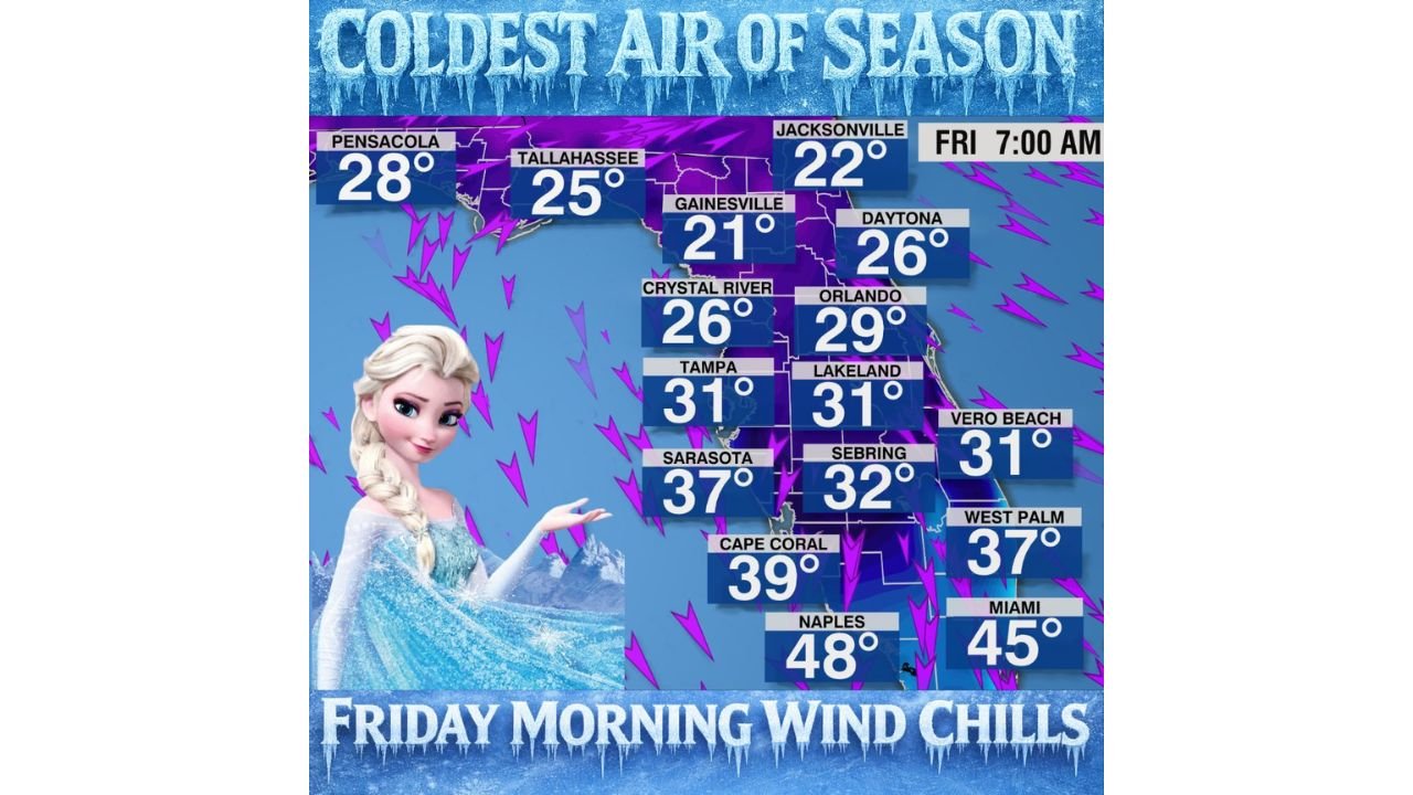
Forecast graphics show sub-freezing temperatures across North and Central Florida, with unusually cold wind chills reaching into South Florida, including the Miami–Fort Lauderdale–West Palm Beach corridor. While confidence is still evolving on just how far south the coldest air will reach, the overall signal for a significant cold morning is strong.
Cold Air Penetrates Farther South Than Typical Florida Events
Unlike many winter cold snaps that stall over North Florida, this system appears strong enough to drive true Arctic air well into the peninsula. Forecast wind chill values early Friday suggest temperatures falling into the low 20s across North Florida, with mid to upper 20s across parts of Central Florida.
Cities including Jacksonville, Gainesville, Tallahassee, and Daytona Beach are projected to experience their coldest morning so far this season, while Orlando, Tampa, and Lakeland could see readings hovering near the freezing mark.
South Florida Not Immune as Wind Chills Drop Sharply
Even areas that typically avoid winter cold may feel the impact. Forecasts indicate wind chills in the upper 30s to mid-40s across South Florida, including Miami, Naples, West Palm Beach, and Fort Lauderdale.
While actual air temperatures may stay above freezing in the far south, persistent northerly winds could make conditions feel much colder than usual for the region, especially during the early morning commute.
Why This Cold Snap Is Different
Meteorological data shows a deep trough in the jet stream, allowing polar air to surge southward without quickly moderating. This pattern is more typical of mid-winter cold outbreaks across the central and eastern United States, not Florida.
Forecasters note that while exact temperature values may still shift slightly, the overall cold signal is locked in, with only minor adjustments expected over the next few forecast cycles.
Timing and What to Expect
- Coldest conditions: Early Friday morning (around 6–8 a.m.)
- Greatest impacts: North and Central Florida
- Key concern: Wind chills, especially before sunrise
- Still uncertain: How far south freezing temperatures reach
Residents are urged to prepare for unusually cold morning conditions, protect sensitive plants, and ensure pets and vulnerable individuals have adequate warmth.
What Comes Next
While this event marks the coldest air of the season so far, forecasters are continuing to monitor additional winter patterns developing later in the month, which could bring further temperature swings across the Southeast.
As Florida experiences one of its most significant cold mornings of the season, staying informed is essential — especially for travelers, outdoor plans, and live events affected by early-morning conditions. For continued weather updates, forecast breakdowns, and major pattern shifts impacting the U.S., keep following ChicagoMusicGuide.com for timely and reliable coverage.