
Florida Panhandle and North Florida Expected to Face Significant Early-Week Cold Blast as Temperatures Drop Into the 20s
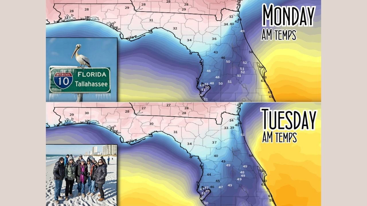
FLORIDA — A sharp and unusually early-season cold blast is set to hit the Sunshine State early this week, with the Florida Panhandle and North Florida expected to experience the most dramatic temperature plunge. Forecast maps show morning lows falling into the 20s and low 30s, while central and south Florida will see widespread 40s and low 50s to start the day on Monday and Tuesday.
The cold air arrives behind a strong front sweeping southeast across the region, bringing one of the most noticeable temperature drops of the month — particularly for areas along and north of Interstate 10.
Significant Temperature Drop for the Panhandle
Forecast graphics show the most dangerous cold centered over the Panhandle, where areas such as Tallahassee, Crestview, and Pensacola may fall to 28–31°F on Monday morning and remain below freezing again into Tuesday.
Wind chills will make temperatures feel even colder, pushing “feels-like” values into the upper teens and low 20s during the early morning hours.
Residents in these counties should prepare for:
- Frozen pipes in poorly insulated homes
- Unsafe overnight wind chills for unprotected skin
- Harm to sensitive pets or outdoor animals
- Potential agricultural impacts
This cold event is not expected to push deeply into the peninsula, but the Panhandle will experience conditions more typical of mid-winter than early December.
Central and North Florida Wake-Up Temperatures in the 30s and 40s
While the Panhandle faces freezing conditions, North Florida cities including Gainesville, Lake City, and Jacksonville will see 30s to near 40°F both Monday and Tuesday mornings.
Meanwhile, Central Florida — including Orlando, Daytona Beach, and Tampa — is expected to wake up to lows in the mid-40s to around 50°F, noticeably colder than previous weeks but not extreme.
Despite the sharp drop, temperatures are not expected to remain low for long. The coldest period will occur early Monday and Tuesday mornings before a steady warm-up moves in late week.
South Florida Feeling the Chill — But Not Freezing
South Florida will still feel the effects of the cold blast, though to a much milder degree. Miami, Fort Lauderdale, Naples, and the Keys are forecast to start Monday and Tuesday in the upper 40s to low 50s, with coastal areas running slightly warmer.
While these temperatures are far from dangerous, residents accustomed to tropical mornings will definitely feel the difference.
Cold Blast Will Be Brief Before Warmer Weather Returns
Forecasters note that this cold wave is short-lived, with a gradual warm-up beginning mid-week. By the time Santa arrives, much of Florida should be back to more seasonable temperatures.
Still, residents in the hardest-hit regions — especially the Panhandle — are urged to take precautions now:
- Bring pets indoors
- Protect plants or cover them overnight
- Prepare for icy car windshields Monday and Tuesday mornings
- Layer clothing before heading to work or school
Stay Informed With ChicagoMusicGuide Weather Coverage
Weather changes quickly, and cold fronts like this one often shift temperature ranges within just a few hours. Stay tuned to ChicagoMusicGuide.com for continuing updates on temperature trends, upcoming warm-ups, and any additional frost or freeze concerns across the U.S.