
Florida Panhandle, North Florida and Southern Georgia Face Tornado Threat Sunday as Linear Storm Line Targets Tallahassee, Jacksonville and Mobile
UNITED STATES — A renewed severe weather threat is shaping up across the Southeast on Sunday, with the primary focus stretching from the Florida Panhandle through North Florida and into Southern Georgia, where forecasters warn a few tornadoes could develop within a fast-moving line of storms.
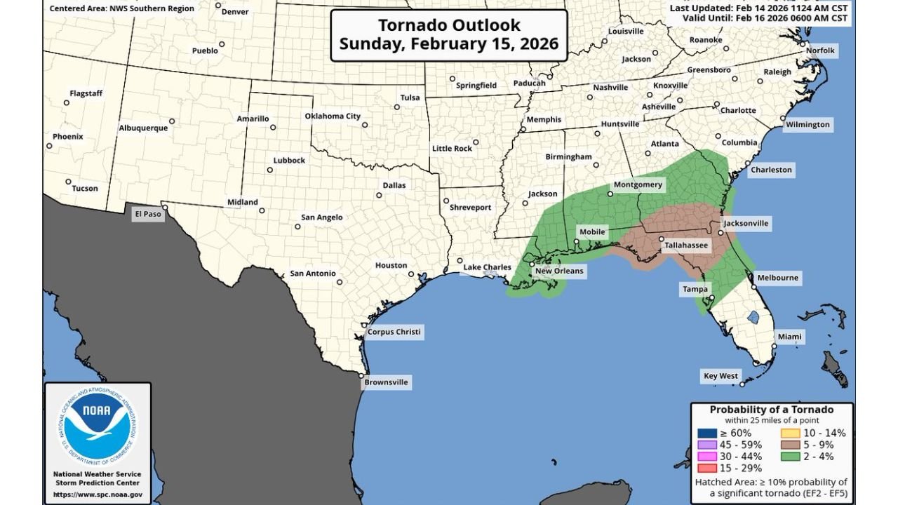
New outlook data for Sunday, February 15, 2026, highlights a corridor from Mobile, Alabama, across Tallahassee, Florida, and into areas near Jacksonville, Florida, under an elevated tornado probability zone. While this is not expected to be a classic supercell outbreak, atmospheric ingredients suggest at least one or two strong tornadoes could spin up within the line.
Tornado Outlook Centers on Florida Panhandle and Southern Georgia
The Storm Prediction outlook places the highest concern across:
- Florida Panhandle
- North Florida
- Southern Georgia
- Coastal sections near Mobile, Alabama
- Areas just inland from the Gulf Coast
The highlighted zone includes cities such as Tallahassee, Mobile, and Jacksonville, with the greatest concern concentrated from the Panhandle eastward.
Probability shading indicates a measurable risk of tornadoes within 25 miles of a point, with some areas carrying enhanced concern for significant tornado potential (EF2–EF5) embedded within the broader threat area.
Storm Mode Expected to Be Linear — But Don’t Let That Fool You
Unlike classic isolated supercells, Sunday’s setup favors a linear squall line structure pushing east across the Gulf states.
Forecast model imagery shows:
- A solid band of intense thunderstorms stretching from southern Alabama into the Florida Panhandle
- Strong reflectivity cores embedded within the line
- Increasing low-level wind shear ahead of the storms
This is a low-CAPE, high-shear environment, meaning instability isn’t extreme, but wind energy in the lower atmosphere is significant. That combination can allow tornadoes to quickly spin up within the line — sometimes with little warning.
Sounding analysis indicates:
- Strong low-level directional shear
- Favorable critical angle values
- Tornado parameters supportive of brief but potentially strong circulations
Forecasters emphasize that even if only a few tornadoes form, one or two could become strong within the embedded circulations.
Timing and Impact Window
Model guidance suggests:
- Storms advancing eastward Sunday
- Greatest tornado risk during peak line intensity as it crosses North Florida and Southern Georgia
- Damaging straight-line winds also likely along the leading edge
Residents in:
- Mobile
- Tallahassee
- Jacksonville
- Portions of southern Georgia near the Florida border
should monitor weather alerts closely.
Why This Setup Is Concerning
While this isn’t a widespread, classic high-end tornado outbreak scenario, there are a few red flags:
- Intense low-level wind shear
- Organized linear convection
- Potential for brief strong tornadoes embedded within the line
- Fast storm motion limiting warning lead time
Linear tornadoes can be especially dangerous because they may be rain-wrapped, fast-moving, and difficult to visually confirm.
What Residents Should Do
If you’re located across the Florida Panhandle, North Florida, or Southern Georgia:
- Have multiple ways to receive warnings
- Identify your safe room ahead of time (interior room, lowest level, away from windows)
- Avoid relying solely on outdoor sirens
- Stay weather-aware throughout Sunday
This system may not produce numerous tornadoes — but it only takes one.
As this severe weather threat unfolds, Chicagomusicguide.com will continue monitoring major storm developments impacting communities nationwide. Stay alert, stay informed, and make sure you’re prepared before the storms arrive.