
Georgia Snow Appears in Euro Model Beyond 7 Days, But Ensemble Data Keeps Confidence Very Low Across the Southeast
UNITED STATES — A recent run of the European weather model is drawing attention after briefly showing potential snowfall in Georgia in the extended forecast window next week. While the graphic has circulated quickly online, a closer look at the underlying data shows this signal remains highly uncertain and well outside reliable forecasting range.
What the Latest Euro Model Run Is Showing
The latest ECMWF (Euro) operational run depicts a scenario where cold air pushes unusually far south into the Southeast, overlapping with available moisture and briefly producing snowfall over parts of Georgia beyond the standard seven-day forecast window.
Snowfall signals this far south are rare and typically require near-perfect alignment of cold air, storm track, and moisture. Because of this, single-run snow depictions in Georgia immediately raise red flags among forecasters.
Ensemble Guidance Strongly Disagrees
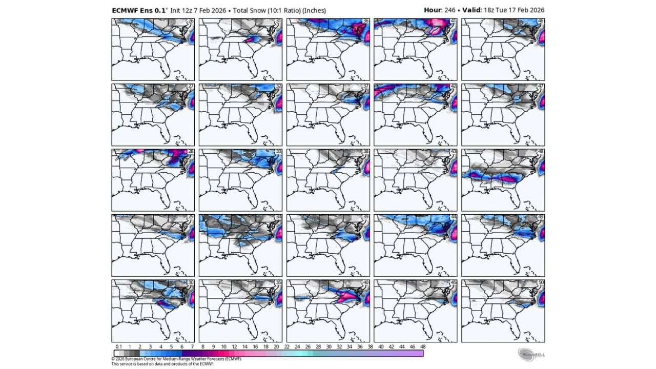
While the operational Euro run shows snow, the ensemble data tells a very different story.
The ECMWF ensemble includes 50 different members, each representing a plausible version of the atmosphere.
- Only 2 out of 50 ensemble members show snow in Georgia
- That represents about 4% support
- The remaining 96% of ensemble members show no snow
When ensemble support is this low, meteorologists classify the signal as an anomaly rather than a forecast trend.
Why This Snow Signal Is Low Confidence
Several factors keep confidence extremely limited at this stage:
- The signal appears beyond the 7-day forecast window
- Cold air delivery into the Deep South is highly sensitive to small track changes
- Moisture timing must be exact for snow to occur in Georgia
- No consistency has appeared across multiple model cycles
Without repeat signals and growing ensemble agreement, the scenario remains speculative.
Why Forecasters Are Waiting for a Trend
Experienced forecasters prioritize pattern repetition, not single-run excitement. Southern snow events are frequently hinted at in long-range guidance but disappear as models correct temperature profiles or storm placement.
Until multiple model runs show similar outcomes — and ensemble support increases — there is no scientific basis for elevating this scenario.
What Would Increase Confidence Going Forward
Confidence would rise quickly if future guidance shows:
- Increasing ensemble participation
- Repeat snow signals in multiple Euro runs
- Confirmation from other global models
- A sustained cold pattern across the Southeast
At this point, none of those signals are present.
Bottom Line for Georgia and the Southeast
- A single Euro run shows snow potential in Georgia
- Ensemble data overwhelmingly rejects the idea
- Confidence remains very low
- No actionable forecast exists at this time
For now, this is best classified as model noise, not a developing winter event.
What Happens Next
Forecasters will continue monitoring upcoming model cycles to see whether this idea fades — or begins to show consistency. Until then, patience is critical.
Stay with Chicagomusicguide.com for calm, data-driven winter weather analysis — without hype, overreaction, or misleading headlines.