
Great Lakes Bomb Cyclone Expected to Trigger Blizzard Conditions in Wisconsin, Michigan, and Ontario With 60 mph Winds and Up to 2 Feet of Snow
GREAT LAKES REGION — A rapidly intensifying storm system is in its early stages of development and is forecast to “bomb out” over the Great Lakes by Sunday evening, bringing widespread, high-impact winter weather to the Upper Midwest and Great Lakes region. Forecast data indicates blizzard conditions, damaging winds, and significant snowfall, with the most severe impacts expected across northern Wisconsin, Michigan’s Upper Peninsula, and parts of Ontario.
Meteorologists warn this system could become one of the most disruptive winter storms of the season for areas surrounding Lakes Superior, Michigan, Huron, Erie, and Ontario.
Blizzard Conditions Likely Across the Upper Midwest and Great Lakes
As the storm rapidly strengthens, blizzard conditions are expected to develop across large portions of the Upper Midwest and Great Lakes, particularly downwind of the major lakes. Sustained winds combined with heavy snowfall are likely to reduce visibility to near zero for extended periods.
Whiteout conditions may persist for many consecutive hours, making travel extremely dangerous or impossible. High snowdrifts are also expected, especially in open and rural areas where strong winds can pile snow rapidly.
Extreme Winds Forecast Across the Region
Wind will be a major component of this storm. Forecast guidance shows 50–60 mph wind gusts over the open waters of the Great Lakes, with 35–45+ mph gusts inland across surrounding states and provinces.
These winds will significantly worsen travel conditions, increase the risk of power outages, and contribute to widespread blowing and drifting snow. Areas closest to the lakes are expected to see the strongest gusts, but impacts will extend far inland.
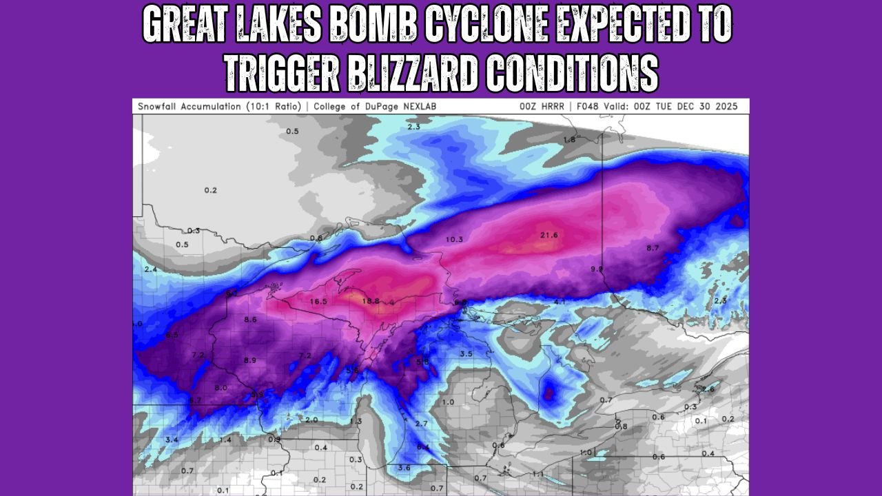
Heaviest Snow Targets Northern Wisconsin, Upper Michigan, and Ontario
The majority of snowfall from this system is expected to fall across northern Wisconsin, Michigan’s Upper Peninsula, and portions of Ontario, where snow totals may exceed 12 inches, with localized amounts approaching or exceeding 2 feet.
Snowfall rates could become intense during the peak of the storm, overwhelming road crews and making plowing operations difficult or ineffective during the height of the event. Lake-enhanced and lake-effect processes will further amplify snowfall in favored locations.
Great Lakes Play a Critical Role in Storm Severity
The presence of the Great Lakes will dramatically enhance the storm’s impacts. Cold air moving over relatively warmer lake waters will intensify snowfall bands and increase wind speeds, particularly east and southeast of each lake.
Communities near Lake Superior and Lake Michigan face the highest risk for prolonged blizzard conditions, while areas downwind of Lakes Huron, Erie, and Ontario may experience periods of severe blowing snow and reduced visibility.
Travel and Safety Concerns Mount Ahead of Peak Impacts
Officials are urging residents across the most impacted areas to avoid unnecessary travel, especially during the height of the storm Sunday night into Monday. Roads may become impassable, and emergency response times could be delayed due to dangerous conditions.
Those in vulnerable areas are advised to prepare for possible power outages, secure outdoor items, and ensure adequate supplies are on hand before conditions deteriorate.
As this powerful Great Lakes storm rapidly intensifies and spreads dangerous winter weather across multiple states and provinces, staying informed will be critical. For continued updates on Great Lakes weather, blizzard warnings, and storm impacts, visit ChicagoMusicGuide.com for the latest forecasts and regional coverage.