
Illinois, Indiana and Kentucky Face Conditional Tornado Threat as Warm Front Placement Could Decide Between Large Hail or Significant Twisters
ILLINOIS — A volatile weather setup is unfolding across portions of Illinois, Indiana, and Kentucky, where the placement of a warm front may ultimately determine whether the region sees mainly large hail producers — or a more dangerous tornado threat.
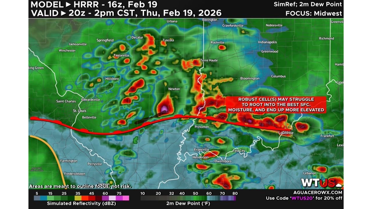
High-resolution model guidance valid for Thursday afternoon shows clusters of strong storms developing along and north of the warm front, which is draped from southern Illinois into southern Indiana and central Kentucky. However, forecasters stress that the key uncertainty lies in whether supercells can fully root into the unstable surface air south of that boundary.
Where Storms Are Expected to Develop
Simulated radar imagery from the afternoon model run shows:
- Strong storms near Springfield, Decatur, and Taylorville, Illinois
- Developing cells around Terre Haute and Newton, Indiana
- Intense convection approaching Louisville, Kentucky
- Activity near Princeton and Evansville
Much of this convection appears aligned along or just north of the warm front, which stretches roughly west-to-east across southern Illinois into southern Indiana and Kentucky.
Elevated vs Surface-Based: Why It Matters
The primary forecast challenge centers on storm structure.
If the strongest cells remain north of the warm front, they may struggle to access the richest surface moisture. In that case:
- Storms become more elevated
- The large hail threat increases
- The tornado threat remains more limited
However, if storms can form and remain south of the warm front, where surface dew points are higher and wind profiles are more favorable:
- Supercells could become fully surface-based
- Wind shear could support rotating storms
- The risk for significant tornadoes increases
This distinction hinges on just tens of miles in boundary placement.
Cities Most Closely Watching the Warm Front
Communities near the boundary will be most sensitive to storm evolution, including:
- St. Louis (near the northern fringe of activity)
- Springfield and Decatur, Illinois
- Terre Haute and Bloomington, Indiana
- Louisville, Kentucky
- Areas near Evansville and Henderson
A subtle northward shift of the warm front would expand the tornado window. A southward or stalled boundary would favor more hail-dominant storms.
Atmospheric Ingredients in Place
Wind profiles across the region are supportive of organized convection. The concern is not a lack of shear, but whether storms can tap into the most unstable surface air mass.
Forecasters note:
- Strong mid-level winds
- Sufficient instability south of the boundary
- Forcing concentrated along and north of the warm front
The overlap — or lack thereof — between instability and forcing will determine the outcome.
Timing: Mid to Late Afternoon Into Evening
Storms are expected to intensify during the afternoon hours, particularly as daytime heating maximizes instability. The most critical period will likely extend from mid-afternoon into early evening across southern Illinois, central Indiana, and northern Kentucky.
Residents should be prepared for rapidly changing conditions, especially if storms begin organizing south of the warm front.
What Residents Should Do
Across Illinois, Indiana, and Kentucky, residents should:
- Monitor real-time radar and warnings
- Have multiple ways to receive severe weather alerts
- Identify safe shelter locations in advance
The difference between a hail-heavy event and a tornado-producing setup could come down to small-scale boundary shifts. As storms begin to fire this afternoon, forecasters will be watching closely to see which scenario unfolds.
ChicagoMusicGuide.com will continue tracking developments as the warm front and supercell evolution determine the severity of today’s storm threat.