
Illinois, Indiana, Kentucky and Tennessee Face Growing Tornado Threat as Ohio Valley Risk Trends Upward
INDIANAPOLIS, INDIANA — A growing tornado threat is taking shape across the Ohio Valley, with updated high-resolution model guidance showing an uptick in tornado potential across Illinois, Indiana, Kentucky, Tennessee, and southern Ohio. Forecast data suggests that Thursday afternoon into the early evening could bring a few tornadoes, particularly if instability and low-level moisture increase as expected.
While this was never forecast to be a widespread outbreak, recent model runs show enough atmospheric alignment to warrant heightened attention.
Elevated Tornado Corridor Centered Over Indiana and Kentucky
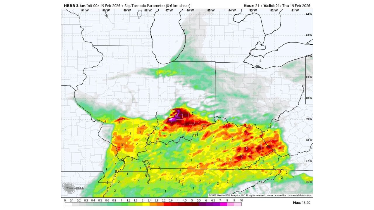
The latest HRRR 3km Significant Tornado Parameter (0–6 km shear) highlights a focused zone of enhanced tornado potential stretching from southern Illinois through central Indiana and into Kentucky and Tennessee.
The most intense values appear clustered near:
- Central Indiana, including areas near Indianapolis
- Western and central Kentucky, including Louisville
- Portions of northern Tennessee
Southern Illinois and western Kentucky also remain within the broader risk zone.
These elevated parameter values indicate a supportive environment for rotating thunderstorms capable of producing tornadoes if storms can fully develop.
Instability and Moisture Will Determine Severity
Forecasters note that tornado risk hinges heavily on how much instability and moisture increase through the day. If low-level moisture deepens ahead of the advancing front, storm intensity could rise quickly.
The afternoon heating window will be critical. Increased surface-based instability combined with strong wind shear could allow discrete cells to rotate efficiently.
If instability remains marginal, storm intensity may be limited, though even modest instability in a high-shear environment can still produce tornadoes.
Afternoon and Early Evening Most Concerning
The primary window for tornado development is expected from mid-afternoon through early evening, with storms possibly continuing into the overnight hours.
Communities across:
- Indianapolis, Indiana
- Louisville, Kentucky
- Evansville, Indiana
- Nashville, Tennessee
- Paducah, Kentucky
should remain weather-aware as storms begin organizing.
Forecast confidence supports the potential for a few tornadoes, particularly within stronger discrete storms ahead of the main line.
Multiple Tornadoes Possible — Not a Slam Dunk Day
Meteorologists emphasize that Thursday was never expected to be a “slam dunk” severe weather day. However, the absence of extreme instability does not eliminate tornado potential.
High-resolution convection-allowing models (CAMs) are largely consistent with previous expectations, showing rotating storm signatures across the highlighted corridor.
While not expected to be a large-scale outbreak, the environment supports the possibility of multiple isolated tornadoes, especially if storm cells remain semi-discrete.
Preparedness Is Critical Across the Ohio Valley
Residents across Illinois, Indiana, Kentucky, Tennessee, and southern Ohio are encouraged to:
- Ensure weather alerts are enabled
- Have multiple methods to receive warnings
- Review tornado safety plans
Because some storms may occur during the evening hours, quick access to warnings will be especially important.
As the Ohio Valley tornado threat continues evolving, ChicagoMusicGuide.com will provide ongoing updates on storm timing, intensity trends, and regional impacts. For continued severe weather coverage across the Midwest and Tennessee Valley, visit ChicagoMusicGuide.com.