
Illinois, Indiana, Ohio and Kentucky Face Dual Threat Thursday as Tornado Risk Targets Southern Indiana While Heavy Snow Buries Nebraska, Iowa, Minnesota and Wisconsin
KENTUCKY — A volatile late-winter system is setting up a dramatic weather divide across the Midwest and Ohio Valley on Thursday, bringing a tornado threat to parts of Illinois, Indiana, Ohio and Kentucky, while heavy accumulating snow targets Nebraska, Iowa, Minnesota and Wisconsin late Thursday into early Friday.
Forecast guidance shows two distinct hazards unfolding at the same time — severe storms on the warm side of the system and significant snow on the cold side.
Tornado Risk Focused on Southern Indiana, Eastern Illinois, Southwest Ohio and Northern Kentucky
Model projections valid Thursday afternoon and early evening indicate a conditional severe weather setup, particularly across:
- Eastern Illinois
- Southern Indiana
- Southwest Ohio
- Far Northern Kentucky
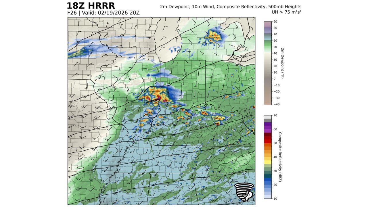
Southern Indiana appears to carry the highest concern, including areas near Terre Haute, Indianapolis, Evansville, Louisville and Covington.
The setup features a warm front draped across central Indiana and Ohio, with a cold front pushing eastward from Illinois and Missouri. This creates a potential triple-point environment — a classic configuration that can support rotating storms if instability and wind shear align properly.
If a discrete supercell develops, a briefly strong tornado (EF2+ possible) cannot be ruled out. Current outlook thinking aligns with a 5% tornado probability and 15% wind and hail risk, meaning this is not a widespread outbreak scenario — but it is one that must be monitored closely.
Damaging Winds and Hail Possible Across the Ohio Valley
Even where tornadoes do not materialize, thunderstorms could still produce:
- Wind gusts of 50–60 mph
- Large hail
- Intense downpours
Storm activity is expected to increase during the mid-to-late afternoon hours and push east into Ohio and northern Kentucky during the early evening.
Because this system is timing-dependent, small changes in storm initiation could significantly alter impact zones. Real-time radar trends Thursday afternoon will be critical.
Heavy Snow Targets Nebraska, Iowa, Minnesota and Wisconsin Late Thursday
On the northwest side of the system, colder air wraps in quickly, supporting a swath of heavy snow from:
- Central and eastern Nebraska
- Much of Iowa
- Southern and central Minnesota
- Northern and central Wisconsin
Guidance suggests several inches of accumulation are possible, especially where banding develops. The snowfall gradient appears sharp, meaning totals could vary significantly over short distances.
Major travel corridors including Interstate 80, Interstate 35 and Interstate 94 could experience reduced visibility and slick road conditions late Thursday night into Friday morning.
Rapid Temperature Drop Behind the Cold Front
Behind the system, a strong cold front will cause temperatures to fall rapidly — especially across the Ohio Valley. Areas experiencing near-record warmth earlier in the week could see a sharp transition to colder, gusty conditions by late Thursday night.
Wind chills will drop, and lingering moisture could freeze where temperatures fall quickly enough.
What This Means for the Broader Midwest and Chicago Region
For the Chicago area and surrounding Midwest communities:
- Rain and embedded thunderstorms are possible.
- Severe risk is higher southeast toward Indiana and Ohio.
- Snow potential increases northwest into Wisconsin and Iowa.
Chicago sits near the transition zone, meaning small track adjustments in the storm system could determine precipitation type locally.
Bottom Line: A Split-Personality Storm With Regional Impacts
This is a classic Midwest clash of air masses — tornado risk in parts of Illinois, Indiana, Ohio and Kentucky, and heavy snow across Nebraska, Iowa, Minnesota and Wisconsin.
Southern Indiana currently carries the greatest tornado concern, while the Upper Midwest prepares for accumulating snow and potential travel disruptions.
This remains a developing situation, and forecast updates are expected as the system approaches. Stay weather-aware Thursday afternoon and evening as this dynamic pattern unfolds.
For continued Midwest weather coverage and live updates, keep checking Chicagomusicguide.com.