
Illinois, Indiana, Ohio, and Michigan Face Gradual Snowpack Melting as Milder Weather Settles In This Week
CHICAGO, ILLINOIS — A stretch of near-average temperatures and increasing sunshine is expected to bring gradual snowpack melting across much of the Midwest and Great Lakes region this week, including Illinois, Indiana, Ohio, Michigan, and southern Wisconsin. Forecast data shows that while snow cover will begin to shrink, deep existing snowpack will slow the melting process, preventing a rapid thaw.
The result will be a steady erosion of snow rather than a sudden disappearance, especially north and east of Chicago.
Temperatures Trend Closer to Seasonal Averages
After an extended period of colder weather, temperatures across the region are forecast to moderate back toward seasonal norms. Daytime highs will be warm enough to encourage surface melting, particularly during afternoon hours when sunshine becomes more frequent.
Overnight lows, however, will remain cool enough in many areas to limit aggressive melting, allowing snowpack to refreeze at night and slow overall loss.
Snowpack Erosion Will Be Slow and Uneven
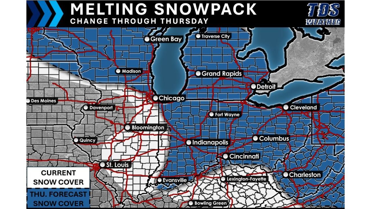
Snow cover maps show the deepest remaining snowpack across northern Illinois, northern Indiana, Michigan, and Ohio, while parts of Missouri, southern Illinois, and western Indiana have already seen more extensive melt.
Because of snow depth, melting will:
- Occur first on roads, rooftops, and south-facing surfaces
- Persist longer in shaded and rural areas
- Linger across northern counties and Great Lakes–adjacent regions
This uneven melting pattern means some areas will still look wintry even as others turn bare.
Why Snow Melts Slowly Despite Milder Air
Snowpack plays a major role in controlling temperature. Fresh and deep snow reflects sunlight, keeping surface temperatures cooler and delaying warming. As snow gradually melts and exposes darker ground, heat absorption increases, allowing warmer air to gain a better foothold later in the week.
This feedback effect explains why temperatures often rise more noticeably after significant snow cover disappears.
Impacts for Travel and Local Conditions
Gradual melting reduces the risk of widespread flooding, but localized issues remain possible:
- Standing water in low-lying areas
- Slushy conditions during the afternoon
- Refreezing at night on untreated surfaces
Drivers should remain alert, especially during early morning and late evening hours.
What to Expect Through Thursday
Forecast guidance suggests that by Thursday, snow cover will be noticeably reduced across:
- Central and southern Illinois
- Southern Indiana
- Parts of Ohio and western Michigan
However, northern sections of the Midwest and Great Lakes are expected to retain snowpack longer, especially where depth remains substantial.
Looking Ahead Beyond This Week
While this week favors melting, snowpack persistence will influence future temperature trends. If additional warm periods develop, melting will accelerate. If colder air returns, remaining snow could quickly stabilize or refreeze.
For now, the region appears locked into a gradual transition rather than a sudden thaw, keeping winter visible even as springlike influences begin to creep in.
As Illinois and the broader Midwest move through this slow melt phase, monitoring temperature swings and nighttime refreezing will be key. For continued Midwest weather updates, snowpack trends, and regional forecasts, visit ChicagoMusicGuide.com.