
Illinois, Michigan, Ohio, Pennsylvania and New York Face Potential Late-Week Winter Storm as Snow Targets Great Lakes and Appalachians
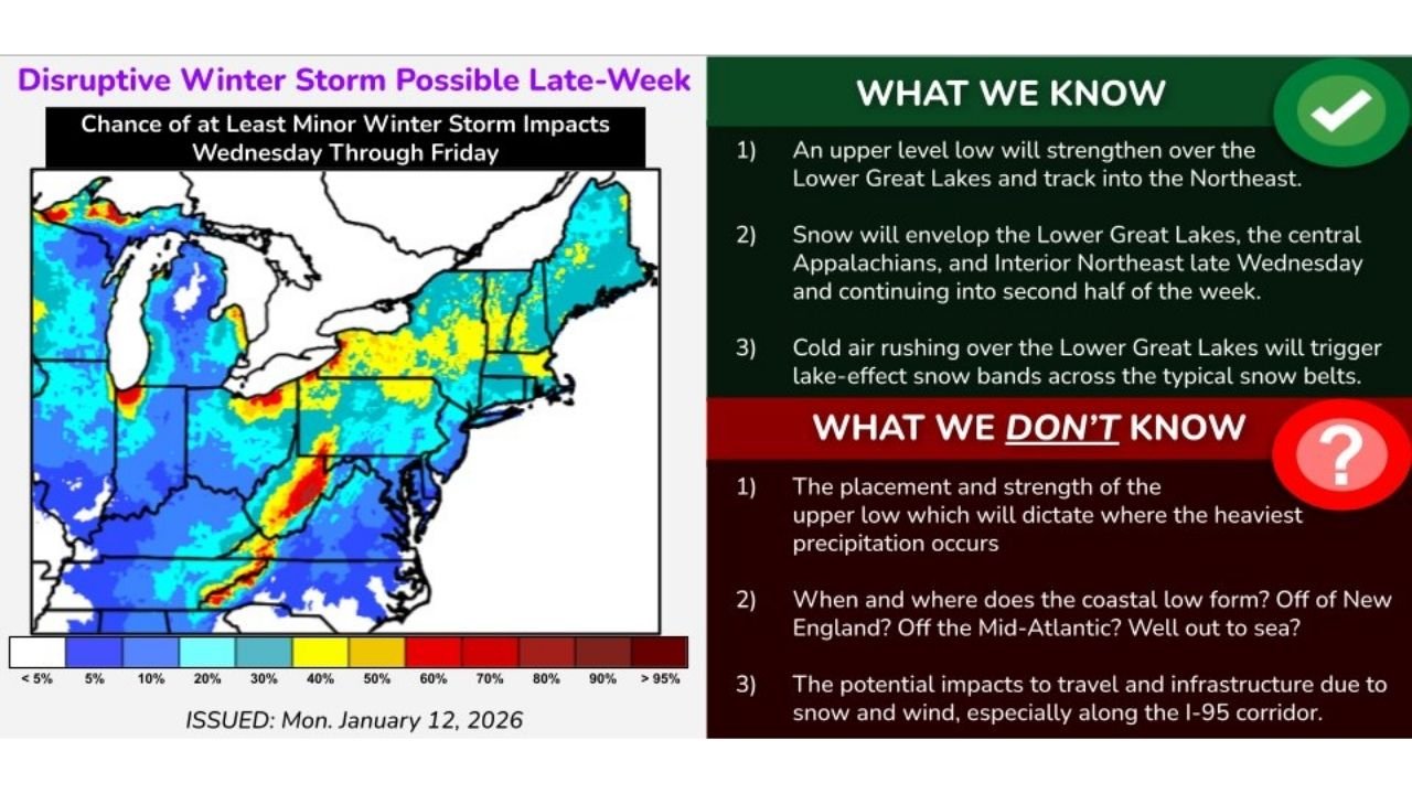
ILLINOIS – Forecast guidance from the National Weather Service’s Weather Prediction Center shows a developing winter storm system that could bring widespread snow across the Great Lakes, Central Appalachians, and parts of the Northeast starting Wednesday and lingering into Friday, though significant uncertainty remains about where the heaviest impacts will fall.
The system is being monitored closely due to its complex evolution, with multiple possible tracks still on the table. While confidence is growing that snow will occur across several states, exact placement, intensity, and travel impacts are not yet locked in.
What Forecasters Are Confident About So Far
Meteorologists agree on several key elements shown in the latest outlooks:
- An upper-level low pressure system is expected to strengthen over the Lower Great Lakes and track northeastward.
- Snow is likely to expand across Illinois, Michigan, Ohio, Pennsylvania, West Virginia, and interior New York beginning late Wednesday.
- Cold air spilling over the Great Lakes will likely trigger lake-effect snow bands, especially downwind of Lake Michigan and Lake Erie, where localized accumulations could exceed surrounding areas.
These lake-effect bands could lead to sharp snowfall contrasts, where some communities receive several inches while nearby areas see far less.
What Remains Uncertain and Could Change Quickly
Despite increasing confidence in snow, forecasters caution that several important details are still unresolved:
- The exact track and strength of the upper-level low, which will determine where the heaviest snow sets up.
- Whether a secondary coastal low develops off the Mid-Atlantic or New England coast, which could significantly boost snowfall farther east.
- The degree of wind involvement, which could create blowing snow and hazardous travel along major corridors, including parts of the I-90 and I-95 routes.
Because of these unknowns, snowfall totals and impact levels could shift notably over the next 24–48 hours.
Regional Impact Snapshot by State
- Illinois & Michigan: Periods of accumulating snow with enhanced lake-effect potential, especially near Lake Michigan.
- Ohio & Pennsylvania: Snow spreading eastward with potential for higher totals in elevated and lake-enhanced regions.
- New York: Interior sections may see prolonged snowfall, while outcomes depend heavily on storm track and coastal development.
At this stage, the Weather Prediction Center highlights the chance for at least minor winter storm impacts, rather than a guaranteed high-end event.
Why This Storm Is Being Watched Closely
This setup arrives during a period of very cold air, meaning even moderate snowfall could lead to icy roads, flight delays, and difficult commuting conditions. The lingering nature of the system also raises concerns about extended travel disruptions rather than a quick-hitting storm.
Forecasters stress that confidence will increase significantly as the storm draws closer, and residents across the Great Lakes and Northeast should monitor updated advisories through midweek.
Final Word for Readers
Winter weather hype is easy to find online, but this system remains a legitimate forecast concern backed by official guidance, not social-media speculation. While it is too early to pinpoint exact totals, conditions are aligning for a meaningful winter event across multiple states.
Stay alert for updated forecasts, especially if you have travel plans later this week.
What do you think — will this system deliver a widespread winter storm or remain a patchy, lake-effect-driven event? Share your thoughts and keep following ChicagoMusicGuide.com for clear, data-driven weather updates tied to major events and regional impacts.