
Illinois, Missouri, Indiana, Kentucky and Ohio Were Ground Zero for a 70-Tornado Outbreak That Exploded Across 11 States in Just 24 Hours
ILLINOIS — February 28 to March 1, 2017 remains one of the most explosive early-season severe weather outbreaks in Midwest and Ohio Valley history, as nearly 70 tornadoes tore across 11 states in just 24 hours.
The event carved a destructive corridor from Missouri through Illinois, Indiana, Kentucky and into Ohio, producing widespread damage, dozens of injuries and multiple fatalities. The strongest tornado of the outbreak — an EF4 — leveled homes near Perryville, Missouri, marking one of the most intense tornadoes ever recorded in the region during the month of February.
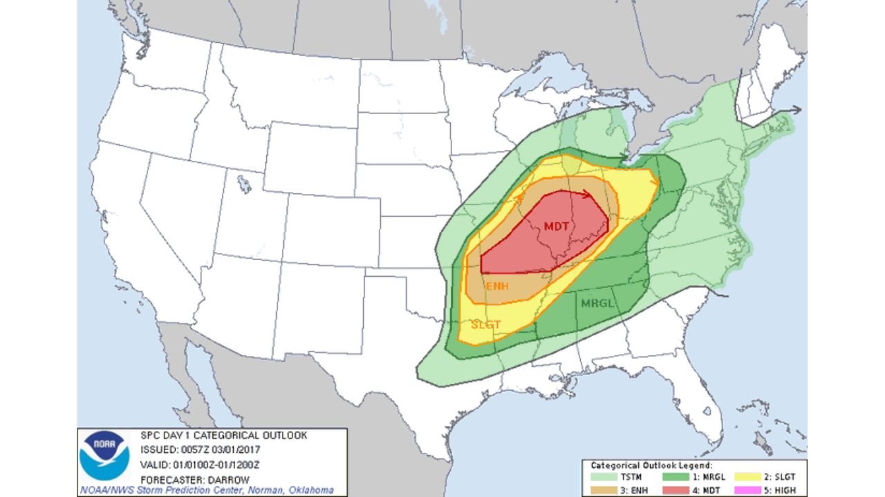
A Rare High-End Risk Across the Midwest and Ohio Valley
Storm Prediction Center outlook maps from that day show a rare, expansive moderate to enhanced risk area stretching from eastern Missouri and Illinois through Indiana, Kentucky and Ohio.
A clearly defined “strong to violent tornado corridor” was highlighted across:
- Southeast Missouri
- Southern Illinois
- Western Kentucky
- Southern Indiana
- Southwest Ohio
This wasn’t a typical scattered severe weather day — this was a focused, high-impact outbreak zone.
Nearly 70 Tornadoes Confirmed in 24 Hours
Preliminary SPC filtered storm reports documented:
- 72 tornado reports
- Over 300 wind reports
- Nearly 200 hail reports
- More than 550 total severe reports
The most concentrated tornado activity clustered across:
- Missouri
- Illinois
- Indiana
- Kentucky
- Ohio
Radar and archive track data show multiple long-track supercells moving northeast across the Mississippi and Ohio River Valleys during peak evening hours.
Missouri’s EF4: The Most Violent Tornado of the Outbreak
The strongest tornado of the event struck near Perryville, Missouri, rated EF4 on the Enhanced Fujita scale.
That tornado:
- Leveled well-constructed homes
- Caused catastrophic structural damage
- Produced fatalities and numerous injuries
Its track sits prominently within the outlined high-risk corridor shown on archived maps.
Illinois and Indiana See Multiple Tornado Tracks
Illinois experienced several confirmed tornadoes, particularly across southern and central portions of the state.
Indiana saw multiple tornado tracks extending through southwestern and central counties, with damage reports stretching toward the Indianapolis metro region.
Archived Tornado Archive maps show clusters of EF1-EF3 tornadoes embedded within the broader outbreak footprint.
Kentucky and Ohio Also Hit Hard
Western and central Kentucky saw repeated supercell passages capable of producing strong tornadoes.
Parts of Ohio, particularly southwestern sections, were impacted as storms tracked northeast into the overnight hours.
The outbreak produced:
- 69 confirmed tornadoes
- 4 fatalities
- 45 injuries
according to archive summaries tied to the event.
Why This Outbreak Was So Dangerous
Several ingredients aligned simultaneously:
- Strong wind shear
- Unseasonably warm and humid air surging north
- A powerful upper-level system ejecting from the Plains
The setup created a textbook environment for long-lived, rotating supercells across the Midwest and Ohio Valley.
What made it especially dangerous was the timing — many tornadoes occurred after dark, increasing risk to residents.
A Historic Late-Winter Severe Weather Benchmark
The February 28–March 1, 2017 outbreak remains one of the most significant early-season tornado events on record for:
- Missouri
- Illinois
- Indiana
- Kentucky
- Ohio
It serves as a reminder that tornado season in the Midwest and Ohio Valley can begin well before spring officially arrives.
For weather enthusiasts and residents alike, it stands as a case study in how quickly conditions can escalate from warm late-winter air to widespread severe weather in a matter of hours.
Stay with ChicagoMusicGuide.com for more historical severe weather breakdowns and regional climate analysis.