
Illinois Severe Weather Threat Builds Thursday: Eastern Illinois Into Indiana Faces Stronger Risk While Northern Illinois Could See Triple-Point Surprise
ILLINOIS, UNITED STATES — Forecasters are highlighting two distinct areas of concern for Thursday’s severe weather threat, with the primary focus on eastern Illinois into Indiana, and a secondary, more conditional risk across northern Illinois. Current data suggests stronger instability south and east of Chicago, though a locally higher severe threat could develop farther north if atmospheric conditions align.
Model guidance indicates that storm intensity will depend heavily on instability recovery and morning convection trends, especially across central and northern parts of the state.
Eastern Illinois Into Indiana Emerges as the More Straightforward Severe Corridor
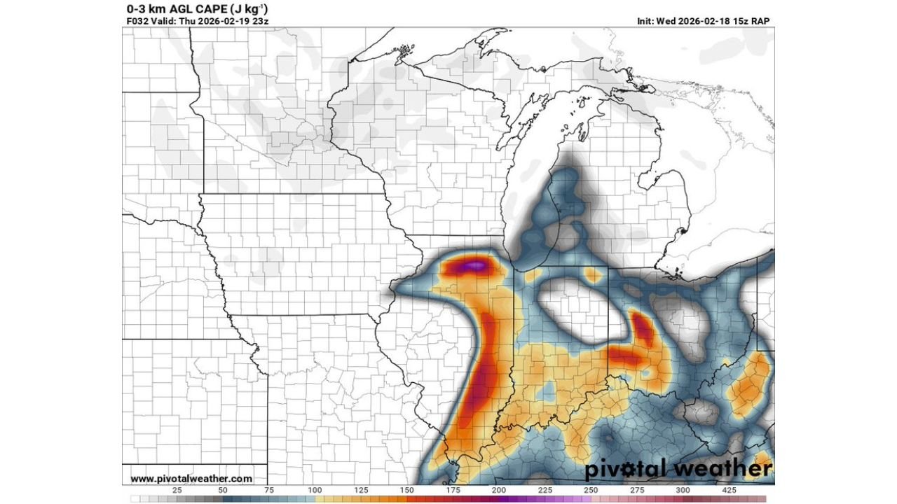
The corridor stretching from east-central Illinois into western Indiana currently appears to be the more organized severe setup. Forecast data shows higher low-level instability (0–3 km CAPE values exceeding 175–200 J/kg) in this zone, signaling the potential for stronger storm updrafts.
The most notable pocket of enhanced instability is centered near the Illinois-Indiana border, where deeper moisture and warmer air are expected to overlap during peak heating. This alignment increases the likelihood of thunderstorms capable of producing damaging wind gusts and possibly isolated tornadoes, depending on storm structure.
Meteorologists describe this region as the more “straightforward” severe area because instability is expected to be more robust and less dependent on recovery factors.
Northern Illinois Threat Hinges on Morning Convection
Across north-central and northern Illinois, including areas closer to Chicago, the severe weather outlook is more conditional. The risk depends heavily on how quickly the atmosphere can destabilize following early-day cloud cover or storms moving through southern portions of the state.
If sufficient clearing occurs and instability rebounds by afternoon, storms developing near the triple-point region — where warm, cold, and occluded fronts intersect — could intensify quickly.
This setup is particularly noteworthy because triple-point systems can locally enhance wind shear and low-level rotation, creating an environment favorable for stronger storms despite broader uncertainty.
RAP Model Signals Notable Instability and Moisture Surge
The 15Z RAP model highlights a concentrated plume of instability arcing from southern Illinois northward into eastern Illinois, with stronger low-level CAPE values near the Illinois-Indiana border. Meanwhile, dew point projections show mid-to-upper 50s Fahrenheit moisture pooling into central and eastern Illinois, providing the fuel necessary for organized convection.
Sounding data also indicates sufficient wind shear profiles to support structured storms, including supercell potential if discrete development occurs ahead of any larger storm clusters.
While the highest instability remains south and east of the Chicago metro area, forecasters caution that subtle shifts in frontal placement could bring stronger storms farther north.
What Makes the Northern Illinois Setup Potentially Dangerous
Even though northern Illinois is considered the secondary zone, meteorologists point out that it could become a locally enhanced severe pocket if destabilization occurs. In triple-point scenarios, convergence along frontal boundaries can focus storm initiation in a narrow corridor, increasing the chance of rotating storms.
If enough surface heating develops during the afternoon hours, parts of north-central Illinois could see rapidly intensifying thunderstorms capable of strong wind gusts or brief tornado spin-ups.
The uncertainty lies in whether early convection downstate limits instability across the northern half of Illinois.
Timing and Potential Impacts
The most likely window for stronger storms appears to be Thursday afternoon into early evening, particularly across eastern Illinois into Indiana. Northern Illinois would likely see activity later in the day if atmospheric recovery occurs.
Primary hazards may include:
- Damaging straight-line winds
- Large hail
- Isolated tornado potential, especially near frontal intersections
Residents across Illinois — particularly those in east-central Illinois, the Illinois-Indiana border region, and northern Illinois — should closely monitor updated forecasts as mesoscale details become clearer.
Forecast adjustments are possible depending on early-day storm activity and frontal positioning.
As Illinois enters a potentially volatile severe weather setup, staying informed and prepared remains essential. For continued updates on storm threats, severe weather timing, and regional impacts across Illinois and the Midwest, visit ChicagoMusicGuide.com.