
Illinois, Wisconsin, Michigan, and Minnesota Brace for January Cold as Texas, Florida, and Georgia Trend Warmer Than Average
UNITED STATES — A new January temperature outlook indicates a sharp regional divide across the country, with persistent cold expected across the Midwest and Great Lakes, while much of the South and Southwest trends warmer than average as the month progresses. Forecast signals also suggest the second half of January could turn significantly colder than the first, particularly across the northern tier.
The outlook highlights how large-scale atmospheric patterns may shape temperature trends well beyond the first week of the month.
Midwest and Great Lakes Face Prolonged Cold Pattern
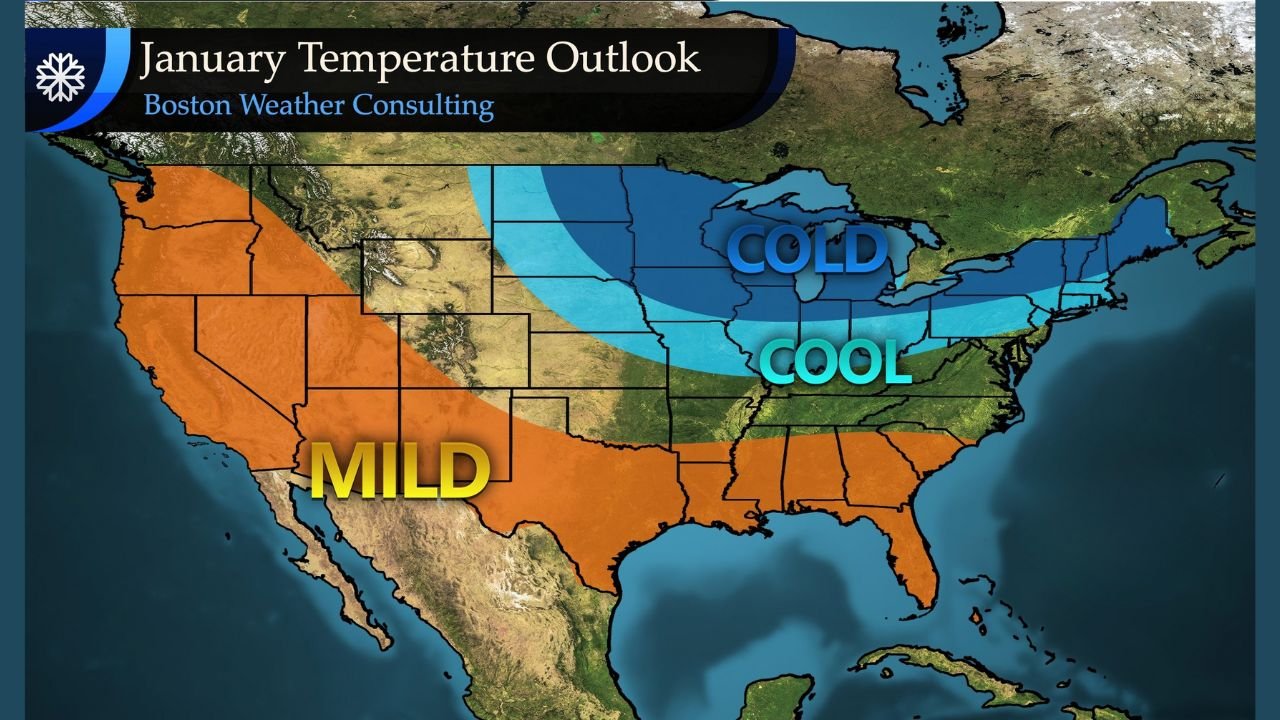
The core of the cold air is forecast to remain locked across the Midwest, extending through states such as Illinois, Wisconsin, Michigan, Minnesota, Iowa, and northern Indiana. The temperature anomaly shading on the outlook shows these areas firmly in the “cold” category, not just briefly but as a sustained pattern.
This suggests frequent cold shots, limited warm-ups, and a higher likelihood of below-average daytime highs, especially during the second half of January, when colder air may reinforce across the region.
Northeast and Ohio Valley Trend Cool, Not Extreme
Across the Ohio Valley and Northeast, including Ohio, Pennsylvania, New York, and parts of New England, the outlook leans cool rather than extreme cold. These areas are positioned on the southern edge of the primary cold pool, meaning temperatures may fluctuate with short warm intrusions followed by colder periods.
This pattern supports seasonable to below-average temperatures, but not the persistent deep freeze expected farther west in the Midwest.
Southeast States Likely Warmer Than Average
In contrast, the Southeastern United States — including Florida, Georgia, Alabama, Mississippi, South Carolina, and parts of Tennessee — is projected to experience above-average temperatures for much of January.
This warmer trend is linked to a Southeast ridge pattern, which allows milder air to dominate the region. While brief cold fronts are still possible, the overall signal favors more spring-like stretches, especially during the first half of the month.
Southwest and Southern Plains Stay Mild
The Southwest and Southern Plains, covering California, Arizona, New Mexico, Texas, and southern Nevada, are also highlighted in the mild category. This suggests fewer cold outbreaks and above-average temperatures, particularly across desert and lower-elevation regions.
This pattern aligns with a broader west-to-east temperature gradient, where colder air struggles to push deep into the southern tier.
Second Half of January May Turn Sharply Colder
One of the most notable signals from the outlook is the potential shift later in January, when colder air could expand southward again, reinforcing cold conditions across the Midwest and northern Plains.
While confidence decreases at longer lead times, the data supports a much colder second half of the month compared to the first, especially for states already positioned under the cold core.
What This Pattern Means Going Forward
This setup increases the likelihood of:
- Extended cold stretches in the Midwest and Great Lakes
- Temperature volatility in the Ohio Valley and Northeast
- Prolonged mild conditions across the South and Southwest
Any major storm systems later in January could also interact with this temperature gradient, increasing the potential for impactful winter weather where cold air is entrenched.
Weather patterns are evolving, and adjustments are likely as January unfolds. What are you seeing where you live — colder than normal, or feeling that early-month warmth? Share your observations and stay connected with ChicagoMusicGuide.com for continued weather analysis and updates.