
Indiana, Ohio, Kentucky, West Virginia, and Pennsylvania in Crosshairs as Sunday Severe Storm Threat Brings Damaging Winds, Large Hail, and Isolated Tornado Risk
INDIANAPOLIS, INDIANA — Severe weather is likely to develop Sunday afternoon and evening across portions of Indiana, Ohio, Kentucky, West Virginia, and Pennsylvania, provided the atmospheric cap erodes as forecast. Meteorologists indicate that damaging winds and large hail are the most probable hazards, though a few tornadoes cannot be ruled out, particularly if any storms remain discrete.
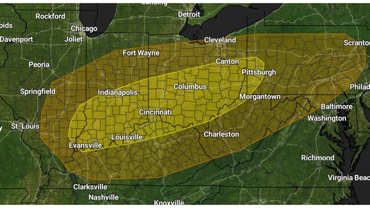
The highlighted risk corridor stretches from southern Indiana and Kentucky northeast through central Ohio into western Pennsylvania, encompassing major cities such as Indianapolis, Louisville, Cincinnati, Columbus, Pittsburgh, and Morgantown.
Cap Erosion Key to Storm Intensity
Forecasters emphasize that storm development hinges on the weakening of a mid-level cap, a layer of warm air aloft that can suppress thunderstorm growth. If this cap fully erodes Sunday afternoon, thunderstorms are expected to form along an advancing boundary.
Should storms initiate early enough and remain isolated, supercell structures may develop. Discrete supercells are more capable of producing large hail and brief tornadoes, particularly in environments with sufficient wind shear.
However, if storms form later or quickly merge into clusters, the severe threat may shift toward a widespread damaging wind event.
Damaging Winds and Large Hail Most Likely
Current projections indicate that damaging straight-line winds and large hail are the primary concerns across the Ohio Valley and portions of the Mid-Atlantic.
Large hail is most likely during the early stages of storm development when updrafts are strongest. As storms mature and consolidate into lines or bowing segments, the wind threat typically becomes dominant.
Communities from Evansville and Louisville through Cincinnati and Columbus to Pittsburgh and Scranton should remain alert during the late afternoon and evening hours.
Tornado Risk Conditional but Present
While not the primary hazard, forecasters note that isolated tornadoes are possible if storms remain discrete long enough to rotate.
Low-level moisture is adequate but not overly abundant, which introduces some uncertainty. The tornado threat will depend heavily on storm mode — whether storms stay isolated or quickly organize into a line.
Residents in southern Ohio, northern Kentucky, western West Virginia, and western Pennsylvania should monitor updates closely, especially if warnings are issued.
Timing and Impact Window
The most likely window for severe weather appears to be Sunday afternoon into early nighttime hours, beginning in Indiana and Kentucky before shifting eastward into Ohio, West Virginia, and Pennsylvania.
If the cap erodes earlier than expected, storms could become more intense and isolated. If erosion is delayed, storms may still produce severe winds but with a more linear structure.
Forecasters stress that even with some uncertainty, the setup supports at least scattered severe storms across the region.
As the Ohio Valley and surrounding states prepare for Sunday’s developing storm system, residents are encouraged to review severe weather safety plans and remain weather-aware. For continued updates on severe weather outlooks, storm timing, and regional impacts, visit ChicagoMusicGuide.com.