
Indiana Tornado Threat Targets Indianapolis to Columbus Corridor Thursday Afternoon as StormNet Highlights Focused Risk Zone
INDIANA, UNITED STATES — A focused tornado threat area has been identified for Thursday afternoon, with the highest concern centered from Indianapolis south and southeast toward Columbus, Indiana. Forecast guidance indicates that while overall probabilities are not extreme, a few tornadoes are possible between 3:00 PM and 4:00 PM EST, particularly within a defined corridor of enhanced instability.
The threat is expected to shift south and east later in the evening as storms progress across the Ohio Valley.
StormNet Pinpoints Specific Afternoon Tornado Window
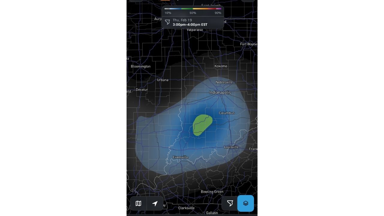
According to the StormNet outlook displayed via high-resolution radar guidance, the most favorable timeframe for tornadic development is Thursday from 3:00 PM to 4:00 PM EST. The highlighted zone includes areas just south of Indianapolis, extending toward Columbus, and reaching westward in the direction of Bloomington and Evansville.
A concentrated green-shaded area embedded within a broader blue risk region suggests locally enhanced tornado potential compared to surrounding areas. This indicates a focused pocket where atmospheric ingredients may align more efficiently for rotating storms.
Forecasters caution that while this is not considered a high-end outbreak setup, the environment supports at least isolated tornado development.
Geographic Breakdown of the Threat Zone
The broader risk envelope covers much of central and southern Indiana, including:
- Indianapolis
- Columbus
- Bloomington
- Evansville
- Areas north of Louisville, Kentucky
The more concentrated tornado corridor appears centered southeast of Indianapolis, particularly between Indianapolis and Columbus. Communities within this zone should be prepared for rapidly developing storms capable of rotation.
Farther north toward Fort Wayne and west toward Urbana and Decatur, the tornado signal weakens significantly.
Why This Setup Deserves Attention
Even though probabilities are described as “not super high,” the presence of a defined tornado zone suggests that at least a few storms could acquire strong low-level rotation. Afternoon heating combined with favorable wind shear may allow supercell structures to briefly form before storms merge or shift eastward.
Additionally, storm chasers monitoring the system note potential for well-structured storms, a sign that vertical wind profiles may support organized convection.
The environment appears supportive of storms initially forming in central Indiana before tracking southeast later in the day, pushing the severe threat toward southern Indiana and possibly western Kentucky by evening.
Threat Shifts South and East After Peak Window
As the afternoon progresses beyond the 3–4 PM EST window, the tornado risk is expected to migrate south and east. Areas closer to the Indiana-Kentucky border, and possibly into parts of western Ohio, could see continued severe activity depending on storm evolution.
Residents across central and southern Indiana should remain weather-aware during the afternoon hours, especially those in the Indianapolis-to-Columbus corridor, where the tornado signal is strongest.
While this is not projected to be a widespread tornado outbreak, isolated tornadoes and damaging winds remain possible, and conditions can change quickly in these types of focused setups.
As Indiana prepares for a potentially volatile afternoon, staying informed and having multiple ways to receive weather alerts will be critical. For continued severe weather coverage across Indiana and the Midwest, visit ChicagoMusicGuide.com for the latest updates and forecast developments.