
Kankakee Illinois Tornadic Supercell Unleashed Violent Tornadoes and Giant Hail Across Illinois and Indiana in Rare Dual Threat Event
KANKAKEE, ILLINOIS — A powerful and highly unusual tornadic supercell that developed on March 10 is now being closely analyzed by meteorologists, as new insights reveal how the storm produced both significant tornadoes and destructive, giant hail simultaneously across northeast Illinois into northwest Indiana.
The storm, centered near Kankakee, Bourbonnais, Bradley, and moving toward Momence and into Indiana, stands out as one of the more complex severe weather setups of the early spring season.
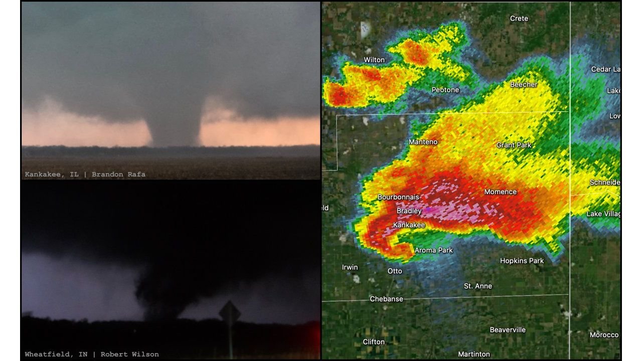
Radar Shows Explosive Supercell Structure Over Kankakee Region
High-resolution radar imagery captured the storm intensifying rapidly over Kankakee County, with a classic supercell signature emerging as it tracked northeast.
The most intense core of the storm—highlighted by deep red and pink reflectivity—was centered over:
- Kankakee
- Bourbonnais
- Bradley
- Momence
This region likely experienced the most extreme hail, with radar suggesting the presence of very large hailstones, potentially exceeding severe criteria.
Meanwhile, additional storm cells developed to the north near Peotone, Beecher, and Wilton Center, indicating a broader unstable environment supportive of multiple severe thunderstorm structures.
Tornado Production Extends Into Northwest Indiana
As the supercell tracked east-northeast, it maintained strong rotation, allowing tornado activity to continue beyond Illinois and into northwest Indiana, including areas near Wheatfield.
Visual reports confirmed a well-defined tornado on the ground, with a wide condensation funnel extending from the cloud base to the surface—signaling a mature and dangerous circulation.
This long-lived rotation highlights the storm’s ability to sustain organized mesocyclone dynamics, a key factor in prolonged tornado production.
Rare Combination: Giant Hail and Tornadoes Occurring Together
What makes this storm particularly notable is the simultaneous occurrence of two high-end severe weather threats:
- Large to giant hail driven by an intense updraft
- Strong tornadoes supported by persistent low-level rotation
Typically, storms favor one dominant hazard, but in this case, atmospheric conditions allowed both to thrive at once.
Strong instability, combined with favorable wind shear profiles across northeast Illinois and northwest Indiana, created an environment where the storm could sustain:
- Powerful updrafts capable of suspending large hailstones
- Strong rotation near the surface capable of producing tornadoes
Meteorologists Highlight Rapid Changes in Storm Behavior
Experts are now focusing on how quickly the storm evolved, with particular attention on sudden shifts in structure and intensity that enhanced its severe potential.
The transition from a standard thunderstorm into a highly organized tornadic supercell occurred over a relatively short timeframe, catching attention for its efficiency in producing multiple hazards.
This kind of behavior underscores how volatile early-season setups can be across the Midwest, especially when warm, moist air collides with lingering seasonal boundaries.
Impact Zone Covered Multiple Communities Across Two States
The storm’s path placed several communities directly in its impact zone, including:
- Kankakee, Bourbonnais, Bradley (Illinois)
- Momence and surrounding eastern Kankakee County areas
- Wheatfield and nearby northwest Indiana communities
Residents in these areas faced rapidly changing conditions, with tornado warnings and severe thunderstorm warnings occurring simultaneously.
A Case Study in Midwest Severe Weather Complexity
This March 10 event is shaping up to be a case study for meteorologists, offering insight into how supercells can evolve to produce multiple extreme hazards at once.
With a full meteorological breakdown expected later this week, including expert analysis and guest insights, this storm will likely contribute valuable data toward understanding dual-threat severe weather systems.
As spring severe weather season ramps up, events like this serve as a reminder of how quickly conditions can escalate across Illinois and Indiana.
For continued updates and in-depth weather analysis, stay with ChicagoMusicGuide.com.