
Kansas, Nebraska, Iowa, and Missouri See Unseasonably Warm January Surge as Gulf Coast and Great Lakes Stay Cooler
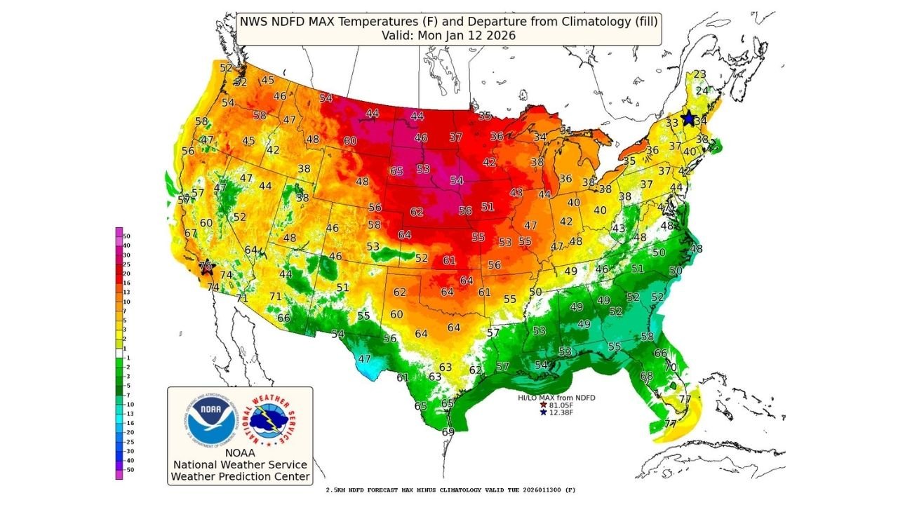
United States — A calm but highly unseasonable weather pattern is setting up across much of the central and northern United States, with the Heartland emerging as the warmest region to start the week. Forecast data shows parts of Kansas, Nebraska, Iowa, Missouri, and surrounding Midwest states running 25 to 30 degrees above January averages, while cooler conditions persist closer to the Gulf Coast and Great Lakes.
National Weather Service temperature outlooks valid for Monday, January 12, 2026, confirm this sharp contrast, driven by a broad area of high pressure dominating the Plains and Midwest.
Heartland Leads the Nation in January Warmth
The warmest anomalies are centered across the central Plains and Midwest, where afternoon highs are projected to climb into the 50s and low 60s, levels more typical of early spring than mid-winter. Forecast maps show the most significant departures from normal over Nebraska, Kansas, Iowa, South Dakota, and Missouri, where temperatures are running well above climatological averages.
This warmth is the result of southerly flow on the western side of high pressure, allowing mild air to surge northward and suppress typical winter cold. With little storm activity nearby, skies remain mostly quiet, further supporting daytime warming.
Cooler Pockets Along the Gulf Coast and Great Lakes
While much of the interior enjoys a break from winter cold, the Gulf Coast states, including Texas, Louisiana, Mississippi, Alabama, and Florida, remain comparatively cooler. Cloud cover and lingering frontal boundaries are keeping temperatures closer to seasonal norms, particularly along coastal areas.
Meanwhile, the Great Lakes region, especially areas east of Lake Ontario in New York, continues to see lake-effect snow, as colder air moves across the relatively warmer lake waters. These localized snow bands stand in stark contrast to the springlike warmth dominating the Plains.
Rain and Snow Remain Limited Nationally
Precipitation across the country is generally light and confined. Forecast guidance shows rain mainly limited to parts of Washington State, while mixed precipitation and light snow linger in the Upper Midwest and Great Lakes.
Elsewhere, the strong high-pressure system keeps most of the nation dry, reinforcing the calm weather pattern and allowing temperature anomalies to take center stage.
What This Pattern Signals Going Forward
While the warmth is notable, forecasters caution that January patterns can change quickly. The same quiet setup that allows warmth to build can also break down rapidly if Arctic air pushes south later in the month. For now, however, the central U.S. is enjoying one of the mildest stretches of the winter season.
Residents are encouraged to enjoy the break but remain aware that winter is far from over, especially in northern states prone to sudden temperature swings.
For continued weather coverage, regional outlooks, and updates that matter to travelers and event planners, visit ChicagoMusicGuide.com for the latest forecasts and developing weather stories.