
Late-March Pattern Flip? ECMWF EPS Signals Expanding Cold Risk Across Midwest, Great Lakes and Northeast While Western U.S. Turns Much Warmer
UNITED STATES — A new long-range ensemble outlook is hinting at a notable temperature split across the country during the latter part of Week 2, with colder risks expanding across the Midwest, Great Lakes, and Northeast, while the Western United States heats up significantly above normal.
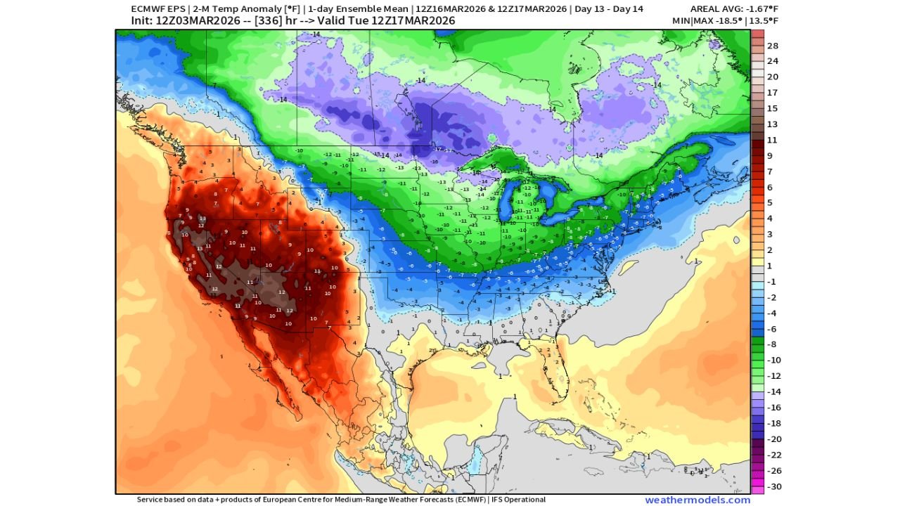
The latest ECMWF EPS (European ensemble) temperature anomaly guidance valid around March 16–17 shows a broad swath of below-average temperatures stretching from the northern Plains through the Ohio Valley and into the Mid-Atlantic and New England.
Colder Risks Expanding Across the Northern Tier
The most pronounced cold anomalies appear centered over:
- North Dakota, South Dakota, and Minnesota
- Wisconsin and Michigan
- Portions of Iowa, Illinois, Indiana, and Ohio
- Extending into parts of the Northeast
Temperature departures in the northern Plains and Upper Midwest are depicted as significantly below average, with anomalies deepening across southern Canada and spilling southward into the United States.
For cities like Chicago, Milwaukee, Minneapolis, Detroit, and Cleveland, this could mean a renewed period of colder-than-normal conditions during what is typically a transition toward spring warmth.
Great Lakes and Midwest in the Core of the Cool Zone
The ensemble mean suggests a coherent cold pool centered near the Upper Midwest and Great Lakes, with widespread below-normal readings also projected across:
- Missouri
- Illinois
- Indiana
- Ohio
- Parts of Pennsylvania and New York
While exact temperature values will evolve, the pattern implies a late-season chill that could delay springlike warmth across much of the central and eastern U.S.
Southern States: Marginally Cool to Near Normal
Across the Tennessee Valley, Deep South, and Gulf Coast, anomalies appear closer to seasonal norms, though some modest below-average signals extend into portions of:
- Arkansas
- Tennessee
- Kentucky
- The Carolinas
This suggests that the coldest air remains focused farther north rather than plunging deeply into the Southeast.
Western U.S. Trends Much Warmer
In stark contrast, the map shows strong positive temperature anomalies across:
- California
- Nevada
- Arizona
- Utah
- Portions of Oregon and Washington
The western half of the country is projected to run well above average, with the most intense warmth concentrated across the interior Southwest and Great Basin.
This east-west temperature gradient indicates a large-scale pattern featuring troughing over the eastern U.S. and ridging across the West.
What This Means for Chicago and the Midwest
For the Chicago area and surrounding Midwest communities, the ensemble guidance suggests:
- Increased risk of below-normal temperatures late Week 2
- Potential for extended chilly conditions rather than a brief cool snap
- Slower progression into consistent spring warmth
While this is not necessarily indicative of a major Arctic outbreak, it does point toward a broader, more sustained cooler regime developing.
Important Caveat: It’s Still Week 2
Long-range ensemble forecasts are designed to highlight pattern trends rather than precise day-to-day temperatures. Confidence increases in broad signals, but details regarding exact highs, lows, and precipitation remain uncertain at this range.
However, the consistency of the colder signal across multiple ensemble members suggests that the risk of a cooler pattern is worth monitoring.
Bottom Line
The ECMWF EPS ensemble is signaling a developing late-March temperature divide, with colder-than-normal conditions spreading across the Midwest, Great Lakes, and Northeast, while the Western United States trends significantly warmer.
For Chicago and much of the central U.S., this could mean a delayed warmup as we approach mid-March.
ChicagoMusicGuide.com will continue tracking evolving long-range signals as the spring pattern battle between western warmth and eastern chill takes shape.