
Life-Threatening Cold Targets Washington, D.C., Maryland, Virginia, and West Virginia With Wind Chills as Low as -40 Through Sunday Morning
WASHINGTON, D.C. — A surge of dangerous, life-threatening cold is set to move into the DMV region from Saturday morning through Sunday morning, bringing some of the coldest air of the season in the wake of an Arctic front. Extreme Cold Warnings and Cold Weather Advisories are in effect across the entire DMV, with wind chills expected to plunge well below zero for an extended stretch.
The cold snap is expected to be prolonged, with wind chill values below 0°F for more than 24 hours in many communities. Forecasters are warning that exposure without proper layers could lead to hypothermia and frostbite on exposed skin in as little as 30 minutes.
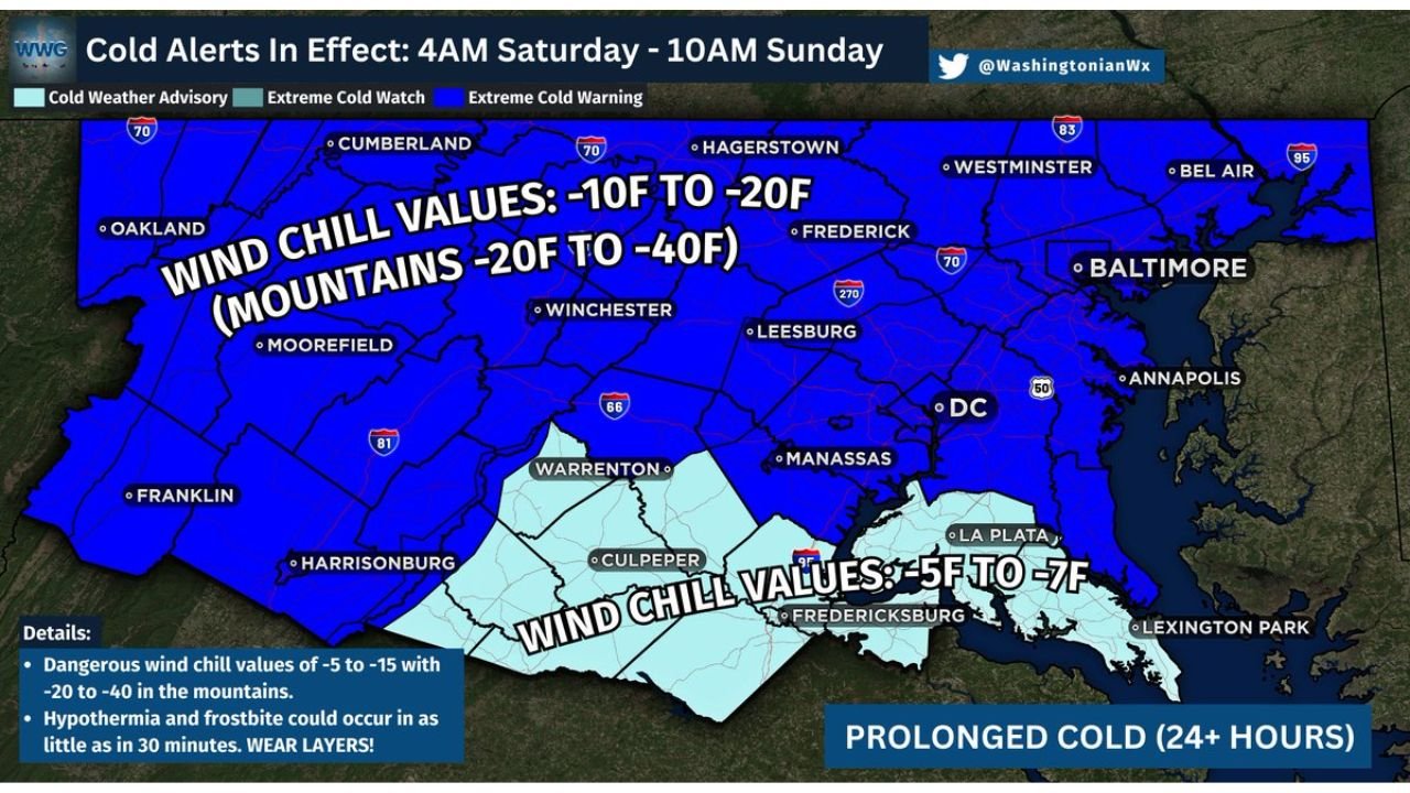
Cold Alerts and Timing: Saturday Morning Through Sunday Morning
The alert window shown on the map runs from 4:00 AM Saturday to 10:00 AM Sunday, covering population centers across Washington, D.C., Maryland, Virginia, and nearby areas. This is not a brief overnight dip—conditions are expected to remain harsh through Saturday, Saturday night, and into Sunday morning, with the worst wind chills peaking during the coldest hours and continuing even during daytime.
The most widespread concern is the duration. When wind chills stay below zero for long periods, the risk increases for anyone commuting early, working outdoors, waiting for rides, or moving between venues and parking areas. Even short trips outside can become dangerous if skin is exposed or clothing is inadequate.
The map also highlights how broad the cold footprint is, stretching from western zones like Oakland, Moorefield, and Franklin toward metro areas including Baltimore, Annapolis, Frederick, Hagerstown, and Washington, D.C.—a sign that almost everyone in the region will feel the impact.
Wind Chill Forecast: -5 to -15 for Many, -20 to -40 in Mountain Areas
The core warning is the wind chill numbers. Much of the region is projected to see wind chills as low as -5°F to -15°F, with mountain zones potentially dropping into a much more dangerous range of -20°F to -40°F. That kind of cold can cause frostbite rapidly and makes it difficult for the body to maintain heat, especially during any prolonged outdoor exposure.
Areas in the colder, higher-risk wind chill zone include much of the broader interior region stretching toward western and higher terrain sections, where the map explicitly calls out the most extreme values. Meanwhile, a lighter-shaded zone still shows significant cold—around -5°F to -7°F—covering parts of southern and southeast-adjacent areas shown near Fredericksburg, La Plata, and Lexington Park.
Even within the “less extreme” category, those values are still dangerous. Wind-driven cold strips heat quickly, meaning the difference between discomfort and injury can come fast—especially if gloves, hats, face coverings, and insulated footwear are missing.
Why This Cold Snap Is Being Compared to Rare Past Events
The impact statement attached to the alert notes that some locations have not experienced prolonged cold like this in roughly 30 years, pointing to a historic comparison period of January 15–16, 1994. That’s a key signal of severity—not just cold temperatures, but sustained cold that lingers long enough to affect infrastructure, travel reliability, and safety outcomes across an entire region.
When an Arctic outbreak is both intense and long-lasting, risks extend beyond frostbite. Pipes can freeze more easily, vehicle batteries struggle, and any loss of heat becomes a bigger emergency. For households, that means taking preventive steps early—especially if you live in a drafty building, rely on space heaters, or have pets and vulnerable family members.
This is also why officials emphasize layering instead of relying on a single heavy coat. Multiple insulating layers help trap heat and reduce the chance of wind cutting through clothing.
Power Outage Potential and Safety Steps for Homes, Pets, and Event Travel
The alert also flags the possibility of power outages due to strong to damaging winds, which can sharply worsen the dangers of extreme cold. In an outage scenario, indoor temperatures can fall quickly, and the health risks rise—especially overnight. If you are in an area prone to outages, charging devices, prepping blankets, and having a safe backup heat plan becomes more important.
Key safety steps emphasized in the message include wearing several layers, limiting time outdoors, and keeping pets indoors as much as possible. Cover exposed skin, avoid long waits outside, and check on neighbors who may not have reliable heat or transportation.
For weekend plans in the Washington, D.C. and Baltimore, Maryland nightlife corridors—and in nearby Virginia hubs like Leesburg, Manassas, Winchester, and Harrisonburg—the biggest risk may come from being outside longer than expected: waiting in lines, walking between venues, or dealing with delayed rides. If you must go out, shorten outdoor exposure, keep extra layers in the car, and plan for the cold to feel significantly worse than the thermometer suggests.
As the DMV braces for wind chills that can drop as low as -40°F in mountain areas and remain below zero for extended periods, preparation and timing matter as much as the forecast itself. For more Weather updates that help you plan around shows, weekend events, and travel safety, visit ChicagoMusicGuide.com.