
Major Atmospheric River to Bring Widespread Rain and Mountain Snow Across Utah This Christmas
UTAH — A Wet and Unsettled Holiday Pattern Taking Shape This Week, A wet and stormy holiday stretch is developing across Utah as a new atmospheric river system pushes inland from the Pacific during the middle of next week. Unlike recent storm tracks that favored northern parts of the state, this system is expected to take a more southern route through California, increasing moisture transport directly into southern and central Utah.
Forecasters say this pattern marks one of the wettest Christmas setups in recent years, benefiting areas that have been missing out on recent snowfall.
Christmas Eve & Christmas Day: Valley Rain, Mountain Snow, and Elevated Snow Levels
Current model projections show widespread valley rain and moderate to heavy mountain snow from Christmas Eve through Christmas Day. Snow levels are expected to remain high, hovering between:
- 6,500 ft – 8,000 ft, depending on local terrain and timing
- Lower snow levels possible as colder air arrives late on Christmas Day
This means many populated valley areas—Salt Lake City, Ogden, Provo, Cedar City, St. George, Vernal—are likely to experience rain rather than snow, continuing the trend of a “wet, not white” holiday for most communities.
Mountain zones including the Wasatch Range, Uintas, Book Cliffs, and Central Utah mountains are forecast to receive 1″ to 2″ of liquid equivalent, translating into significant snowfall at higher elevations.
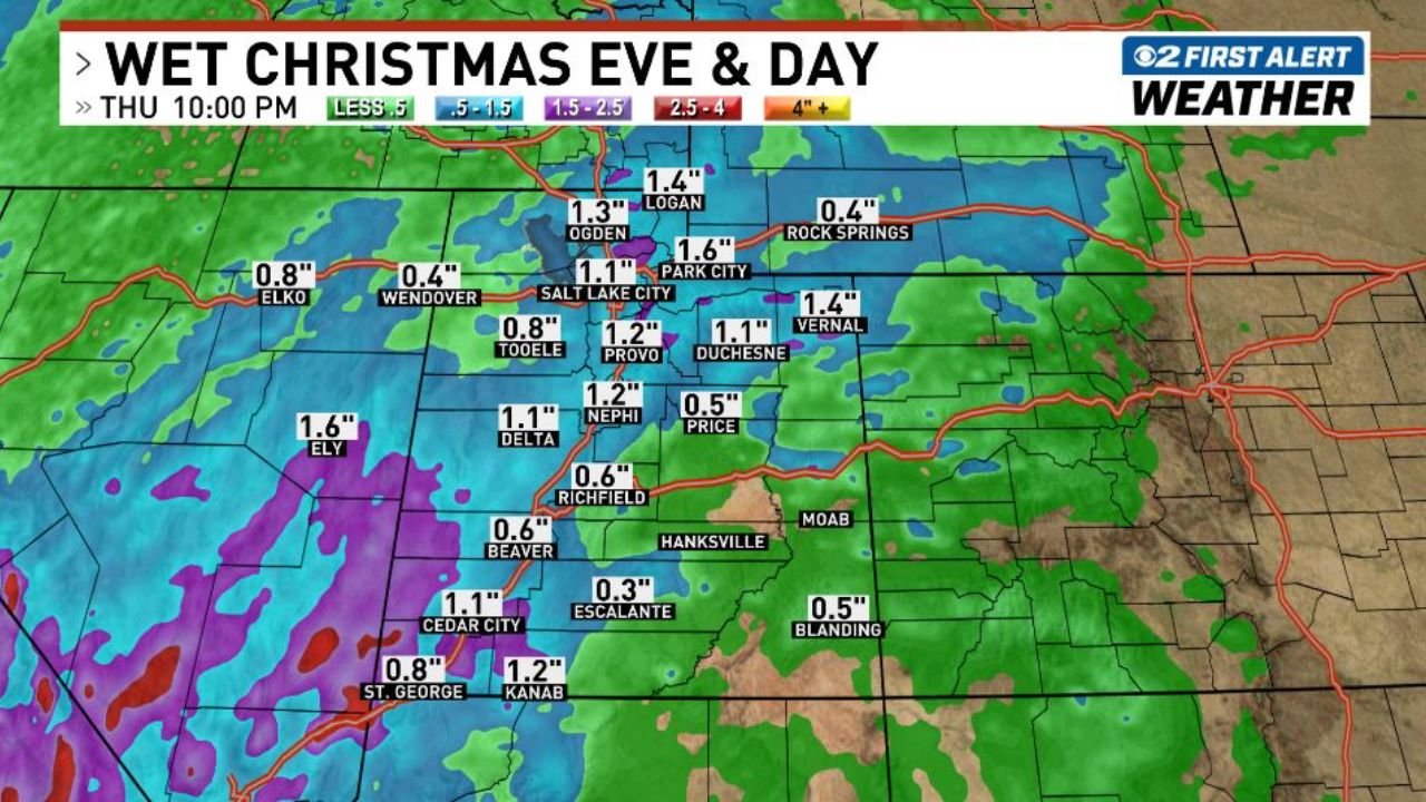
Model Guidance Highlights Increasing Precipitation Totals
New precipitation maps show widespread moisture statewide:
- Wasatch Front: ~1.0–1.6 inches
- Northern Utah valleys: ~0.4–1.4 inches
- Central Utah: 0.5–1.2 inches
- Southern Utah: 0.8–1.2 inches (particularly St. George, Kanab, Cedar City)
- High-elevation zones: higher totals likely, with heavy snow accumulations
Moisture transport is being enhanced by a strong subtropical plume, characteristic of a robust atmospheric river event.
Travel Impacts Likely in Higher Elevations
Although valley impacts will be relatively mild, mountain passes may see hazardous travel, particularly:
- Parleys Canyon (I-80)
- Provo Canyon (US-189)
- SR-14 near Cedar City
- Summit areas of SR-12, SR-24, and US-89
Heavy snow, reduced visibility, and slushy or icy road surfaces are possible during peak precipitation.
Looking Ahead
Forecasters note that model details are still being refined, particularly snow levels and timing of the coldest air. However, the overall signal remains strong:
Utah is headed for a wet, stormy Christmas holiday.
More updates will be issued as confidence increases.
For more weather updates and storm coverage, stay with ChicagoMusicGuide.com.