
Major Ice and Snow Threat to Sweep Across the South and Mid-Atlantic on Monday Night, Bringing Freezing Rain, Sleet, and Hazardous Travel
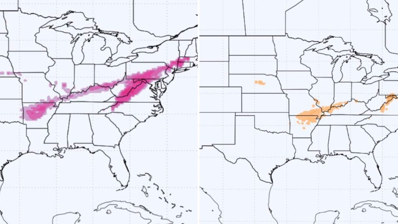
UNITED STATES – A Significant Ice and Winter Weather Event Expected Monday Night, A fast-moving winter system is forecast to push across the South and Mid-Atlantic Monday evening, bringing a mix of freezing rain, sleet, and light snow across several states that typically do not experience early-season winter hazards. Updated forecast models show a long corridor of pink and orange shading — representing ice and sleet probabilities — stretching from Arkansas and Tennessee through Kentucky, West Virginia, Virginia, and into parts of the Mid-Atlantic.
This setup indicates a potentially disruptive night of hazardous travel, low visibility, and rapidly worsening roadway conditions.
Freezing Rain Threat Spreads Through the South and Appalachians
The left-panel map shows widespread areas in pink, signifying a higher probability of freezing rain accumulation. This zone extends across:
- Northern Arkansas
- Western and Middle Tennessee
- Southern Kentucky
- West Virginia
- Western and Central Virginia
Freezing rain in these areas could lead to slick roads, dangerous bridges, and difficult nighttime travel, especially for regions unaccustomed to dealing with ice in December.
Sleet Risk Overlaps With Travel Corridors
The second map highlights sleet probabilities, shaded in orange. This risk zone intersects major roadways and mountain passes across:
- Kentucky
- Tennessee
- West Virginia
- Virginia
- Parts of the Ohio Valley
Sleet can create sudden transitions from wet pavement to frozen surface, increasing the likelihood of spin-outs and vehicle instability.
Snow Possible in Some Southern States
While the primary concern is freezing rain and sleet, forecast text notes that snow is possible in areas that ordinarily mow grass into December — a sign of how unusual this setup is for the region. Even minor snow accumulations combined with ice could intensify travel disruptions.
At this stage, forecasters expect mixed precipitation, not deep snow totals, but the timing — Monday evening into overnight — makes this a high-impact event.
Potential Impacts for Musicians, Performers, and Regional Events
With ice and sleet developing Monday night, artists planning to travel for weekday performances, rehearsals, or holiday shows across the South and Mid-Atlantic should anticipate significant delays. Impacts may include:
- Hazardous highways through Tennessee, Kentucky, and West Virginia
- Slower load-ins due to icy walkways and parking areas
- Potential last-minute event rescheduling
- Reduced attendance for evening shows
- Risks for touring crews crossing mountain regions
Musicians traveling long distances — especially through the Appalachian corridor — should prepare alternate routes or plan for earlier departure times.
A Rapidly Developing Event Requiring Close Monitoring
This winter system is notable not only for its wide geographic reach, but also because it targets areas where roads, drivers, and cities are not well-prepared for ice. Even light freezing rain can lead to downed limbs, power interruptions, and hazardous commutes.
Residents and performers in the path of the storm are urged to stay updated with local forecasts as conditions can deteriorate quickly after sunset Monday.
How is this ice and sleet threat affecting your travel or event plans this week? Share your experience with us at ChicagoMusicGuide.com — we’re following the storm closely and want to hear from our community.