
Major Multi-Region Storm to Impact the Upper Midwest, Great Lakes, East Coast, Oregon, and Northern California With Snow, High Winds, Thunderstorms, and Flooding
UNITED STATES — A large, multi-region storm system is preparing to sweep across major sections of the United States from Thursday through Friday, bringing everything from heavy snow and blizzard-like conditions in the Midwest to gusty thunderstorms in the East, while the West Coast braces for flooding rainfall from a powerful atmospheric river.
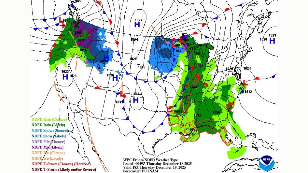
New surface maps and storm analyses show that the system will stretch across thousands of miles, affecting conditions from the Upper Midwest to eastern Canada, while simultaneously pushing a moisture-rich Pacific plume into Oregon and northern California. The combination makes this one of the broadest and most complex weather events of the month.
Snow and Blizzard-Like Conditions Across the Upper Midwest
A strong low-pressure center—forecast around 987 mb—will move across the Upper Midwest, producing widespread snow and corridors of locally intense snowfall. Some areas may experience near-whiteout conditions depending on wind strength and snow intensity.
Wind patterns surrounding the low are expected to enhance blowing snow, especially in open terrain. Travel impacts are likely along major interstate routes, including those connecting Minnesota, Wisconsin, Michigan, and southern Ontario.
High Winds, Gusty Showers, and Thunderstorms for the Great Lakes and Eastern U.S.
Farther south and east, the warm sector of the storm will generate bands of gusty showers and thunderstorms stretching from the Ohio Valley into the Mid-Atlantic and Southeast.
Forecast maps highlight:
- Widespread rain coverage from Mississippi to Virginia
- Pockets of potentially stronger thunderstorms within the warm, unstable air
- Wind gust zones drawn across the Great Lakes and central Appalachians
With strong frontal boundaries, these wind fields may cause localized power outages and hazardous driving conditions, particularly on Friday.
Atmospheric River to Hit Oregon and Northern California
At the same time, a major atmospheric river is set to strike the West Coast, bringing heavy to excessive rainfall to Oregon and northern California Thursday into Friday.
Key concerns include:
- Flooding danger on rivers already running high
- Rainfall totals capable of producing new or renewed flooding
- Mountain snow changing to rain, which may worsen runoff
The Pacific Northwest portion of the storm will also produce widespread mountain snowfall, but snow levels may climb temporarily as the warm moisture plume arrives.
Storm Timing Overview
Thursday:
- Atmospheric river reaches Oregon and northern California
- Snow expands across the Upper Midwest
- Rain bands develop through the Mississippi and Tennessee Valleys
Friday:
- Midwest storm center approaches eastern Canada
- Thunderstorms and gusty showers spread across the East Coast
- Flood risks rise in western Oregon and northern California
What This Means for Travel and Events
With ChicagoMusicGuide.com readers often planning tours, rehearsals, and travel, musicians and crews should anticipate:
- Flight delays at Midwest and East Coast airports
- Heavy rain-related cancellations on the West Coast
- Hazardous road conditions for van and bus travel across snow-covered regions
The system’s wide geographic reach makes it especially disruptive during a peak holiday season week.
Stay Updated
The storm will evolve quickly over the next 48 hours. Additional updates will be posted as new data arrives.
Stay safe and stay weather-aware — and keep following ChicagoMusicGuide.com for continued coverage.