
Major Winter Storm Targets Pennsylvania and Maryland With Ice Storm Warnings, Heavy Snow Forecast Across New York and Connecticut
PENNSYLVANIA — A significant winter storm is set to unfold across the Northeastern United States, beginning Friday evening and intensifying overnight, bringing dangerous ice accumulations, heavy snow, and widespread travel disruptions across multiple states, according to the latest forecast data and hazard outlooks.
Meteorologists warn that this system poses a high-impact ice threat in parts of western Pennsylvania and western Maryland, while heavy snow bands are expected to stretch eastward into New York, New Jersey, and Connecticut, with accumulations increasing rapidly by late Friday night.
Ice Storm Warnings Issued for Western Pennsylvania and Western Maryland
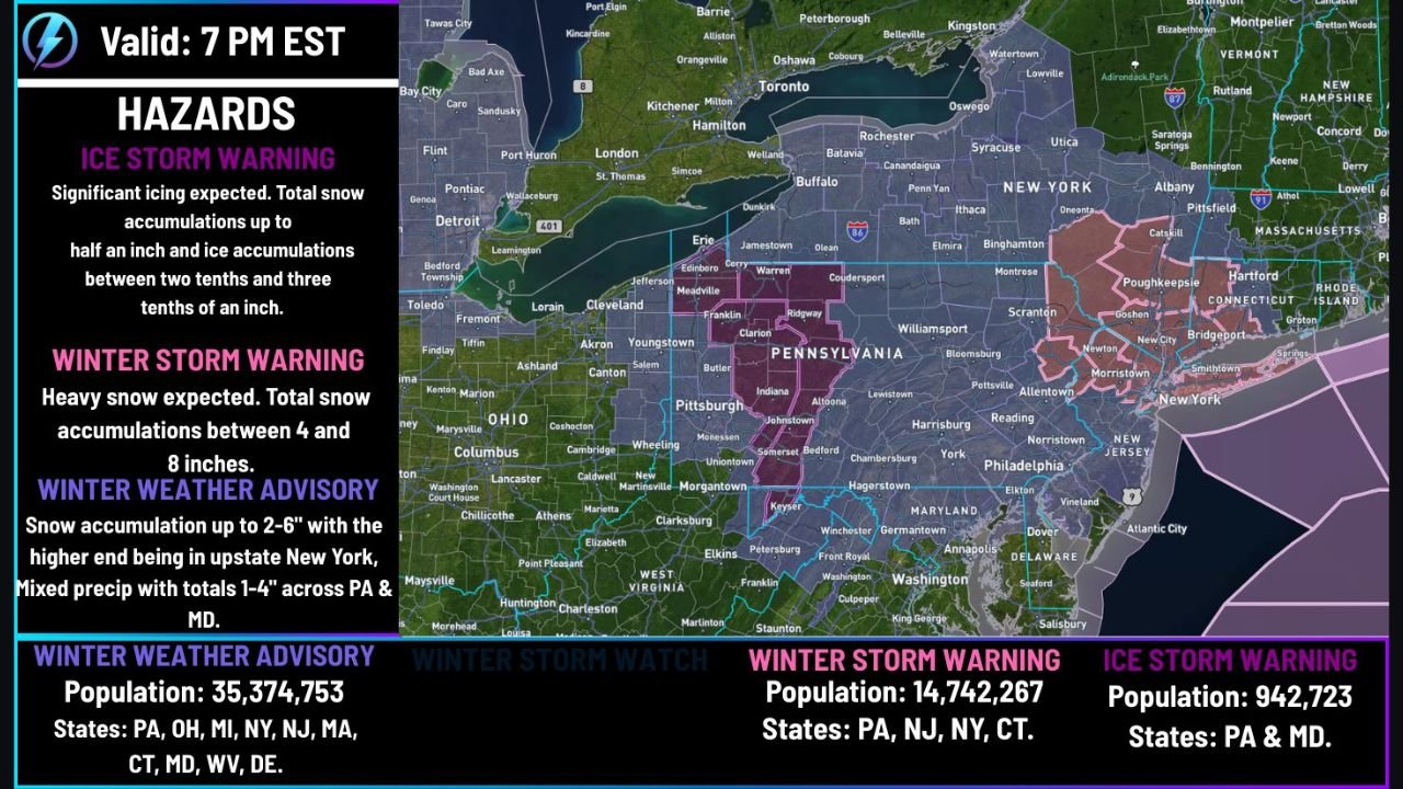
Forecasters have issued Ice Storm Warnings for portions of western Pennsylvania and western Maryland, where freezing rain totals of 0.20 to 0.30 inches are expected. In isolated areas, ice accretion could approach half an inch, enough to cause:
- Downed trees and power lines
- Widespread power outages
- Hazardous road conditions
- Structural stress on utility infrastructure
These areas are expected to experience significant icing before a transition to snow, making conditions particularly dangerous during the evening and overnight hours.
Winter Storm Warnings: Heavy Snow Expected Across the Interior Northeast
Farther north and east, Winter Storm Warnings are in effect for large portions of Pennsylvania, New Jersey, New York, and Connecticut, where heavy snowfall is forecast.
Current projections show:
- 4 to 8 inches of snow for much of central and eastern Pennsylvania
- Higher localized totals possible where snow remains dominant throughout the event
- Rapid snowfall rates during the peak overnight period
Snow is expected to accumulate quickly, especially in areas north of the primary ice zone, leading to difficult-to-impossible travel conditions.
Snowfall Outlook: New York and Connecticut Could See Higher Totals
In New York and Connecticut, snowfall amounts will vary based on elevation and proximity to the storm’s rain–snow transition zone.
Forecast guidance suggests:
- 2 to 6 inches of snow for many lower elevations
- Higher totals in upstate New York and interior Connecticut
- A narrow zone of uncertainty where mixing with sleet or freezing drizzle could reduce totals late in the storm
Meteorologists note that this transition zone remains one of the most challenging aspects of the forecast and could shift slightly as the system develops.
Winter Weather Advisories Cover a Broad Multi-State Area
Beyond warning areas, Winter Weather Advisories are in effect across a wide region that includes:
- Pennsylvania
- Ohio
- Michigan
- New York
- New Jersey
- Massachusetts
- Connecticut
- Maryland
- West Virginia
- Delaware
In these locations, residents can expect 2 to 6 inches of snow, with mixed precipitation totals of 1 to 4 inches in areas closer to the rain–ice boundary.
Timing and Impact: When Conditions Will Worsen
The storm is expected to:
- Begin impacting the region Friday evening
- Intensify overnight into early Saturday morning
- Produce the most hazardous conditions during late-night and early-morning hours
Travel is strongly discouraged during peak impacts, especially in areas under Ice Storm Warnings, where even light traffic can become dangerous within minutes.
Why This Storm Is Particularly Dangerous
This system combines significant icing, heavy snow, and a large population footprint, affecting tens of millions of people across the Northeast. Ice accumulations alone pose a serious risk, but when combined with snow and wind, impacts can escalate quickly.
Emergency officials urge residents to:
- Prepare for possible power outages
- Avoid unnecessary travel
- Monitor official weather updates closely
What Comes Next
Forecasters will continue refining snowfall and ice totals as the storm approaches, but confidence is high that this will be a major winter weather event with real impacts across multiple states.
Residents in affected areas should finalize preparations now and remain alert as conditions deteriorate.
If this storm affects your area or changes your weekend plans, we want to hear from you. Share your local conditions, photos, or travel experiences — and stay connected with ChicagoMusicGuide.com for continued weather updates and regional coverage.