
Maryland, Virginia, Pennsylvania Monitor Late-Week Storm Setup as Phasing Could Determine Snow Potential
UNITED STATES — Forecast models are beginning to show signs of a potential winter storm affecting parts of the Mid-Atlantic and Northeast later this week, but meteorologists caution that snowfall outcomes remain highly uncertain as the system is still several days away.
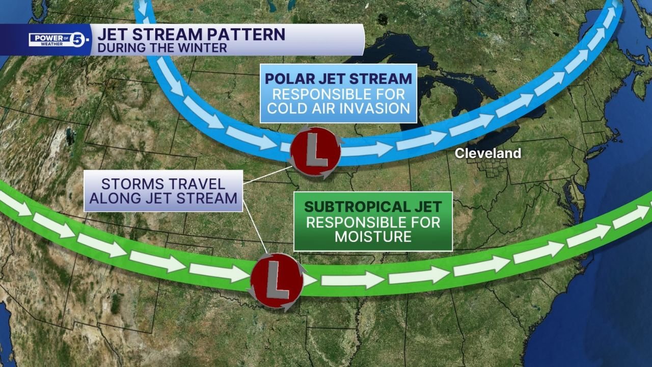
Current data suggests the possible “phasing” of two separate storm systems — a northern disturbance bringing colder air and a southern system rich in moisture. Whether these systems align in time and strength will ultimately decide how far inland snow reaches and whether any impacts become meaningful.
What “Phasing” Means for This Potential Storm
In winter forecasting, phasing refers to two jet-stream-driven systems merging into a single, stronger storm. When this occurs correctly, it can rapidly intensify precipitation and expand snowfall coverage.
Right now, models show:
- A northern system capable of pulling colder air southward
- A southern system carrying significant Gulf and Atlantic moisture
The challenge lies in timing. If the moisture arrives too late or the cold air departs too early, snow totals drop quickly or shift north and west.
Snow Probabilities Remain Modest for Major Cities
Ensemble data from the ECMWF — widely regarded as one of the most reliable global models — currently shows only moderate odds of at least 1 inch of snow across much of the I-95 corridor.
Key probability highlights include:
- Baltimore metro: roughly 30–40%
- Washington, D.C.: closer to 20%
- Philadelphia: near 40%
- Richmond and southern Virginia: closer to 10–20%
These numbers reflect uncertainty, not a guaranteed outcome. Importantly, they are based on dozens of different model simulations rather than a single deterministic forecast.
Why Early Snow Maps Can Be Misleading
Many widely shared snow maps rely on a single model run, which can exaggerate impacts several days in advance. Ensemble forecasting tells a more realistic story by showing a wide range of possible outcomes.
Some simulations depict accumulating snow, while others show mostly rain or minimal impacts. This spread indicates that forecast confidence is still low, and small shifts in storm track or temperature profiles could dramatically change results.
Meteorologists generally note that within three days of an event, forecast skill improves significantly — especially when determining rain versus snow.
What We Know with More Confidence
While valley and metro snowfall remains uncertain, higher-elevation areas across the central Appalachians have a much stronger signal for snow, potentially moderate depending on timing and intensity.
Additionally:
- Ground temperatures remain relatively warm
- Snow accumulation efficiency may be limited early on
- A slight inland shift would favor heavier snow north and west of major cities
What Happens Next
Over the next several days, forecasters will monitor:
- Whether the northern and southern systems align more closely
- How quickly cold air locks in
- The exact storm track along or offshore of the East Coast
A clearer picture should emerge 48–72 hours before the system arrives, at which point snowfall forecasts will become far more reliable.
Why This Matters for Travelers and Event Planning
Even modest snow can disrupt travel corridors in the Mid-Atlantic, particularly along I-95 and major rail routes. Residents and travelers should stay alert for updates, especially if plans involve late-week or weekend travel.
At this stage, the setup is worth watching — not panicking over.
Stay Connected
Weather patterns like this can evolve quickly. For ongoing updates, breakdowns of forecast confidence, and clear explanations without hype, keep following coverage on ChicagoMusicGuide.com and share your thoughts in the comments — are you expecting snow where you live, or just another near miss?