
Massachusetts, New Hampshire, Vermont, and Maine Expected to See Muted Pre-Christmas Warm-Up as Upper-Level Trough Keeps Significant Northeast Warmth in Check
NEW ENGLAND — Late-December Pattern Limits Big Warm-Up for the Far Northeast, While a large part of the United States is gearing up for a noticeable warm-up heading into Christmas, Massachusetts, New Hampshire, Vermont, and Maine are expected to miss out on any major or long-lasting “torch” pattern.
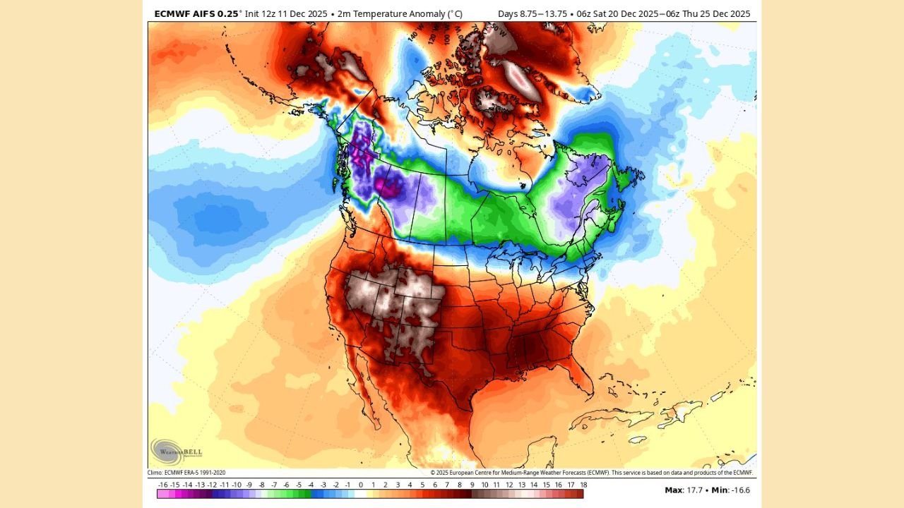
New forecast maps for the period around December 20–25 show a strong pocket of colder air and lower atmospheric heights over southeastern Canada and the far Northeast, keeping the region from experiencing the same intensity of warmth spreading across the central and southern states.
Upper-Level Trough Over Canada Blocks Any Major Heat Surge
Forecast upper-air charts highlight a broad ridge of higher pressure and warmth over the western and central United States, but over New England and nearby Canada, a pronounced trough digs southward.
This setup means:
- The warmest air stays focused from the Rockies to the Midwest and Mid-Atlantic
- Cooler, more unsettled air lingers over northern New England and eastern Canada
- Any warm spells in Massachusetts, New Hampshire, Vermont, and Maine are likely to be short-lived rather than a long, extended stretch
In simple terms, the atmosphere is arranged so that true “blowtorch” warmth is very unlikely to lock in over New England.
Temperature Maps Show Countrywide Warmth, With Northeast Standing Out as an Exception
The accompanying temperature anomaly map for the same late-December period paints a clear picture:
- Much of the central and southern U.S. shows deep shades of red, signaling well above normal temperatures
- The Pacific Northwest and parts of Canada hold onto colder-than-normal readings
- Across New England and the far Northeast, colors are muted greens and light blues, indicating near-normal or only slightly above/below normal temperatures
For residents in Boston, Concord, Burlington, and Bangor, that means the region may see a few milder days, but nothing like the strong warmth being advertised farther south and west.
Not a Classic Snow Pattern, but Also Not a “Warmth Lock” for New England
This late-December pattern is somewhat mixed for snow lovers:
- The trough over southeastern Canada can keep colder air close by
- At the same time, storm tracks may be less favorable for big, widespread snow events
- The setup is not the classic “Southeast ridge of death” that floods New England with warm, rainy air for days on end
Instead, New England looks to be caught in between:
cooler than the rest of the country, but not locked into a deep freeze or a nonstop snowstorm pattern.
What Residents in Massachusetts, New Hampshire, Vermont, and Maine Should Expect
Heading into the days before Christmas, people across New England should be prepared for:
- Temperature swings, with some milder days mixed with cooler intrusions
- Limited chances for major, long-duration warmth, despite national headlines about a big warm-up
- A pattern that still allows for chilly nights and seasonable cold, especially in the interior and higher elevations
Travelers returning home for the holidays may find conditions in New England noticeably cooler compared to the Midwest, South, or Mid-Atlantic, where the warm surge will be much stronger.
Stay Tuned With ChicagoMusicGuide.com
ChicagoMusicGuide.com will continue watching how this pattern evolves as Christmas approaches, keeping an eye on any late-developing systems that could bring New England a burst of snow or a brief mild spell.
For more weather updates, tour forecasts, and event coverage that matter to music fans and readers across the country, keep checking back with ChicagoMusicGuide.com.