
Massachusetts Snow Forecast Shows Accumulating Snow Bands With Heavier Totals South of Boston Through Saturday Morning
Massachusetts — A developing winter weather system is spreading across the state late Friday night into Saturday morning, bringing accumulating snow with sharply varying totals depending on location, as dry air continues to push back against the system from the north. Forecasters say the evolving setup will lead to narrow snow bands, creating notable differences in snowfall amounts across short distances.
While confidence is high that snow will occur statewide, meteorologists caution that exact placement of heavier bands remains uncertain, particularly across eastern and southeastern portions of Massachusetts where totals could rise quickly overnight.
How the Snow System Is Developing Across Massachusetts
Forecast maps show snow expanding from west to east overnight, with lighter accumulations across northern Massachusetts and more persistent snowfall developing farther south. Areas closer to the New Hampshire border are expected to remain on the lower end of totals as drier air limits snow growth.
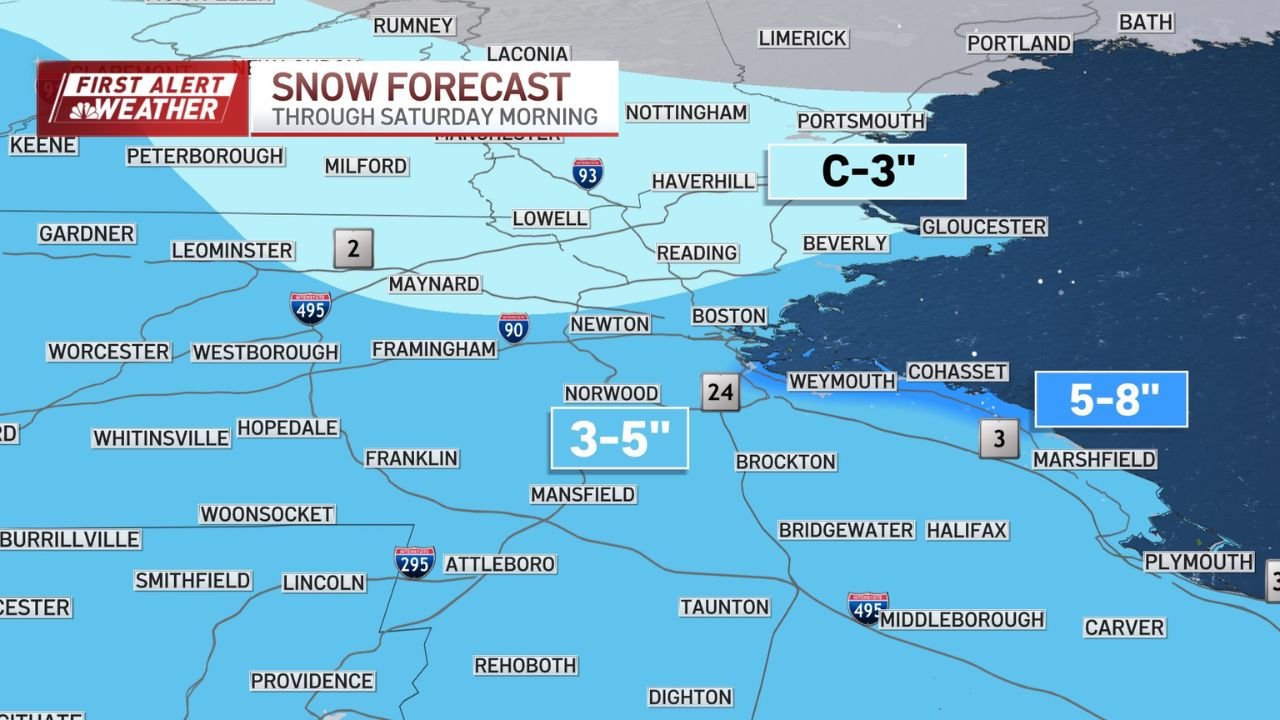
Across central Massachusetts, including Worcester County, snow is expected to become steadier late tonight, with totals generally falling into the 3 to 5 inch range by Saturday morning. The most impactful snow, however, is forecast farther south.
Meteorologists note that the system is battling dry air aloft, which may temporarily weaken snowfall rates before stronger forcing arrives later in the night.
Heaviest Snow Focused South of Boston and the South Coast
According to the latest snowfall maps, southern Massachusetts and coastal areas south of Boston are most likely to see higher snow totals, particularly where mesoscale banding becomes established.
Communities across parts of Plymouth County and the South Coast could see snowfall totals reach 5 to 8 inches, with localized higher amounts possible if heavier bands persist. These areas remain the most sensitive to small shifts in storm dynamics, which could quickly raise or lower final totals.
Forecasters stress that residents in these zones should be prepared for rapid changes in snowfall intensity overnight, especially during the pre-dawn hours.
Lower Totals Expected in Northern Massachusetts
Northern sections of the state, including areas closer to the New Hampshire border, are forecast to see lighter snowfall, generally ranging from coating to around 3 inches. Dry air intrusion is expected to limit snow production in these regions, keeping totals lower than areas farther south.
While travel impacts may be less severe in northern Massachusetts, slick spots are still possible early Saturday, particularly on untreated roads and elevated surfaces.
Travel Impacts and Timing Concerns
Snow is expected to continue through early Saturday morning, with conditions gradually improving later in the day as the system moves offshore. The most impactful travel window appears to be late tonight through early Saturday, when snowfall rates may briefly increase within heavier bands.
Drivers are urged to use caution, particularly in southern and southeastern Massachusetts where snow-covered roads and reduced visibility could develop quickly.
As winter weather patterns continue to shift across the region, stay connected with ChicagoMusicGuide.com for continued weather updates, regional forecasts, and timely alerts that help you plan safely through changing conditions.