
Michigan and Wisconsin Brace for Potential 30 to 40 Inch Blizzard Totals as Marquette and Sault Ste. Marie Face 36 to 42 Inches While Chicago, Illinois Sees Minimal Snow
MARQUETTE, MICHIGAN — A powerful blizzard setup is taking aim at the Upper Great Lakes, with forecast models indicating extreme snowfall totals across parts of Michigan and Wisconsin through Tuesday night — while Chicago, Illinois remains largely on the lower end of the accumulation spectrum.
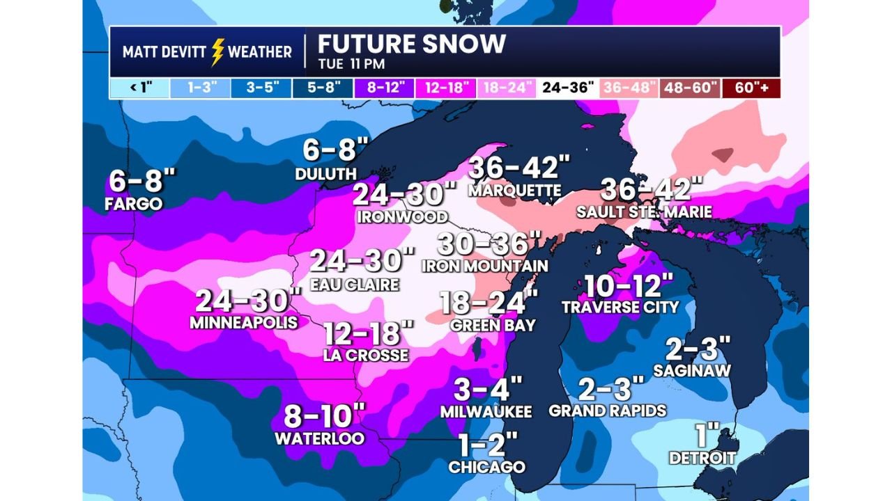
The latest American model snow output paints a dramatic contrast across the region, with some communities facing more than 3 feet of snow.
Upper Peninsula of Michigan in the Bullseye
The heaviest snowfall axis centers on Michigan’s Upper Peninsula, particularly around:
- Marquette, Michigan: 36–42 inches
- Sault Ste. Marie, Michigan: 36–42 inches
- Iron Mountain, Michigan: 30–36 inches
Localized amounts could exceed 40 inches where persistent lake enhancement develops.
These totals would easily meet blizzard criteria when combined with strong winds, producing whiteout conditions and significant travel disruptions.
Northern Wisconsin and Minnesota Also Facing Major Totals
The storm’s western flank stretches into northern Wisconsin and eastern Minnesota, where widespread heavy snow is projected:
- Ironwood, Michigan: 24–30 inches
- Eau Claire, Wisconsin: 24–30 inches
- Minneapolis, Minnesota: 24–30 inches
- Green Bay, Wisconsin: 18–24 inches
- La Crosse, Wisconsin: 12–18 inches
In portions of northern Wisconsin and the western Upper Peninsula, snowfall over 30 inches is possible where banding sets up.
Moderate Totals for Northern Lower Michigan
Northern Lower Michigan is also expected to see impactful snowfall, though not at the extreme levels of the Upper Peninsula:
- Traverse City, Michigan: 10–12 inches
- Saginaw, Michigan: 2–3 inches
- Grand Rapids, Michigan: 2–3 inches
Snowfall quickly tapers south and east of the heaviest band.
Sharp Drop-Off Toward Illinois and Southeast Michigan
While areas to the north brace for feet of snow, Chicago, Illinois appears largely spared from the brunt of the storm.
- Chicago, Illinois: 1–2 inches
- Milwaukee, Wisconsin: 3–4 inches
- Detroit, Michigan: Around 1 inch
The gradient in snowfall is steep, with heavy accumulation focused north of Lake Michigan and Lake Superior.
Blizzard Conditions Likely in the Upper Great Lakes
With snowfall totals exceeding 30 inches in several zones and winds expected to increase, blizzard conditions are likely across:
- Marquette, Michigan
- Sault Ste. Marie, Michigan
- Iron Mountain, Michigan
Heavy snow combined with strong winds could create:
- Near-zero visibility
- Drifting snow
- Hazardous to impossible travel
- Potential power disruptions
Why the Totals Are So Extreme
The setup favors prolonged deformation banding and lake-enhanced snowfall, particularly near Lake Superior. Cold air wrapping into the system will help maintain high snow ratios, increasing accumulation efficiency.
As the system stalls or slows over the region, snowfall could continue in waves through Tuesday.
Chicago Impact Remains Limited
For Chicago and much of northern Illinois, snowfall remains on the fringe of the main storm track. Light accumulations of 1–2 inches are possible, with slightly higher totals north of the city.
Travel impacts in Illinois appear minimal compared to conditions expected across Michigan and northern Wisconsin.
Final Outlook
This storm highlights the sharp divide across the Great Lakes region:
- Extreme, potentially historic snowfall in Michigan’s Upper Peninsula
- Significant but lower totals in Wisconsin and Minnesota
- Minor accumulations for Chicago, Illinois and Detroit, Michigan
Residents in Marquette, Sault Ste. Marie and surrounding communities should prepare for prolonged heavy snow and dangerous travel conditions.
Stay with ChicagoMusicGuide.com for continued updates as snowfall forecasts are refined and warnings are issued.