
Midwest Snow Hype, Florida Flurries, and Multiple Travel Alerts: What’s Real vs. What’s Going Viral This Week
UNITED STATES – A messy stretch of January weather is setting up across several regions, with lake-effect snow targeting Michigan and Indiana, dense fog in Oregon and Washington, burn bans spreading in Arkansas, and ice concerns in the Mid-Atlantic—all while viral “5-feet of snow” posts circulate online using long-range model graphics that aren’t actual forecasts.
What’s Getting Attention Right Now—and Why It Matters
A lot of the loudest weather chatter this week is being driven by model runs far into the future, including social posts that claim a “bonkers snowstorm” with extreme totals across the Midwest. The key detail: some of these maps are shown well beyond 240 hours, where accuracy drops fast and dramatic swings are common.
That doesn’t mean nothing is happening—there are very real, near-term hazards on the board. It just means it’s important to separate near-term alerts and official briefings from viral screenshots designed to shock-scroll.
Michigan and Indiana: Lake-Effect Snow Bands Could Reload Multiple Times
Forecast guidance highlights plenty of snow potential over the next week in parts of Michigan and Indiana, especially in the typical lake-effect belts. The snow signal is not evenly spread—these events often come in narrow bands, meaning one town can get buried while another is just dealing with flurries.
What the snow maps suggest:
- Heaviest totals favor lake-effect corridors, including areas near Lake Michigan and Lake Superior where bands can sit for hours.
- The setup is being described as snow bands developing tomorrow/Thursday, with the possibility of another round over the weekend.
- If a band locks in, localized totals can climb quickly, and travel conditions can change mile-to-mile.
For anyone traveling for shows, rehearsals, or weekend plans: lake-effect is notorious for rapid visibility drops, sudden slick roads, and unexpected delays even when broader regional forecasts look “fine.”
Mid-Atlantic: Thursday Morning Could Turn Icy Fast After Rain
An advisory-style graphic for the Philadelphia/Mount Holly region highlights a classic winter hazard: rain transitioning to a brief snow or rain/snow mix, followed by rapidly falling temperatures early Thursday.
The risk isn’t huge snow accumulation—it’s what happens after:
- Precipitation is expected to wrap up around the early-morning commute window, but
- Temperatures dropping into the 20s can flash-freeze wet and slushy surfaces,
- Creating slick sidewalks, bridges, and untreated roads right when people are heading out.
Even “minor snow” setups like this can produce the kind of icy commute that causes spin-outs, delayed transit, and crowded emergency rooms. If you’re in this zone, it’s a “slow down and give yourself time” morning.
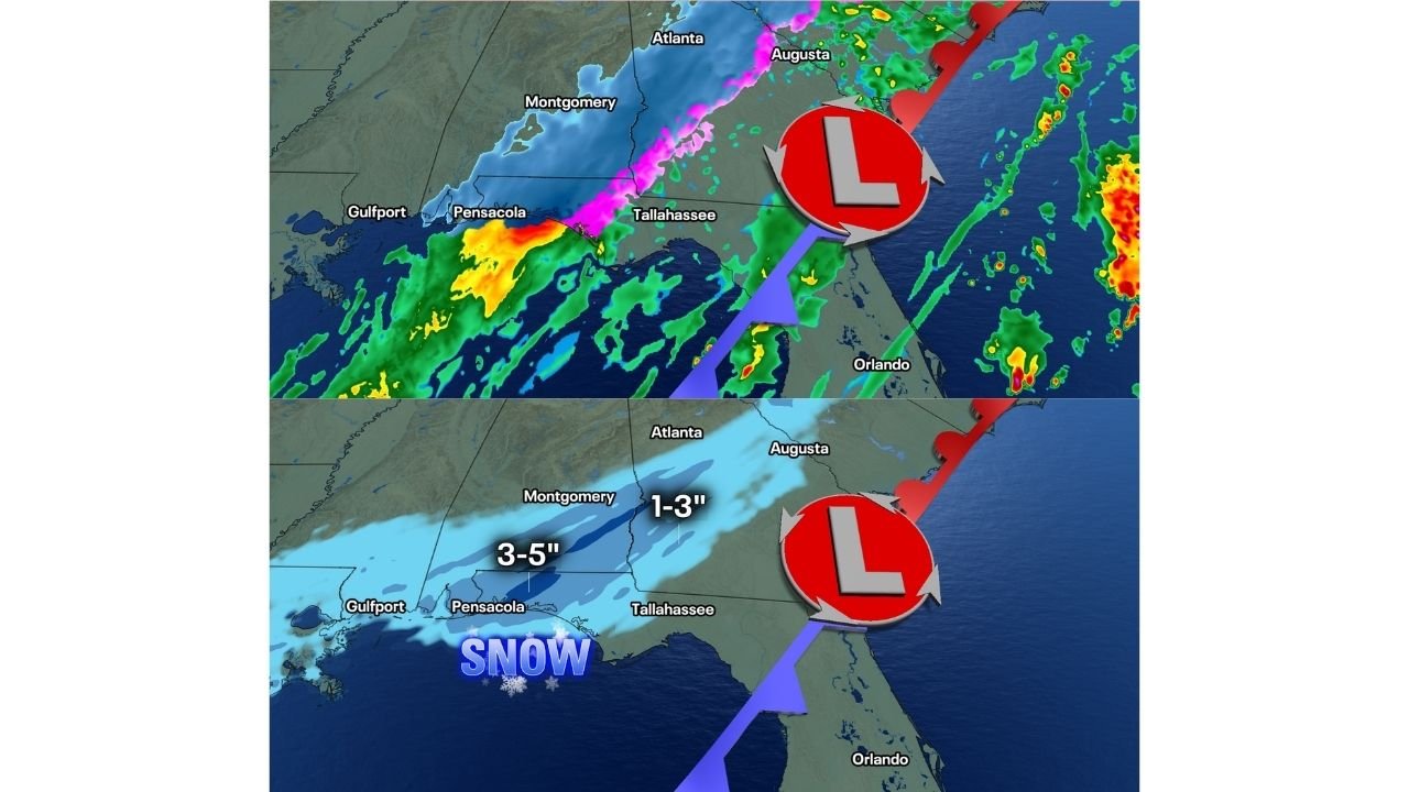
Florida Panhandle, South Georgia, and Southeast Alabama: A Real Snow Signal Is Being Watched
A separate set of graphics shows a growing conversation around snow potential along the I-10 corridor in the Florida Panhandle, with some projections also extending into southern Georgia and southeast Alabama.
The maps shown indicate:
- A corridor where several inches could be possible in parts of the Panhandle, and
- A lighter stripe farther inland into GA/AL in the same general timeframe.
This is the kind of setup that can cause outsized disruption because many areas here have limited winter road treatment resources. Even if totals end up lower, a narrow band of heavier snow or a wintry mix can still create serious travel issues.
Oregon and Washington: Dense Fog With Very Low Visibility for the Commute
The National Weather Service Portland graphic highlights a dense fog window from midnight through noon Wednesday (1/14) affecting:
- Willamette Valley
- SW Washington Lowlands
- Lower Columbia River
- North Oregon Coast Range Lowlands
The headline detail: visibility less than 1/4 mile is possible. That’s the kind of fog that turns normal drives into white-knuckle commutes, especially on bridges, river valleys, and lowlands where fog pools.
If you’re heading out early:
- Use low beams (not high beams, which can reflect back),
- Increase following distance,
- Expect sudden visibility drops even if conditions look clear a few minutes earlier.
Arkansas: Burn Bans Expanding as Wildfire Risk Stays Elevated
On the opposite end of the hazard spectrum, Arkansas is dealing with dry conditions and expanding burn bans. A statewide graphic notes moderate wildfire danger, while burn bans are being issued for additional counties with the expectation the list could grow if meaningful rain doesn’t arrive.
If you’re anywhere near burn-ban counties:
- Avoid open burning and unnecessary sparks,
- Don’t toss cigarettes,
- Keep vehicles off dry grass,
- Take towing/dragging chains seriously—road sparks are a real ignition source.
Winter fire risk can catch people off guard, but dry stretches can make grass and brush ignite fast even in January.
So…Is the “5 Feet of Snow” Midwest Map Real? Here’s the Honest Answer
Some of the viral snow maps circulating are tied to long-range model runs that are not forecasts and can exaggerate totals dramatically. When posts cherry-pick a single extreme run, it can look like a guaranteed event when it’s really just one scenario.
What’s real and actionable right now:
- Lake-effect snow risk in Michigan/Indiana in the near term,
- Fog affecting Oregon/Washington travel early Wednesday,
- Icy commute potential in the Mid-Atlantic Thursday morning,
- Fire danger and burn bans expanding in Arkansas,
- A monitored snow signal for the Florida Panhandle/GA/AL timeframe shown on the graphics.
Are you seeing delays, slick roads, or sudden visibility drops where you live—and do you think the viral “mega-snowstorm” posts are making things worse? Share what you’re noticing, and follow along for more weather updates on ChicagoMusicGuide.com.