Midwest Winter Storm Brings Blizzard Warnings, Heavy Snow, and Dangerous Travel Conditions Across Minnesota, Wisconsin, and Michigan
MINNESOTA — A major winter storm is sweeping across the Upper Midwest, bringing blizzard warnings, heavy snowfall, powerful wind gusts, and potentially life-threatening travel conditions from Sunday through early Monday morning, according to the latest regional forecasts and National Weather Service data.
Blizzard Warnings and Winter Storm Alerts Expand Across the Region
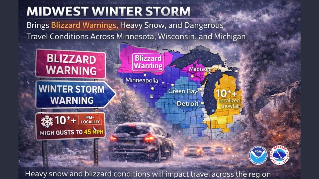
The most severe impacts are unfolding across eastern Minnesota and western Wisconsin, where Winter Storm Warnings and Blizzard Warnings remain in effect. Forecast maps indicate snowfall totals of 7–10 inches, with localized amounts exceeding 10 inches possible in narrow bands stretching from the Twin Cities metro into western Wisconsin, including areas near Eau Claire and New Richmond.
In central and southern Minnesota, blizzard conditions are expected despite somewhat lower snowfall totals. Meteorologists warn that strong northwest winds gusting between 40 and 55 mph will significantly reduce visibility, creating whiteout conditions even after snowfall tapers off.
Strong Winds Create Whiteout Conditions and Dangerous Travel
Wind gust forecasts show sustained high winds persisting well into Monday morning, especially across Minnesota, Wisconsin, and parts of northern Iowa. These winds will cause blowing and drifting snow, making roads impassable in rural areas and rapidly deteriorating conditions on major highways.
Transportation officials strongly advise motorists to avoid non-essential travel, noting that stranded vehicles could face prolonged exposure due to limited visibility and hazardous road access during peak storm conditions.
Upper Great Lakes Face Blizzard Conditions and Tree Damage Risks
Farther east, the storm is intensifying across the Upper Great Lakes, including Michigan’s Upper Peninsula. Blizzard warnings are posted near Marquette, Houghton, and Rhinelander, where heavy snow combined with high winds may lead to power outages and tree damage.
In northern Michigan, forecasters are particularly concerned about freezing rain accumulation of 0.25 to 0.50 inches on trees and power lines, followed by strong winds and additional snowfall. This combination significantly raises the risk of downed trees and extended power outages, especially in rural communities.
Why This Storm Is Especially Dangerous
Meteorologists describe this system as a high-impact, non-tropical storm with unusually strong wind potential. Advanced ensemble modeling suggests the possibility of wind gusts approaching hurricane force in localized areas across the Great Lakes region, including near Buffalo, New York, and along elevated terrain in the Appalachians later in the storm’s evolution.
The prolonged duration of snow, combined with intense winds and rapidly dropping temperatures, creates a perfect setup for life-threatening exposure risks for anyone stranded outdoors or on the roads.
What Residents Should Do Now
Emergency officials urge residents across Minnesota, Wisconsin, Michigan, and neighboring states to take immediate precautions:
- Delay or cancel travel plans until conditions improve
- Prepare emergency kits with blankets, food, water, and phone chargers
- Monitor local weather alerts and road conditions frequently
- Check on vulnerable neighbors, especially the elderly or those without reliable heating
Air travelers are also encouraged to check flight statuses, as delays and cancellations are likely at regional airports due to wind and snow impacts.
As the storm continues to evolve overnight, additional updates and advisories are expected across the Midwest and Great Lakes.
For continued coverage of severe weather updates, regional alerts, and community impacts, stay connected with ChicagoMusicGuide.com for timely information that keeps you informed and prepared.