
Minnesota, Wisconsin, Michigan and Northern Illinois Face Potential 12–30+ Inch Blizzard Threat as Multiple Models Flash Extreme Snow Signals Across Upper Midwest and Great Lakes
MINNEAPOLIS, MINNESOTA — Forecast models are lighting up with an unusually intense snow signal for the Upper Midwest and Great Lakes, with multiple ensemble systems pointing toward a potentially high-impact winter storm — and possibly a powerful blizzard — later this week.
The setup unfolds in two phases: one storm moving through over the next 48 hours, followed by a second, potentially stronger system that could bring extreme snowfall totals to parts of Minnesota, Wisconsin, Michigan, and northern Illinois.
First Storm: Widespread Accumulating Snow
The initial system is expected to spread accumulating snow across:
- Minnesota
- Wisconsin
- Northern Iowa
- Michigan
- Possibly into northern Illinois
While impactful, this first wave appears more moderate compared to what may follow.
Second System: Blizzard Potential Increasing
It’s the late-week storm that has forecasters’ attention.
Ensemble guidance from:
- ECMWF (EPS)
- Euro AI Ensembles
- GEFS
- National Blend of Models (NBM)
all show a strong, consistent signal for heavy snowfall centered over the Upper Midwest and the Great Lakes region.
When multiple global ensemble systems align with similar high-end totals — especially including the NBM, which is typically conservative — it signals an elevated risk of a significant winter event.
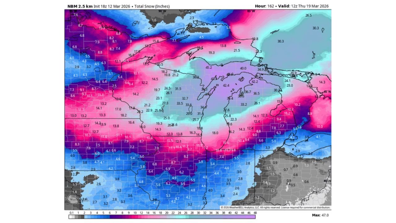
Snowfall Totals: Eye-Catching Projections
Model output suggests widespread double-digit snowfall totals across:
- Minneapolis–St. Paul
- Duluth
- Green Bay
- Milwaukee
- Madison
- Grand Rapids
- Detroit
- Northern portions of Chicago’s metro area
In some scenarios, snowfall amounts exceed:
- 15–20 inches across central Wisconsin
- 20+ inches in parts of northern Michigan
- 10–15 inches across southern Minnesota and northern Illinois
- Higher localized totals where banding develops
The National Blend of Models indicates particularly high-end potential in portions of Michigan, with some areas exceeding two feet in ensemble means.
Why This Setup Is Concerning
Several atmospheric ingredients appear to be aligning:
- Strong low-pressure development tracking near or south of the Great Lakes
- Deep moisture transport into the cold sector
- Prolonged deformation banding
- Tight pressure gradients capable of producing strong winds
If the storm deepens as projected, blizzard conditions could develop, especially in open areas of Minnesota, Wisconsin, and Michigan, where blowing and drifting snow may reduce visibility significantly.
Chicago’s Position: On the Southern Edge
For Chicago and northern Illinois, the exact storm track will be critical.
A slightly northward shift would bring heavier totals into the city and surrounding suburbs. A more southern track would limit Chicago’s totals but still produce impactful snowfall.
At this range, residents across the metro should prepare for the possibility of significant travel disruptions later this week.
A Rarely Aligned Signal
What makes this event stand out is the agreement across multiple ensemble systems. It is uncommon to see:
- EPS
- Euro AI
- GEFS
- NBM
all indicating widespread high-end snowfall in the same corridor.
While details will continue to evolve, the Upper Midwest and Great Lakes appear increasingly likely to face a major winter storm threat.
For continued updates on this developing snow signal and potential blizzard across Minnesota, Wisconsin, Michigan, and Illinois, stay with ChicagoMusicGuide.com.