
Mississippi, Louisiana, Alabama, and Texas Face Moderate Flash Flood Risk as Heavy Rainfall Targets Lower Mississippi Valley
MISSISSIPPI, LOUISIANA, ALABAMA, and TEXAS — A dangerous heavy rainfall setup is unfolding today across parts of the Lower Mississippi Valley and Southeast, with forecasters warning that numerous flash floods are likely, especially in southern Mississippi, according to the latest Weather Prediction Center (WPC) Day 1 Excessive Rainfall Outlook.
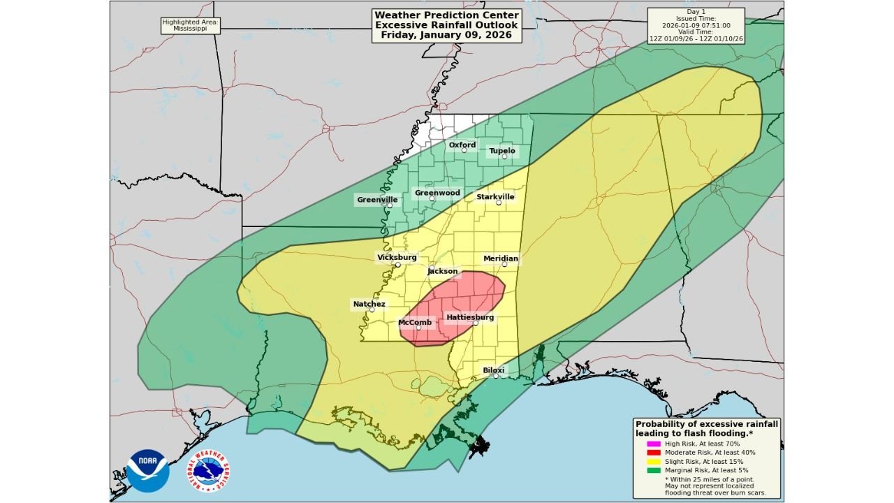
A Moderate Risk (Level 3 of 4) has been issued, signaling a high confidence scenario for flooding impacts. Surrounding areas are under Slight and Marginal Risk zones, meaning flooding could still occur outside the highest-risk region as storms move through.
Moderate Risk Zone Centers on Southern Mississippi
The most serious threat is focused on southern Mississippi, including areas near Hattiesburg, McComb, Jackson, and Meridian, where repeated rounds of heavy rain are expected.
Forecast guidance shows:
- Rainfall totals of 3 to 6 inches
- Rain rates of 2 to 3 inches per hour
- Multiple storm rounds tracking over the same areas
These conditions significantly increase the risk of rapid flash flooding, particularly in low-lying areas, urban corridors, and regions with saturated ground.
Texas and Louisiana Included in the Flood Threat
The data clearly shows that eastern Texas and much of Louisiana are also part of the excessive rainfall outlook, especially in the Marginal to Slight Risk zones.
Areas of concern include:
- Eastern Texas, where storms may repeatedly move over the same locations
- Central and southern Louisiana, including areas near Alexandria, Baton Rouge, and Lafayette
While flooding may be more localized in these regions, isolated flash floods are still possible, especially where drainage is poor or rain bands stall.
Alabama Also at Risk as Storms Shift East
As the system progresses eastward, southern and central Alabama fall under a Slight Risk, meaning flash flooding remains a concern.
Cities and communities near:
- Mobile
- Montgomery
- Western and central Alabama counties
could see periods of intense rainfall, particularly later in the day and into the evening.
Why the Flood Risk Is Elevated Today
Meteorologists highlight several key factors contributing to today’s threat:
- A slow-moving frontal boundary
- Deep tropical moisture feeding into storms
- Repeated storm development over the same areas
- Strong atmospheric lift supporting heavy rain production
Even areas that avoid the worst storms could experience brief but intense downpours, enough to overwhelm drainage systems.
What Residents Should Do
People across Mississippi, Louisiana, Alabama, and eastern Texas are urged to take this situation seriously:
- Avoid driving through flooded roads
- Be prepared for rapid water rises
- Monitor local weather alerts throughout the day
- Have multiple ways to receive warnings, especially overnight
Flash flooding can develop quickly and with little warning, even outside the highest-risk zone.
Final Outlook
The Moderate Risk designation means flooding is not just possible — it is likely in parts of the Lower Mississippi Valley today. Conditions will evolve rapidly, and impacts may continue into the evening and overnight hours.
Stay weather-aware, follow local advisories, and avoid unnecessary travel during heavy rain periods.
For continued weather updates, regional impact breakdowns, and real-time alerts, stay connected with ChicagoMusicGuide.com.