
Missouri, Illinois, and Kentucky on Alert as Storms Near Cape Girardeau Intensify with Hail and Spin-Up Risk
MISSOURI – A fresh round of strong thunderstorms is firing up this evening in southeast Missouri, bringing the threat of hail, strong winds, and possible brief tornado spin-ups as they move east into southern Illinois and western Kentucky.
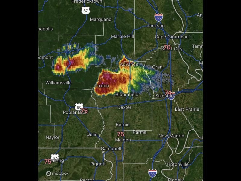
Storms Building Fast Near Cape Girardeau
As of 4:30 p.m., radar imagery shows multiple storms forming between Puxico, Advance, and Bloomfield, stretching toward Cape Girardeau and tracking slowly east. Meteorologists say the storms are showing signs of strong rotation and intense cores, suggesting that some could become organized supercells if they continue to strengthen.
Communities in southeast Missouri are currently seeing frequent lightning, heavy downpours, and pockets of hail, especially along Highway 60 near Poplar Bluff and Dexter. The system’s slow eastward movement means parts of southern Illinois and western Kentucky will soon be under the gun as well.
Severe Threat Expanding Toward Illinois and Kentucky
The storms are expected to drift across the Mississippi River this evening, entering southern Illinois and western Kentucky, including areas near Paducah and Cairo.
Forecasters warn that hail up to one inch in diameter, gusty winds over 50 mph, and isolated tornado spin-ups will be possible — particularly if the storms maintain their current structure and tap into strong surface moisture.
Meteorologists tracking radar signatures near Bloomfield and Puxico noted the presence of tight velocity couplets, which can sometimes indicate rotation inside stronger cells.
Residents Urged to Stay Weather-Aware
Officials and local weather stations across the region are reminding residents not to let their guard down, as evening storms in the fall can develop quickly and intensify after dark.
People living in low-lying or rural areas are urged to monitor alerts, have multiple ways to receive warnings, and stay prepared to seek shelter if a warning is issued.
Drivers along I-55 and Route 60 should also be cautious of sudden downpours, reduced visibility, and potential hail bursts.
Online Reactions and Local Concerns
Social media users across southeast Missouri are already sharing storm photos and radar screenshots. One local resident from Bloomfield wrote on Facebook:
“The sky’s gone that weird green again — here we go!”
Another user from Cape Girardeau commented,
“Just heard the first hail hitting my windows. Hoping it doesn’t get worse.”
Meanwhile, storm chasers on X (formerly Twitter) have begun posting live radar loops showing strong storm signatures moving steadily toward the Illinois border, noting that “any cell that organizes could spin briefly.”
Meteorologists Watching for Further Development
Weather experts say that while these storms are isolated for now, any that merge or strengthen could evolve into a larger complex, heightening the risk for damaging winds across the tri-state area through the evening.
If storms organize further, the National Weather Service may issue severe thunderstorm warnings or brief tornado advisories for affected counties. The potential for hail remains the top concern early, with gusty winds and short-lived rotations possible through sunset.
What Do You Think?
Do you think tonight’s storms will intensify into something more dangerous, or will the front lose energy before hitting Illinois and Kentucky? Share your thoughts and stay tuned for updates at chicagomusicguide.com.