Monday Severe Weather Threat Shifts South of Chicago as Southern Two-Thirds of Illinois Face Large Tornadoes and Hail While Damaging Winds Target the Peoria Line
PEORIA, IL — The forecast is sharpening and the storm track is shifting. Evening model runs valid for Monday, April 27, 2026 are now showing a clear and consistent trend — the most serious severe weather threat for Illinois is edging south and southwest of the Chicago metro area, concentrating the large tornado and significant hail risk across the southern two-thirds of Illinois while the Chicago area itself transitions to a primarily damaging wind threat.
This is not a reprieve for anyone in Illinois. The threat has not weakened — it has focused. And where it has focused, the atmosphere is primed for a dangerous afternoon and evening.
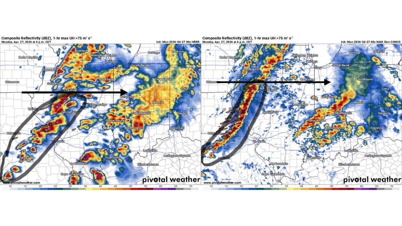
What Two High-Resolution Models Are Agreeing On
Two of the highest-detail short-range models available — both initialized Monday morning — are in strong agreement on the storm structure and positioning for Monday at 6:00 PM CDT. That level of model agreement at this range is a significant forecasting signal and increases confidence in the overall storm track.
Both models show a well-organized line of storms pushing eastward across western and central Illinois, with the strongest and most intense segment of that line positioned along and just northwest of a west-to-east corridor running through approximately Peoria. The models track this storm line moving in a northeast direction — the black arrow visible on current analysis maps points from the Galesburg-Quincy area northeast toward Kankakee — indicating the severe storm corridor will sweep across central Illinois through the afternoon and evening hours.
The gray curved lines on current model output highlight the supercell rotation tracks — areas where storms are simulating 1-hour maximum updraft helicity greater than 75 meters squared per second squared. Updraft helicity is the model’s way of flagging rotating updrafts capable of producing tornadoes. Both models are printing these rotation signatures across a corridor stretching from near Springfield and Quincy northeastward, confirming that rotating supercell potential exists within the storm line.
Where the Two Models Differ
While overall storm placement is in strong agreement, the two model solutions show a meaningful positional difference worth understanding. The first model — the NAM 3km — places the strongest storm segments and supercell rotation tracks slightly farther north, with intense cores showing up near Galesburg, Peoria, and tracking toward Kankakee. The second model — the HRRR — places the primary severe storm corridor slightly farther south, with the heaviest cores and rotation signatures centered closer to Springfield, Quincy, and St. Louis, with intense activity also depicted across Terre Haute, Indianapolis, and Bloomington in Indiana.
The practical takeaway is that the entire corridor from the Peoria line southward through Springfield, Champaign, Carbondale, and into the St. Louis metro is within the zone where the strongest storms will track Monday afternoon. Both models agree the northern Illinois corridor near Rockford and Chicago sits on the cold side of the warm front and is more likely to see weaker straight-line wind events rather than large tornadoes.
The Warm Front Boundary and What It Does to the Threat
The defining atmospheric feature shaping Monday’s storm track is the warm front — a boundary between cold, stable air to the north and warm, unstable air to the south. Current analysis indicates Monday morning rains will push this warm front southward to a roughly west-to-east orientation through approximately Peoria. Communities north of that line will be on the cold, stable side, where tornado potential drops significantly and straight-line damaging winds from squall line passages become the primary hazard.
Communities south of the Peoria line will be on the warm, unstable side of the boundary where large tornadoes and significant hail remain very much in play through Monday afternoon and into the evening. The southern two-thirds of Illinois — everything from Springfield and Peoria southward through Carbondale, Cape Girardeau, and the Missouri border — carries the highest tornado and hail risk of the day.
Model Comparison Table
| Model | Valid Time | Strongest Storm Placement | Primary Threat Zone | Supercell Rotation Signal |
|---|---|---|---|---|
| NAM 3km | Mon Apr 27 6PM CDT | Galesburg to Peoria to Kankakee line | Central IL, northern fringe | Yes — helicity tracks near Peoria corridor |
| HRRR | Mon Apr 27 6PM CDT | Springfield to Quincy, St. Louis, Terre Haute | Southern IL, Indiana | Yes — helicity tracks near Springfield, Bloomington |
| Both Models | Agreement | Severe line south of Peoria, tracking NE | Southern 2/3 of IL, western IN | Rotating supercell signatures in both |
Area-by-Area Impact Breakdown
Southern Illinois (Springfield, Carbondale, Cape Girardeau corridor) — Highest tornado and hail risk in the state. Both models place intense storm activity here. Large tornadoes remain possible through the afternoon and evening hours. This is the zone with the greatest exposure to the worst outcomes on Monday.
Central Illinois (Peoria, Champaign, Bloomington) — The Peoria line is the dividing boundary. Communities along and south of this line face tornado and hail risk during the afternoon storm passage. Damaging winds are also a significant threat as the squall line pushes through.
Chicago metro and northern Illinois (Rockford, Arlington Heights, Kankakee) — Tornado and large hail threat has decreased based on current model trends. The primary threat here is damaging straight-line winds from the squall line as it pushes northeast. Still a severe weather event — just a different hazard profile than the southern zones.
Indiana (Terre Haute, Indianapolis, Bloomington, Lafayette) — The HRRR model places significant storm activity across western and central Indiana Monday evening. Rotating supercell potential exists across this corridor. Residents should monitor storm development closely through the afternoon.
Missouri (St. Louis, Rolla, Columbia) — The western anchor of the storm line. Severe storm activity is shown pushing out of Missouri and into Illinois during the afternoon. The St. Louis metro sits at the leading edge of the most intense storm segment.
Forecast Confidence
Confidence in a significant severe weather event across the southern two-thirds of Illinois and portions of western Indiana on Monday is HIGH. Both high-resolution models are in strong positional agreement on storm track and intensity. Confidence that the Chicago metro and northern Illinois see a primarily wind-driven rather than tornado-driven event is MODERATE to HIGH based on the warm front positioning. The exact placement of the Peoria boundary line carries moderate uncertainty — a slight northward shift in the warm front could bring tornado potential back into range for communities between Peoria and Rockford.
The message for Monday, April 27 across Illinois is simple: south of Peoria, prepare for tornadoes and large hail. North of Peoria, prepare for damaging winds. Everyone in Illinois needs a severe weather plan active before noon on Monday.
More severe weather coverage is always on the horizon. Stay informed at ChicagoMusicGuide.com — your source for storm-by-storm tracking, model comparison analysis, and breaking severe weather coverage across Illinois, Indiana, and the entire United States.