
New Year’s Eve Snow Squall Line to Slam Eastern Pennsylvania and New Jersey With Sudden Heavy Snow and Dangerous Travel
PENNSYLVANIA AND NEW JERSEY — A fast-moving but intense snow squall line is expected to sweep across eastern Pennsylvania and northern New Jersey late Wednesday night into early Thursday, creating a short-duration burst of heavy snow that could significantly impact travel during New Year’s Eve and New Year’s Day. Forecast data shows that while total snowfall amounts may appear modest in some areas, the intensity and timing of the snow squall could lead to dangerous road conditions in a very short period of time.
Meteorologists note that this event combines evening snow showers in northern zones with a strong overnight snow squall tied to a cold front, making it especially disruptive for overnight drivers and early-morning commuters.
How the Snow Squall Will Develop Overnight
According to forecast analysis, light to moderate snow showers will develop Wednesday evening across northern and central Pennsylvania, adding to early accumulations before the main event arrives. Later in the night, a well-defined snow squall line will race southeastward, producing a brief but intense period of snowfall lasting up to 30 minutes in many locations.
During the squall itself, snowfall rates will increase rapidly, followed by an abrupt end once the line passes. This sudden on-and-off nature is what makes snow squalls especially dangerous, as road conditions can deteriorate faster than drivers expect.
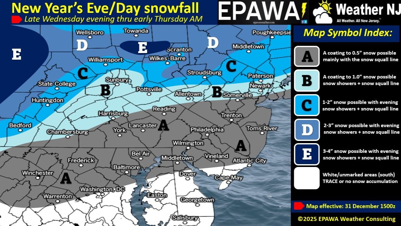
Snowfall Amounts Vary Sharply by Location
Forecast maps indicate sharp contrasts in snowfall totals across the region:
- Southern Pennsylvania and southern New Jersey are expected to see a coating up to 0.5 inches, mainly from the snow squall itself.
- Central and eastern Pennsylvania into northern New Jersey may receive up to 1 inch, combining evening snow showers and the overnight squall.
- Northern Pennsylvania, including areas near State College, Williamsport, Scranton, and Wilkes-Barre, could see 1 to 3 inches due to additional snow showers before the squall arrives.
- Far northern zones, where snow showers are more persistent, may reach 3 to 4 inches in total accumulation.
While these amounts are not extreme by winter standards, the short time frame in which snow falls is the primary concern.
Timing of the Snow Squall Line
The snow squall line is expected to arrive in stages overnight:
- Late evening to around 1 a.m. in north-central Pennsylvania
- Between 1 a.m. and 3 a.m. across central Pennsylvania
- Between 3 a.m. and 5 a.m. for eastern Pennsylvania, including the Reading and Allentown areas
- Between 5 a.m. and 7 a.m. across northern and central New Jersey, including the Philadelphia metro suburbs and coastal plain
Some southern New Jersey and coastal areas may not see the squall until after 7 a.m., or may experience little accumulation before it passes.
Why This Snow Event Is Especially Dangerous
Snow squalls are known for producing near-whiteout conditions in a matter of minutes. Even where only half an inch to one inch of snow falls, roads can become slick and snow-covered almost instantly, especially if temperatures are already near or below freezing.
The timing — overnight into early morning on New Year’s Day — raises additional concerns for holiday travelers, overnight workers, and early commuters, many of whom may not expect sudden winter conditions.
Travel and Safety Impacts
Drivers are urged to use extreme caution during the overnight hours, particularly on interstates, bridges, and untreated secondary roads. Visibility may drop sharply as the squall moves through, increasing the risk of chain-reaction accidents.
Even after the snow stops, rapid temperature drops behind the cold front could allow moisture on roadways to freeze, extending hazardous conditions beyond the snowfall itself.
What to Expect After the Squall Passes
Once the snow squall moves through, conditions will improve quickly in terms of snowfall, but cold air will settle in, keeping surfaces icy in spots. Northern areas that received snow earlier in the evening will retain higher total accumulations compared to southern zones.
As the region transitions into New Year’s Day, winter conditions will remain in place despite the brief nature of the snowfall.
As eastern Pennsylvania and New Jersey ring in 2026, this short-lived but high-impact snow squall serves as a reminder that even small snow amounts can cause major disruptions when they arrive suddenly. For continued coverage of weather events affecting travel, public safety, and regional activity, stay with ChicagoMusicGuide.com.