
New York and Connecticut Face Potential Winter Storm as Snow Band Setup Targets Northeast From Dec. 26–27
NEW YORK – A developing winter storm system is drawing close attention across New York, Connecticut, and parts of the Northeast, with meteorologists warning that Friday into Saturday (December 26–27, 2025) could bring a narrow but potentially intense band of snowfall, mixed precipitation, and rapidly changing conditions.
Forecast data and scenario maps indicate that cold air will be firmly in place, creating a sharp battleground where small shifts in storm track — as little as 50 to 100 miles — could dramatically change snowfall totals for cities and suburbs across the region.
How the Storm Is Expected to Develop
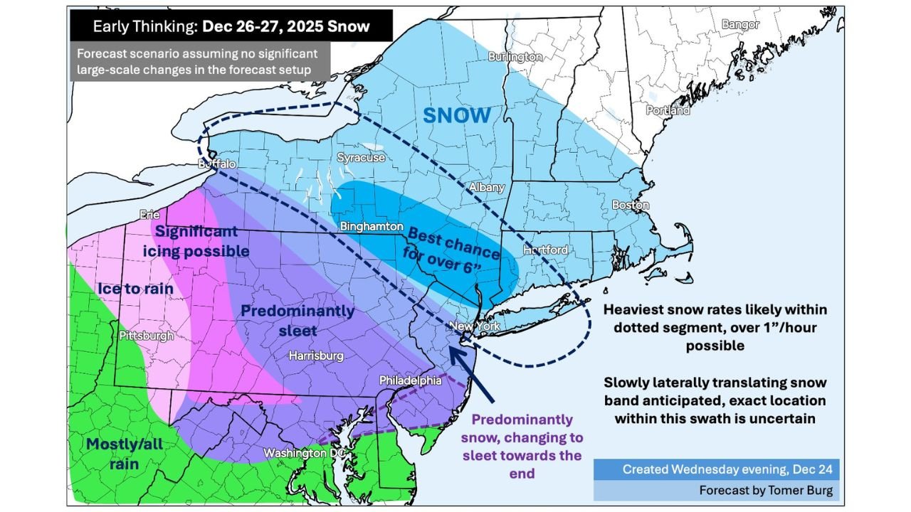
Forecast guidance shows a low-pressure system sliding eastward while encountering entrenched Arctic air over the Northeast. This setup favors the development of a tight, slow-moving snow band, particularly from central New York into southern New England.
Meteorologists caution that this is not a classic widespread snowstorm, but rather a high-impact, narrow swath event where some locations could see several inches of snow while nearby areas receive much less.
Current analysis highlights:
- Best potential for over 6 inches of snow from parts of central New York through interior Connecticut
- Heaviest snowfall rates exceeding 1 inch per hour possible within the most intense band
- Snow band expected to drift slowly, increasing accumulation risk where it stalls
Because of this structure, confidence in exact totals remains limited, but impact potential is significant.
Two Main Scenarios Being Watched
Forecast models continue to show two primary outcomes, both driven by how much cold air dominates as the system arrives.
Scenario 1: Less Snow
- Cold air pushes the storm farther south
- Snow remains light to moderate
- Accumulations stay on the lower end, especially near the coast
- Many areas see manageable impacts
Scenario 2: More Snow
- Moisture stays farther north
- Moderate to heavy snow develops
- Several inches possible, especially inland
- Travel disruptions become more likely
At this stage, Scenario 2 remains a realistic possibility, particularly for interior sections of New York and Connecticut.
Where Snow, Sleet, and Ice Could Mix
In addition to snowfall, forecast maps show mixed precipitation risks:
- Predominantly snow north of the primary band
- Snow changing to sleet farther south and east late in the event
- Icing potential west of the main snow zone, especially across parts of Pennsylvania and western New York
This transition zone is especially important because sleet and ice can limit snowfall totals while increasing travel hazards.
Timing and Impacts
Current timing expectations include:
- Snow developing Friday afternoon or evening
- Heaviest impacts Friday night into early Saturday
- Gradual tapering Saturday morning or early afternoon
Road conditions could deteriorate quickly during peak snowfall rates, especially where temperatures remain well below freezing, allowing snow to accumulate efficiently.
Why Forecast Confidence Is Still Limited
Forecasters stress that synoptic-scale details are not fully locked in, meaning:
- Exact placement of the snow band remains uncertain
- Small atmospheric shifts could move heavy snow north or south
- Final snowfall maps may change closer to the event
This uncertainty is typical for narrow-band winter storms, which often do not resolve clearly until 24–36 hours before impact.
What Residents Should Do Now
Residents across New York and Connecticut are encouraged to:
- Monitor updated forecasts through the week
- Prepare for possible Friday night travel disruptions
- Plan for rapidly changing road conditions
- Stay flexible with weekend plans in case snowfall totals increase
As this winter system continues to evolve, additional updates are expected as confidence improves. For continued weather coverage and storm updates, stay connected with ChicagoMusicGuide.com.