
New York, Pennsylvania and Massachusetts See 30%–50% Odds of 3+ Inches as Sunday–Monday Snowstorm Signals Strengthening Trend
NEW YORK, NEW YORK — Confidence is gradually increasing in a potential Sunday into Monday winter storm, with new model guidance showing a 30%–50% probability of more than 3 inches of snow across portions of New York, Pennsylvania, Massachusetts, and southern New England. While the system remains six days away, forecasters say the rising probabilities make this setup one worth close monitoring.
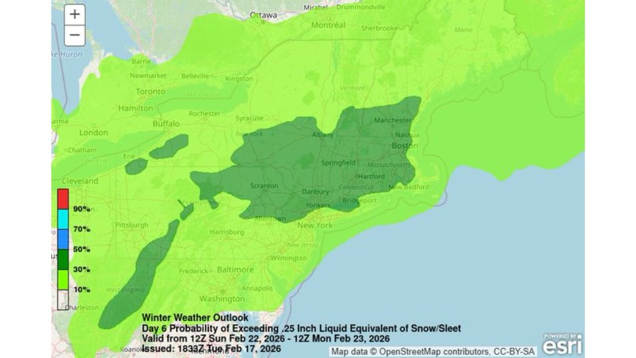
The latest outlook highlights a broad corridor of enhanced snow potential stretching from parts of the Mid-Atlantic through interior New England.
Snow Probabilities Increasing Across the Northeast
The Day 6 winter weather outlook shows a growing area of moderate probability for accumulating snow between Sunday, February 22 and Monday, February 23.
Higher-end probabilities — shaded in darker green — extend from:
- Central and eastern Pennsylvania
- Southern and central New York
- Western and central Massachusetts
- Parts of Connecticut and southern Vermont
Major metro areas including Albany, Springfield, Hartford, Scranton, and portions of the New York City metro region fall within the 30%–50% probability zone for at least 3 inches of snow.
Farther south into Maryland and Washington, D.C., probabilities appear lower but not zero, depending on eventual storm track and temperature profiles.
Why the Odds Are Rising
Forecast models are increasingly aligning around the idea of a developing low-pressure system tracking somewhere near the East Coast late Sunday into Monday.
As guidance updates have come in, the probability of a measurable snowfall event has increased compared to earlier projections. That trend suggests improved agreement among ensemble members regarding storm development.
However, six days remains a long lead time in meteorology. Forecasters caution that small changes in track or intensity could shift the heaviest snow axis significantly north or south.
Interior New York and Pennsylvania Favored
Based on the current outlook, interior regions appear slightly more favored than immediate coastal areas.
Cities such as Albany, Syracuse, Scranton, and Springfield are positioned within higher-probability shading compared to coastal New York City and Boston, where temperature and track sensitivity remain key questions.
If the storm tracks slightly inland, mixing could reduce snowfall along parts of the I-95 corridor. If it tracks offshore and intensifies, snow totals could increase farther east.
What Still Needs to Be Resolved
Several critical forecast variables remain uncertain:
- Exact low-pressure track
- Timing of coastal transfer
- Placement of the rain-to-snow line
- Storm intensification rate
- Strength of cold air in place
A 50–100 mile shift in track could dramatically alter outcomes from Philadelphia to Boston.
Forecasters emphasize that probability maps show potential — not guarantees. The 30%–50% range indicates a meaningful but not certain risk of 3+ inches.
Sunday–Monday Impact Window
The primary window for impact remains Sunday afternoon through early Monday, though exact timing will become clearer later this week.
Travel disruptions could occur across portions of Pennsylvania, New York, Massachusetts, and Connecticut if snow develops as currently suggested.
For now, this remains a monitoring situation rather than a confirmed snowstorm.
As updated model runs continue to refine the storm’s path, ChicagoMusicGuide.com will provide detailed forecast analysis and regional snowfall updates. For continued coverage of Mid-Atlantic and Northeast winter weather, visit ChicagoMusicGuide.com.