
New York, Pennsylvania and New England in the Crosshairs as National Weather Service Flags Potential Heavy Snow Sunday Night Into Monday
NEW YORK — The National Weather Service is highlighting the potential for heavy snow Sunday into Monday, with Sunday night identified as the main period of interest, across parts of New York, Pennsylvania, and New England. While forecast models only recently began trending snowier, forecasters say it remains unclear whether this shift is a short-term fluctuation or the beginning of a more significant winter storm setup.
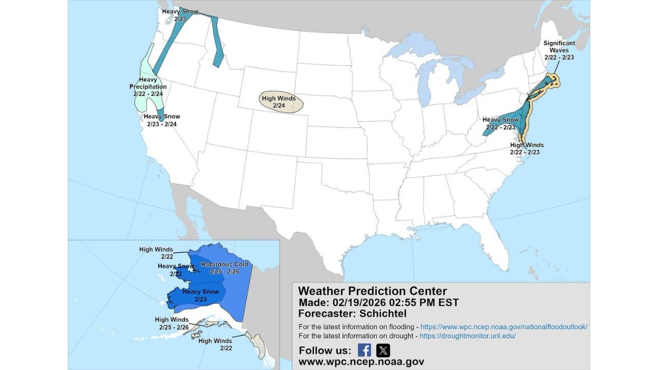
The updated Day 3–7 U.S. Hazards Outlook (valid February 22–26, 2026) shows a focused heavy snow area stretching from portions of the Mid-Atlantic into interior New England, paired with high wind concerns and coastal wave impacts.
Heavy Snow Zone Targets Interior Northeast
The outlook map highlights a heavy snow risk from February 22–23, covering:
- Interior Pennsylvania
- Much of upstate New York
- Parts of Vermont, New Hampshire, and Maine
- Northern sections of Massachusetts
The corridor suggests the greatest accumulation potential will likely favor inland areas rather than immediate coastal zones. However, even slight shifts in the storm track could significantly impact snowfall totals in major metro areas including Albany, Buffalo, Syracuse, Hartford, and Boston.
Forecasters emphasize that Sunday night appears to be the window when conditions could intensify.
High Winds and Coastal Concerns
In addition to snowfall, the outlook flags:
- High winds (February 22–23) along portions of the Northeast coastline
- Significant waves (February 22–23) for coastal New England
This combination raises the possibility of reduced visibility during heavy snow bands and difficult travel, particularly if strong gusts overlap with peak precipitation rates.
Coastal communities in Massachusetts and Maine may need to monitor wave action and shoreline impacts as the system strengthens offshore.
Western U.S. and Alaska Also Impacted
The broader hazards map shows active weather elsewhere in the country:
- Heavy precipitation in California (February 22–24)
- Heavy snow in the Cascades and Northern Rockies
- High winds in parts of the central Plains (February 24)
- Heavy snow and hazardous cold across Alaska
While the focus in the eastern U.S. is on snow potential, the national pattern remains highly dynamic from coast to coast.
Why Forecasters Are Cautious
Meteorologists note that afternoon model runs have “gently gone in a snowier direction,” but it remains uncertain whether that signal is consistent.
The key questions still being evaluated:
- Will cold air hold firmly across interior Northeast states?
- How close will the storm track approach the coast?
- Will mixing reduce totals near coastal cities?
Another round of updated model guidance is expected late Thursday night, which could either reinforce the heavy snow signal or shift expectations.
Sunday Night: The Critical Window
If current projections hold, Sunday night into early Monday morning would be the most impactful timeframe for:
- Rapid snowfall accumulation
- Slick roads and hazardous travel
- Reduced visibility in heavier bands
Early indications suggest that interior elevations and colder valleys would have the highest confidence for significant snow.
What Residents Should Watch For
Residents across Pennsylvania, New York, Vermont, New Hampshire, Massachusetts, and Maine should monitor:
- Updated snowfall projections
- Wind advisories or watches
- Potential winter storm watches by late Friday or Saturday
Forecast confidence is still evolving, but the signal for a more organized winter system is growing stronger.
As the Northeast prepares for a possible late-February snowmaker, all eyes now turn to the next round of model data. ChicagoMusicGuide.com will continue tracking developments as the Sunday–Monday window approaches and clearer snowfall projections emerge.