
New York, Pennsylvania, New Jersey and Massachusetts Face Potential 18–24 Inch Blizzard as 2/22–23 Nor’easter Targets I-95 Corridor
NEW YORK CITY, NEW YORK — A strengthening Nor’easter expected Sunday into Monday, February 22–23, is raising the possibility of a significant winter storm from Washington, D.C. through Philadelphia, New York City, Hartford, Providence, and Boston, with some coastal areas projected to receive 18–24 inches of snow and potential blizzard conditions.
Forecasters describe this as a “first call” forecast, but confidence is growing that a strong coastal low will track close enough to the shoreline to bring widespread impacts across the Mid-Atlantic and Northeast.
Why This Nor’easter Could Become a Major Blizzard
Atmospheric setup is playing a major role in this forecast. A strengthening ridge over Montana and Idaho is helping carve a deep trough across the Eastern United States. That pattern allows the developing coastal low to intensify rapidly as it moves north and northeast Sunday night.
Forecast discussion suggests the storm could tuck near the coast of New Jersey and Long Island overnight Sunday before lifting toward southern New England Monday evening. If that occurs, strong frontogenesis in the mid-level atmosphere would support snowfall rates of 2–3 inches per hour in heavier bands.
With sustained winds near 20 mph and gusts potentially reaching 40 mph, especially along the coast, localized blizzard conditions could develop east of I-95.
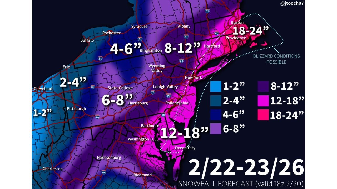
Snowfall Forecast by Region: 2/22–23/26 Storm
The projected snowfall map highlights a sharp gradient from west to east:
- 1–2 inches in parts of eastern Ohio and far western Pennsylvania
- 2–4 inches around Cleveland, Erie, and nearby western zones
- 4–6 inches across upstate western New York and portions of interior Pennsylvania
- 6–8 inches around Harrisburg, the Lehigh Valley, and central Pennsylvania
- 8–12 inches from Albany to Hartford and interior southern New England
- 12–18 inches across Washington, D.C., Baltimore, Philadelphia, and coastal New Jersey
- 18–24 inches from New York City to Providence and Boston, especially along coastal Massachusetts
The highest totals are concentrated near and east of the I-95 corridor, where the storm’s coastal track enhances snowfall and wind intensity.
Blizzard Conditions Possible Along Coastal New Jersey and Massachusetts
A highlighted zone along the coast indicates where blizzard conditions may be possible. This includes portions of:
- Long Island
- Coastal New Jersey
- Coastal Connecticut and Rhode Island
- Eastern Massachusetts, including the Boston metro
If the storm strengthens rapidly offshore, visibility could drop below one-quarter mile during peak snowfall, especially where winds align with heavier bands.
Coastal erosion and minor flooding are also possible due to strong onshore winds.
Key Forecast Uncertainties Over the Next 24–36 Hours
While confidence is high in a strong storm, several factors could still adjust snowfall totals:
- How close the low tracks to the coastline
- The speed at which the system intensifies
- Placement of the inverted trough and strongest snow bands
- Temperature profiles near the immediate coastline
A slightly farther offshore track would reduce totals inland. A closer or stronger storm would expand heavier snow farther west into central Pennsylvania and potentially increase totals in Washington, D.C. and Baltimore.
Forecasters emphasize that adjustments are likely before final snowfall maps are issued.
Impacts from Sunday Afternoon Through Monday
Snow is expected to begin Sunday, intensify overnight, and continue into Monday daytime across parts of New York, Pennsylvania, New Jersey, Connecticut, Rhode Island, and Massachusetts.
Potential impacts include:
- Dangerous travel along I-95, I-78, I-84, I-90, and regional highways
- Flight delays in major hubs including New York City and Boston
- Metro and rail disruptions
- Power outages in areas with heavy, wind-driven snow
Residents are encouraged to begin preparations now regardless of final totals.
With this 2/22–23 winter storm still evolving, ChicagoMusicGuide.com will continue monitoring updated snowfall forecasts and potential event disruptions across the Northeast as the Nor’easter approaches.