
New York, Pennsylvania, New Jersey, Connecticut, and Massachusetts Face Slushy Snow and Icy Commutes as Coastal System Moves Through the Northeast
UNITED STATES — Forecast data and high-resolution model guidance show a late-December winter weather system impacting a broad swath of the Northeast and Mid-Atlantic, bringing a brief period of snow, freezing rain, and slushy conditions before a transition to rain in warmer areas. While this is not expected to be a major snowstorm, timing during the early-morning commute and sharp temperature contrasts will create travel concerns across multiple states.
Pennsylvania: Freezing Rain Southwest, Higher Snow Northeast
Across Pennsylvania, forecast confidence is high that freezing rain and ice are most likely in southwestern portions of the state, where temperatures are expected to remain near or just below freezing during the onset of precipitation. Ice probabilities generally range from 40–60%, creating the potential for slick roads and sidewalks.
In contrast, northeastern Pennsylvania is favored for heavier snowfall, with snow probabilities exceeding 70–85% in areas north and east of Scranton and toward the higher terrain. Central Pennsylvania sits in a mixed-precipitation zone, where snow may briefly accumulate before changing to sleet or rain, resulting in slushy but mostly wet roadways.
Maryland and the Baltimore Region: Mostly Wet, Limited Snow
In central Maryland, including the Baltimore area, temperatures are expected to remain above freezing, significantly limiting snowfall potential. Forecast guidance indicates that only brief slushy snow is possible near and north of Baltimore, with most roads staying wet.
However, near-freezing conditions closer to York, Pennsylvania, and points east increase the chance for a light coating on untreated surfaces. Below-freezing temperatures extend farther north into the Poconos, Lehigh Valley, New York metro area, and New England, where winter impacts become more pronounced.
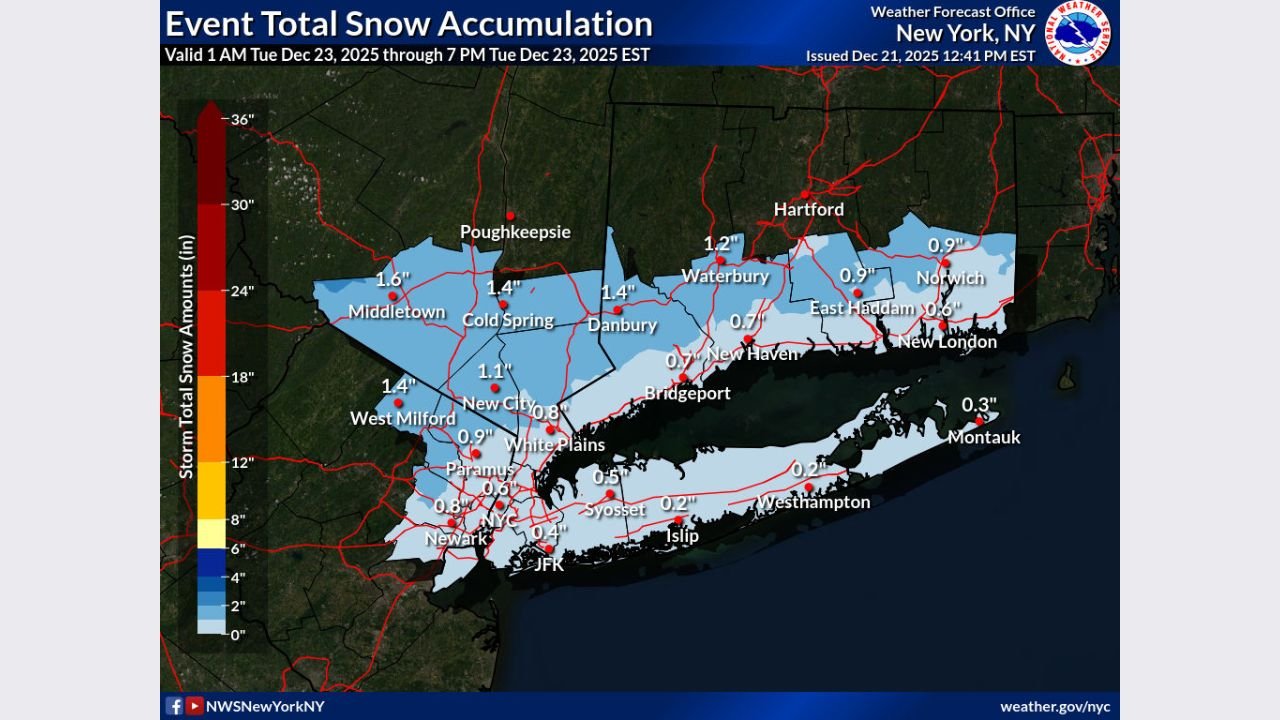
New York: Early Snow, Then Rain
In New York, light snow is expected to develop very early in the morning, roughly between 4 and 5 a.m., before changing to rain by around 8 a.m. as temperatures rise. Snowfall totals are expected to remain under 1 inch near New York City, with 1 to 3 inches possible farther north and west, including parts of the Hudson Valley and interior southern New York.
Roads and sidewalks may become slushy and potentially icy during the morning commute, particularly before the changeover to rain. Emergency officials stress allowing extra travel time and exercising caution while walking or driving.
New Jersey and Connecticut: Light Snow Inland, Rain Near the Coast
In New Jersey, snowfall amounts are expected to be minor, with coatings to under 1 inch common, especially inland. Coastal sections are more likely to see rain dominate quickly, keeping accumulations limited.
Connecticut follows a similar pattern. Interior locations may see around 1 inch of snow, while coastal areas experience a faster transition to rain. Snow probabilities increase farther north, with moderate accumulation chances in higher-elevation areas.
Massachusetts and New England: Colder Air Supports More Snow
Colder air across Massachusetts and southern New England supports greater snowfall potential, particularly north and west of Boston. Forecast data suggests 1 to 3 inches are possible in these areas, while coastal zones remain closer to rain or a rain-snow mix. Below-freezing temperatures increase the likelihood of snow sticking, especially on untreated surfaces.
Snow and Ice Probabilities Highlight Key Risk Zones
Probability maps show:
- Ice probabilities of 40–60% across parts of southwestern and central Pennsylvania
- Snow probabilities of 70–88% in northeastern Pennsylvania, interior New York, and parts of New England
- Lower snow probabilities (under 50%) closer to coastal areas, including New York City, southern New Jersey, and coastal Connecticut
These probabilities reinforce that small temperature differences will strongly influence impacts, especially near the rain-snow line.
Travel Impacts Along the I-95 Corridor
While snowfall totals remain modest, travel impacts are expected along the I-95 corridor, particularly through New York City and Boston, where brief snow or ice during peak commute hours could slow traffic. Forecast guidance highlights more snow north and west of major cities, while urban cores deal mainly with slush and wet pavement.
What Residents Should Know

- Snow develops late Monday night into early Tuesday morning
- Rain replaces snow in warmer areas by mid-morning
- Most accumulations remain under 3 inches
- Icy sidewalks, bridges, and untreated roads remain the primary hazard
- Forecasts may still change, and residents are urged to monitor updates
As this system moves through, officials emphasize preparedness rather than alarm. Even light snow and ice, when timed with the morning commute, can cause outsized disruptions.
Stay with ChicagoMusicGuide.com for continued coverage of weather systems that impact travel, events, and daily life across the United States.