
Nor’easter Blizzard Threat Targets Boston, New York City, and Hartford With 12+ Inches Possible
NEW YORK CITY, NEW YORK — A strengthening Nor’easter is increasingly signaling a high-impact winter setup for the Northeast, with heavy snow and strong winds possible from Sunday into Monday. Forecast guidance highlights a corridor where Boston, New York City, and Hartford could see 12 inches or more, creating the kind of conditions that can quickly turn travel dangerous and cause widespread delays.
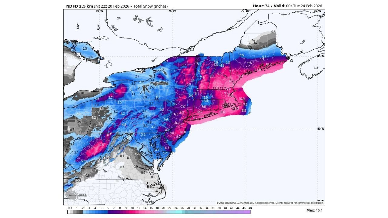
What The Snow Map Shows Right Now Across The Northeast
Current snowfall projections show the highest totals focused from parts of Pennsylvania and New Jersey through New York, Connecticut, Rhode Island, and into sections of Massachusetts. In the most intense banding zones, totals climb into the 12–16 inch range, a signal that this could be a major storm if the track stays locked in.
The heaviest snow appears most likely near and just inland from key population centers, where storm dynamics often intensify snowfall rates. That matters because a smaller shift in the storm’s path can move the highest totals either closer to the coast or farther inland, changing impacts for cities like New York City and Boston with little notice.
Blizzard Conditions Are Possible If Winds Increase As Expected
A storm doesn’t need record-breaking snowfall to become a major problem. If high winds overlap the heaviest snow, visibility can drop rapidly and drifting can make roads impassable—especially during peak travel windows. The current setup supports a scenario where blizzard-like conditions become possible in parts of the region, particularly where snowfall is heavier and wind gusts are strongest.
For the I-95 corridor, the biggest risk is timing. Snow beginning late weekend and continuing into Monday could collide with airport and commuter schedules, triggering flight cancellations, train delays, and slowdowns on major highways. Even areas that land closer to the 6–10 inch range could still see major disruption if snowfall rates become intense for several hours.
Cities Most At Risk For 12+ Inches and Major Disruption
Based on the current projected snow shield, a broad zone of significant accumulation includes New York City, Hartford, and portions of Boston’s metro area, with surrounding communities across Connecticut and Massachusetts also in a favored area for heavier totals. Some of the most impactful snowstorms in the Northeast are driven by narrow “bands” that set up and produce extreme snowfall over short distances.
That means one town can end up with 6 inches, while another just 20–30 miles away records 12–16 inches. If the storm strengthens quickly offshore, coastal and near-coastal areas—especially around Long Island, southern New England, and parts of Rhode Island—could see rapidly changing conditions with blowing snow and difficult driving.
How This Could Affect Travel, Power, and Weekend Events
The combination of heavy snow, possible high wind gusts, and falling temperatures can create a chain reaction across the region. Roads can become hazardous quickly, particularly during periods of heavier snowfall where plows cannot keep up. Bridges, overpasses, and untreated surfaces can turn slick first, and visibility can drop sharply if winds increase.
For the live entertainment world, storms like this can also cause last-minute changes. Venue schedules, tour routing, and Sunday-night events may be impacted if travel becomes unsafe or if transit systems scale back service. Fans planning to attend shows in New York, Connecticut, Massachusetts, or nearby states should keep a close watch on local updates and be ready for schedule adjustments tied to road conditions.
If winds strengthen enough, the risk of scattered power outages rises—especially where snow is wetter and heavier, or where gusts bring down tree limbs. Even short outages can lead to heating concerns and additional travel complications across dense metro areas.
Smart Preparation Steps Before Snow and Wind Ramp Up
If you are in or traveling through New York, Connecticut, Rhode Island, Massachusetts, or nearby areas, it’s worth preparing now—before conditions deteriorate. The goal is to avoid being forced onto the roads when snow rates increase or visibility drops.
Here are practical steps that can help ahead of Sunday into Monday:
- Keep phones and battery packs fully charged in case of outages
- Stock water, nonperishable food, and any needed medications for 1–2 days
- If you must drive, keep an emergency kit: blanket, flashlight, snacks, and ice scraper
- Watch for updates on snow totals and wind forecasts, especially if you’re near the coast
- Plan flexible travel options in case flights or train service is delayed
The most important detail right now is that this remains a developing forecast. A storm track shift can raise totals for one city while lowering them for another, so staying aware through the weekend will be key—especially for those in the likely heavier-snow zone from New York City toward Hartford and parts of Boston’s region.
As this Nor’easter threat becomes clearer, keep checking back for the latest storm-impact updates that matter to travelers and music fans alike—including how snow, wind, and Monday delays could affect plans across the Northeast. For continued coverage of major weather disruptions and the events they impact, visit ChicagoMusicGuide.com.