
North Carolina and South Carolina Snowstorm Reveals Forecast Hits and Misses as I-85 and I-77 Corridors Overperform
UNITED STATES — A late-January winter storm that impacted North Carolina and South Carolina between January 31 and February 1, 2026, delivered sharply uneven snowfall results, with some regions closely matching forecasts while others significantly over- or underperformed. A post-storm verification comparing forecast maps to preliminary snow totals shows clear successes in eastern North Carolina, major busts across much of South Carolina, and a striking overperformance along the I-85 and I-77 corridors in North Carolina.
Forecasters described the event as a long-duration system that ultimately lacked the widespread heavy snow banding many models suggested, leading to highly localized outcomes across the Carolinas.
Eastern North Carolina Forecast Verifies Strongly
Across eastern North Carolina, snowfall totals aligned closely with pre-storm expectations. Coastal and near-coastal areas generally fell within forecast ranges, validating the spatial placement of the heaviest snow bands.
Cities such as Greenville, Havelock, and parts of the Inner Banks recorded significant accumulations that matched or slightly exceeded forecast guidance. Some coastal locations exceeded 10 inches, with localized totals approaching 14 inches, particularly where mesoscale banding persisted longer than expected.
Forecasters noted that while totals locally exceeded projections, the overall spatial accuracy of the forecast in eastern North Carolina was strong, earning high marks for placement even where amounts ran high.
South Carolina Sees the Biggest Forecast Bust
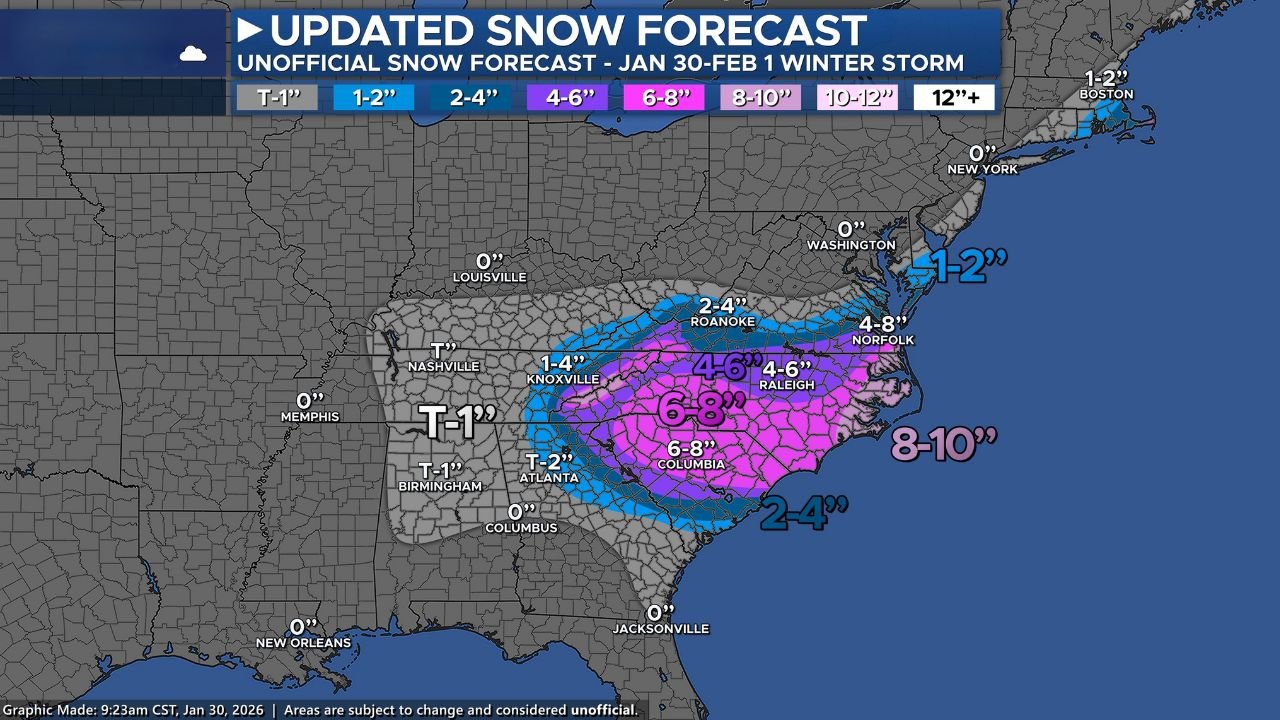
In South Carolina, the storm produced the largest discrepancy between forecast expectations and reality. Many forecast models had suggested 6 to 8 inches or more across large portions of the state, but that level of snowfall failed to materialize outside isolated areas.
Much of the state underperformed due to the absence of sustained heavy snow banding, despite favorable cold air and sufficient storm duration. While snowfall did occur statewide, totals were generally lower than expected, especially away from the northeastern corner of the state.
An exception occurred near the I-95 corridor, where a drier slot — mentioned in forecast discussions but not clearly reflected on maps — limited snowfall accumulation and reduced totals more than anticipated.
I-85 and I-77 Corridors in North Carolina Massively Overperform
The most striking outcome occurred along the I-85 and I-77 corridors in North Carolina, where snowfall significantly exceeded forecasts. Areas from Charlotte northward through the Piedmont recorded 8 to 12 inches of snow, surpassing the forecast range of 6 to 8 inches.
Cities including Charlotte, Greensboro, Lexington, and surrounding communities experienced persistent snow bands that remained nearly stationary for hours. These bands delivered prolonged moderate to heavy snowfall, rapidly boosting totals beyond expectations.
Forecasters acknowledged that this corridor’s performance surprised not only local meteorologists but many regional forecasting teams, underscoring the challenges of predicting mesoscale snow features.
Smoky Mountains and Western North Carolina Also Outperform
The Smoky Mountains and western North Carolina also outperformed forecasts, driven by a very early onset of snow and enhanced moisture flow into higher elevations.
Mountain locations benefited from upslope enhancement, resulting in heavier snow totals than initially projected. The early start allowed snow to accumulate before any marginal temperature issues could develop, maximizing accumulation potential across the region.
These combined factors produced totals well above guidance in portions of Sevier, Haywood, and surrounding mountain counties.
Trace and Light Snow Zones Highlight Forecast Challenges
In areas forecast for only trace to light accumulations, verification proved especially difficult. Light snow bands are notoriously challenging to pinpoint, and slight north-south shifts resulted in some locations missing even minor accumulations, while others unexpectedly picked up measurable snow.
Forecasters noted that predicting the exact placement of these light bands remains one of the most complex aspects of winter forecasting, particularly within 12 hours of an event.
Overall Storm Grade: Solid but Imperfect
Overall, forecasters assigned themselves a B- grade for the event. While snowfall amounts varied sharply, the spatial forecast accuracy generally outperformed raw accumulation forecasts.
The team emphasized that conservative snowfall forecasting — a deliberate strategy — likely contributed to notable overperformance in some areas, while others underperformed due to missing mesoscale features.
This storm serves as another reminder that even with advanced modeling, mesoscale winter weather features remain extremely difficult to forecast with precision, especially across the complex terrain and coastal influences of the Carolinas.
As winter patterns remain active across the Southeast, this storm will likely be studied as a textbook example of how small-scale atmospheric processes can dramatically reshape snowfall outcomes. For continued coverage of winter storms, forecast verification, and regional weather analysis, visit ChicagoMusicGuide.com.