
North Carolina, South Carolina, and Georgia See Low-Impact Sunday Snow Potential as Rain Briefly Mixes Inland
UNITED STATES — A weak winter weather system moving across the Southeast on Sunday is expected to bring mainly rain with a brief rain-to-snow mix across parts of North Carolina, South Carolina, and eastern Georgia, according to the latest forecast data and regional weather briefings. While snowflakes may be visible in some inland areas during the late morning and early afternoon, forecasters emphasize that this setup remains low-impact, with little to no meaningful accumulation expected.
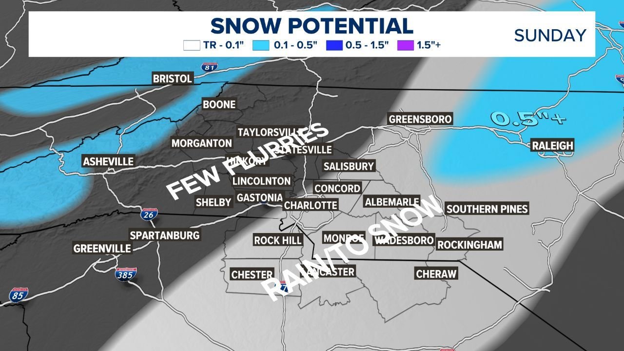
What the Forecast Shows for the Carolinas and Georgia
Forecast guidance indicates that precipitation will begin as rain across most of the region, especially closer to the coast and along major population centers. As colder air filters in behind a departing system, a brief transition to a rain/snow mix or light snow may occur inland, particularly west of the I-85 corridor and away from the immediate coastline.
Even in areas where snow briefly falls, surface temperatures are expected to remain above freezing for most of the day, limiting the ability for snow to accumulate. The highest probabilities for seeing snowflakes remain in parts of central and western North Carolina, upstate South Carolina, and far inland southeast Georgia, but forecast probabilities generally range from 40 to 50 percent for any measurable snow.
Snow Accumulation and Travel Impacts Remain Minimal
Model guidance and local forecast graphics consistently show trace amounts to at most around 0.1 to 0.5 inches in isolated spots, mainly on grassy surfaces, elevated roadways, and bridges. The majority of locations are expected to see no accumulation at all.
Because daytime temperatures are forecast to hold in the upper 30s to lower 40s, travel impacts are not anticipated. Roads should remain mostly wet, not snow-covered, and no widespread closures or disruptions are expected. Meteorologists stress that this event is not a shovel-ready snowstorm and does not resemble the larger winter systems sometimes advertised on social media.
Timing of Rain and Snow Mixing on Sunday
The timing window for any snow is relatively short. Rain develops early Sunday morning, with the rain-to-snow mix most likely between late morning and early afternoon as colder air briefly deepens behind the system. In most areas, precipitation tapers off by mid-afternoon.
Later Sunday night, skies are expected to clear as temperatures drop. While this could allow patchy black ice to form in isolated spots, especially on bridges and untreated surfaces, steady winds and lowering humidity may limit widespread icing concerns.
Why This System Is Being Overhyped Online
Forecasters note that global and regional weather models are in strong agreement on the low-impact nature of this setup. Despite circulating “snow maps” suggesting several inches of accumulation, the atmospheric setup does not support a significant winter storm.
Key limiting factors include:
- Above-freezing surface temperatures
- Warm ground conditions
- Short-lived cold air
- Limited precipitation intensity
As a result, any snow that does fall is expected to be brief, light, and mostly cosmetic rather than disruptive.
What Residents Should Expect Overall
For most people across North Carolina, South Carolina, and Georgia, Sunday will feel more like a cold, damp winter day than a true snow event. Some locations may see fun flakes or a brief novelty burst of snow, but no meaningful accumulation and no major travel issues are expected.
The most important takeaway is that this is a low-impact system, and residents should not change plans based on snow concerns. Staying aware of local updates is always encouraged, but confidence in the forecast remains high.
As always, ChicagoMusicGuide.com will continue tracking winter weather patterns across the United States and provide clear, data-driven updates as conditions evolve.