
Pennsylvania, Maryland, Delaware and New Jersey in Crosshairs as Coastal Low Targets Narrow Heavy Snow Bands With Potential Blizzard Conditions
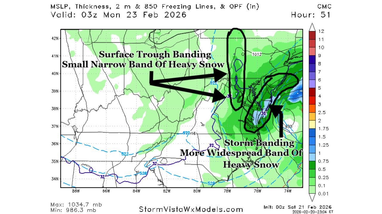
PHILADELPHIA, PENNSYLVANIA — A developing coastal storm is sharpening its focus on Pennsylvania, Maryland, Delaware, and New Jersey, with forecasters closely watching two distinct heavy snow zones that could determine where the biggest totals fall Sunday into Monday. Early model analysis highlights both a widespread storm banding zone near the Eastern Shore and coastal Mid-Atlantic and a narrow but intense surface trough band on the storm’s western flank.
The setup suggests that whoever lands directly under these banding features could see significantly higher snowfall totals than surrounding areas.
Two Heavy Snow Zones Could Drive “Boom” Totals
Forecast guidance, including the 0z Canadian model example, shows two primary areas of concern:
- Surface Storm Intensification Banding (Eastern Shore Focus)
Most models favor the Eastern Shore of Maryland and Delaware, extending northward toward southern New Jersey, for stronger storm-driven banding. This would result in a broader area of heavy snow along the coastal plain. - Inverted Surface Trough Deformation Band (Western Flank)
A second, much narrower band of heavy snow is projected somewhere west of the main coastal low track. This “deformation band” could set up from central Maryland into eastern Pennsylvania and possibly northern New Jersey, delivering intense snowfall rates in a tight corridor.
The exact placement of this narrow band remains uncertain, but wherever it locks in, snowfall totals could rapidly exceed baseline projections.
Eastern Pennsylvania and Central Maryland on Alert
The model depiction shows the heavier storm banding lifting northward from Virginia into Maryland and Delaware, then continuing toward southern New Jersey and southeastern Pennsylvania. Areas east of Interstate 81 in Pennsylvania appear especially vulnerable if the system trends slightly northwest.
Cities such as:
- Philadelphia, PA
- Reading, PA
- Lancaster, PA
- Baltimore, MD
- Wilmington, DE
could find themselves in the higher-end snowfall corridor depending on how quickly the northern and southern energy streams phase.
A slight shift of even 25–50 miles could dramatically change totals between central Pennsylvania and eastern Pennsylvania.
Blizzard Conditions Possible Along the Coast
Along the Atlantic coastline from Delaware through coastal New Jersey, blizzard conditions remain possible if the storm deepens and tucks closer to shore. Strong winds wrapping around the low pressure system may combine with heavy snowfall to create:
- Whiteout conditions
- Drifting snow
- Coastal travel shutdowns
- Increased risk of power outages
The closer communities are to the coast, the higher the wind-related risk becomes.
Storm Track and Why Small Changes Matter
Recent trends show a westward adjustment of the ridge axis and quicker phasing between northern and southern energy streams. That configuration favors a coastal low riding northward while throwing heavy snow inland through deformation banding.
However, forecasters note that the system could still tick slightly northwest over the next 48 hours. If that occurs, heavier snow could shift farther inland into eastern Pennsylvania and parts of central Pennsylvania, increasing totals in communities that may not yet expect the highest accumulations.
Conversely, a slight eastward shift would concentrate the most extreme totals closer to the immediate coast.
Timing and Preparation
Snow is expected to intensify Sunday into early Monday, with peak banding likely overnight. Forecasters emphasize that preparation should occur immediately, especially in areas east of I-81 and along the coastal plain.
Residents should plan for potential power outages, hazardous travel, and rapidly changing conditions as banding develops.
This remains a first-call forecast, and final refinements will determine the precise location of the heaviest snow corridor. But confidence is growing that a high-impact winter storm is unfolding across Pennsylvania, Maryland, Delaware, and New Jersey.
For ongoing coverage of this developing East Coast winter storm and updates on travel impacts, continue following ChicagoMusicGuide.com for the latest weather reports.