
Pennsylvania Sees Brief Taste of Spring Tuesday Before Cold Air Quickly Returns Across the State
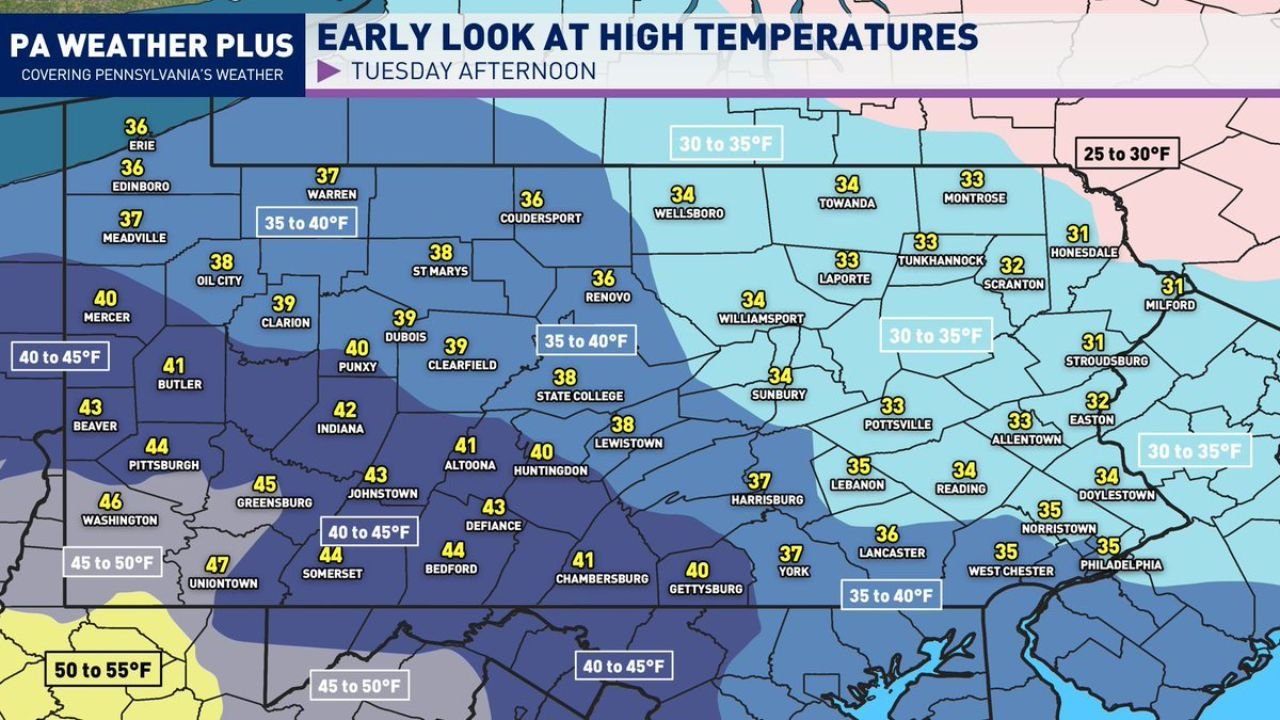
PENNSYLVANIA — After another stretch of frigid winter nights, parts of Pennsylvania are set to experience a brief but noticeable warm-up on Tuesday afternoon, offering what forecasters are calling a short-lived taste of spring. High temperatures are expected to climb into the 30s and 40s statewide, with southwestern Pennsylvania flirting with the 50-degree mark, especially in valley locations.
The warmer air will be temporary, however, as colder conditions are expected to return by midweek, bringing temperatures back down into more typical winter ranges.
Tuesday Expected To Be The Warmest Day Of The Week
Forecast data shows Tuesday shaping up to be the warmest day of the week across Pennsylvania, with a clear west-to-east temperature gradient. Cities across western and southwestern Pennsylvania, including areas near Pittsburgh, Washington, and Greensburg, are forecast to reach the mid to upper 40s, with some pockets approaching 50 degrees.
Central parts of the state, including State College, Altoona, Johnstown, and Harrisburg, are expected to see highs generally in the upper 30s to lower 40s. Meanwhile, northeastern Pennsylvania, including Scranton, Wilkes-Barre, Towanda, and Honesdale, will likely remain cooler, with highs mainly in the low to mid-30s.
This temperature spread reflects lingering cold air across the northeast while milder air briefly pushes in from the southwest.
Snowmelt Likely As Temperatures Rise Above Freezing
One of the most noticeable impacts of Tuesday’s warmer air will be widespread snowmelt. With temperatures finally breaking above the 32-degree freezing mark for many locations, accumulated snow from recent cold spells is expected to begin melting rapidly.
The increasing sun angle this time of year will further accelerate melting, particularly in urban areas and valleys where surfaces warm more efficiently. While no major flooding concerns are currently indicated, residents should remain aware of ponding on roads, wet sidewalks, and refreezing risks once temperatures drop again at night.
This brief thaw may also reveal lingering winter hazards, such as icy patches hidden beneath melting snowbanks.
Cold Air Returns Midweek With Temperatures Falling Again
Despite the spring-like feel on Tuesday, the warmth will not last long. Forecast guidance shows temperatures falling back into the 20s and 30s from Wednesday through Friday, returning much of the state to winter-like conditions.
Daytime highs will trend cooler across all regions, with overnight lows once again dipping well below freezing. Northeastern Pennsylvania is expected to remain the coldest region, while southwestern areas may hold onto slightly milder daytime readings but still fall sharply at night.
The return to colder air means any melted snow could refreeze, creating slick conditions during the early morning and overnight hours later in the week.
What Residents Should Expect Going Forward
For many Pennsylvanians, Tuesday will feel like a welcome break from winter, even if only for a day. The warmer conditions provide a reminder that seasonal change is underway, though winter is far from finished.
Residents are encouraged to take advantage of the milder weather cautiously, keeping in mind that colder air will quickly follow. Dressing in layers, watching for melting and refreezing hazards, and staying updated on daily forecasts will remain important as temperatures fluctuate.
Weather patterns like this are common during late winter, when brief warm spells are often followed by renewed cold before spring fully settles in.
As Pennsylvania enjoys this short-lived warm-up before colder air returns, staying informed will help residents plan for rapidly changing conditions. For continued updates on regional weather trends, seasonal shifts, and how they may impact events and daily life, visit ChicagoMusicGuide.com for the latest forecasts and local coverage.