
Pennsylvania Weekend Snow Forecast Turns Uncertain as ECMWF Trends North While GFS Holds Storm South and Weaker
PENNSYLVANIA — A potential Sunday late afternoon into Monday morning winter system is creating growing forecast uncertainty across Pennsylvania, as two major weather models show notably different outcomes. While early thinking favors a weaker, southern track with little snowfall, recent ECMWF ensemble trends suggest a more amplified system edging farther north.
Forecasters caution that the setup remains volatile, with small shifts in storm timing and structure capable of dramatically changing snowfall projections.
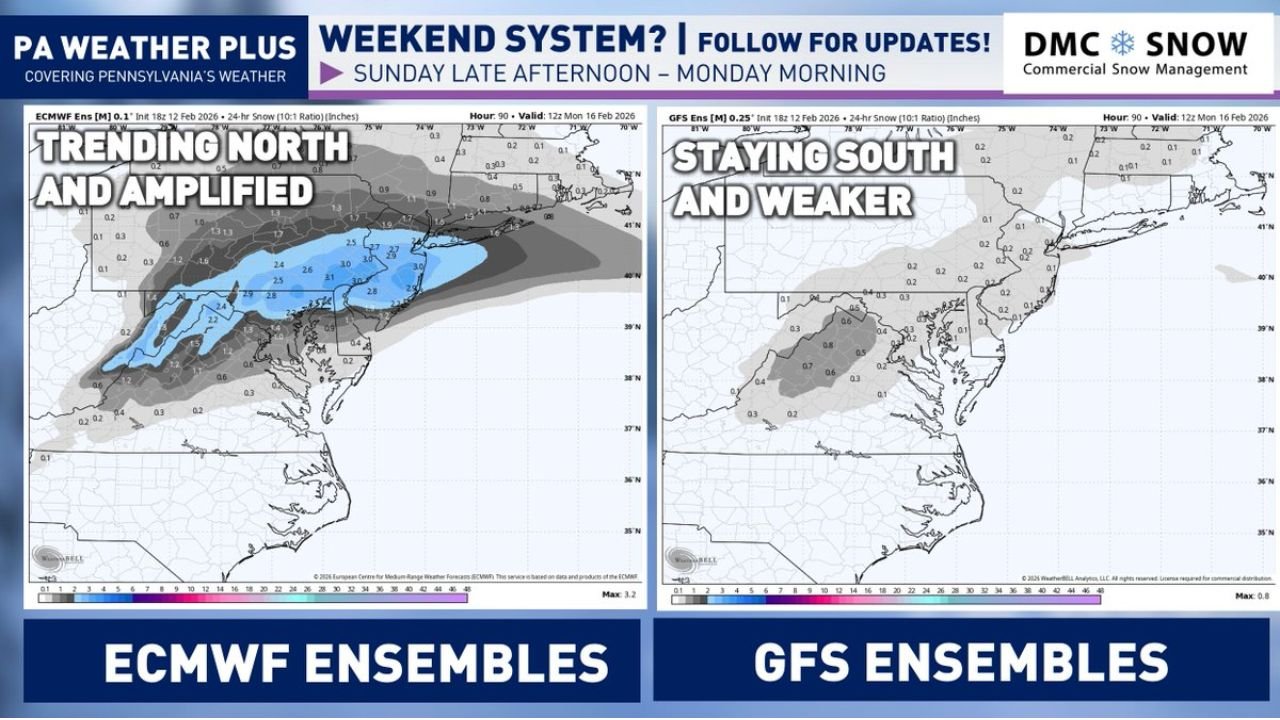
ECMWF Ensembles Trend North and Stronger
The latest ECMWF ensemble guidance, which includes 101 different model members, has gradually amplified the system throughout Thursday’s runs. Compared to earlier projections, more ensemble members now push precipitation farther north into central and eastern Pennsylvania.
Snowfall maps tied to the ECMWF ensemble show a band of measurable snow extending into portions of southern and central Pennsylvania, with some runs suggesting light to moderate accumulation potential if the stronger solution verifies.
Meteorologists use ensemble forecasting to measure uncertainty. When more members cluster around a similar solution, confidence grows. In this case, the ECMWF suite has shown increasing agreement toward a slightly stronger storm track compared to earlier expectations.
GFS Ensembles Remain South and Weaker
In contrast, the GFS ensemble model, which contains 21 members, continues to favor a weaker system staying farther south. Under that scenario, much of Pennsylvania would experience limited impacts, potentially just scattered rain showers or a brief mix with light wet snow.
The difference between the two model families underscores how delicate the atmospheric setup is. A slight shift in storm phasing or track could determine whether parts of Pennsylvania see measurable snowfall or simply light precipitation.
At this stage, many forecasters still lean toward the weaker, southern solution — meaning minimal winter weather for most areas — but the persistent northward nudges in the ECMWF cannot be ignored.
What an Ensemble Forecast Means
An ensemble forecast combines multiple model runs, each starting with slightly different atmospheric assumptions. Rather than relying on one deterministic outcome, meteorologists analyze the spread of possibilities.
If most ensemble members align, confidence increases. If they vary widely, uncertainty remains high. In this case, the ECMWF and GFS ensembles are not fully aligned, which keeps the weekend forecast fluid.
The ECMWF’s 101-member suite provides a broader range of scenarios, while the GFS’s 21-member group presents a more limited sample size. Differences in how each model handles upper-level energy and moisture transport are driving the divergent solutions.
Current Expectations for Pennsylvania
As of the Thursday 9:00 PM update, the most likely scenario still points to a graze across southern Pennsylvania, possibly featuring rain showers with a brief mix of light wet snow late Sunday into early Monday.
Forecasters are not currently expecting a major winter storm. However, given how ensemble trends have shifted during the day, residents are encouraged to monitor updates heading into the weekend.
Small atmospheric changes — especially in the timing and interaction of upper-level disturbances — could significantly alter snowfall totals and storm intensity.
What to Watch Heading Into Sunday
Key factors to monitor include:
- The storm’s exact track relative to southern Pennsylvania
- Strength and timing of upper-level energy phasing
- Surface temperature profiles during peak precipitation
- Continued northward shifts in ECMWF ensemble members
If the ECMWF trend continues, parts of southern and central Pennsylvania could see light accumulations. If the GFS solution prevails, impacts may remain minor and largely limited to rain.
For now, confidence remains moderate-to-low due to ongoing model volatility.
As Pennsylvania watches the weekend forecast evolve, staying informed will be critical — especially for those with travel or outdoor plans Sunday night into Monday morning. For continued updates on regional weather patterns and how shifting forecasts may affect events and travel plans, visit ChicagoMusicGuide.com.